Subsection 1428(a)(3) of the Safe Drinking Water Act (SDWA) requires that state Wellhead Protection (WHP) plans will:
Federal environmental laws and hazardous material regulations generally include the Resource Conservation and Recovery Act (RCRA), Comprehensive Environmental Response Compensation and Liability Act (CERCLA or "Superfund"), Safe Drinking Water Act (SDWA), Clean Water Act (CWA), Toxic Substances Control Act (TSCA), and Federal, Insecticide, Fungicide and Rodenticide Act (FIFRA). Although these regulations have imposed controls on a wide range of industries and hazardous material treatment, storage and disposal practices, they have tended to focus only on the larger manufacturing industries which manage the majority of hazardous wastes and hazardous materials in this country. Other smaller industries and businesses are not as stringently controlled (if controlled at all) either because the Federal statutes focus on industries that manage wastes or materials above a threshold amount or because the materials managed by the smaller industries are not considered "hazardous." Nonetheless, EPA and many States have discovered that these materials and wastes that are not generally regarded or regulated as "hazardous" commonly contaminate ground-water supplies. In certain hydrogeologic settings, even very small amounts of a hazardous substance can contaminate large areas of ground water; both community and private supply wells have been contaminated by light industries.
In the discussion which follows, 'existing' sources are those which are known to have caused, or threaten to cause groundwater contamination; WDEQ may have information pertaining to Ĺexistingĺ sources. 'Potential' sources are those which may or may not have caused groundwater contamination, but have the potential to do so; WDEQ may, or may not have knowledge and/or information available relating to Ĺpotentialĺ sources.
Table III-1 is used in conjunction with Form III-1 (Source Identification Form; Appendix H) to inventory and collect pertinent information for all potential and existing sources that fall within the boundaries of the Wellhead Protection Area (delineated in accordance with the procedures and criteria described in Section II of this document).
A more complete description of the ĹSource Inventoryĺ process follows Table III-1.
| SOURCE | HEALTH, ENVIRONMENTAL, OR AESTHETIC CONTAMINANT1,2,3 |
| NATURALLY OCCURRING SOURCES |
|
| Rocks and soils (0001) |
Aesthetic Contaminants: Iron and iron bacteria; manganese; calcium and magnesium (hardness) Health and Environmental Contaminants: Arsenic; asbestos; metals; chlorides (fluorides, sulfates); sulfate-reducing bacteria; other microorganisms |
| Water (0002) | Excessive sodium; bacteria; viruses; low pH (acid) water |
| Decaying organic matter, Bacteria (0003) | |
| Geological radioactive gas (0004) | Radionuclides (radon, etc.) |
| Natural hydrogeological events and formations (0005) | Salt-water/brackish water intrusion (or intrusion of other poor quality water); contamination by a variety of substances through sink-hole infiltration in limestone terrains |
| AGRICULTURAL SOURCES (K)5 | |
| Animal feedlots (0006) and burial areas (0007) | Livestock sewage wastes; nitrates; phosphates; chloride; chemical sprays and dips for controlling insect, bacterial, viral, and fungal pests on livestock; coliform6 and noncoliform bacteria; viruses |
| Manure spreading areas (0008) and storage pits (0009) | Livestock sewage wastes; nitrates |
| Livestock waste disposal areas (0010) | Livestock sewage wastes; nitrates |
| Crop areas and irrigation sites (0011) | Pesticides;7 fertilizers;8 gasoline and motor oils from chemical applicators |
| Chemical storage areas and containers (0012) | Pesticide7 and fertilizer8 residues |
| Farm machinery areas (0013) | Automotive wastes;9 welding wastes |
| Agricultural drainage wells (0014) and canals (0015) | Pesticides;7 fertilizers;8 bacteria; salt water (in areas where the fresh-saltwater interface lies at shallow depths and where the water table is lowered by channelization, pumping, or other causes) |
| RESIDENTIAL SOURCES (D) | |
| Common household maintenance and hobbies (0016) |
Common Household Products:10 Household cleaners; oven cleaners; drain cleaners; toilet cleaners; disinfectants; metal polishes; jewelry cleaners; shoe polishes; synthetic detergents; bleach; laundry soil and stain removers; spot removers and dry cleaning fluid; solvents; lye or caustic soda; household pesticides;11; photochemicals; printing ink; other common products; Wall and Furniture Treatments: Paints; varnishes; stains; dyes; wood preservatives (creosote); paint and lacquer thinners; paint and varnish removers and deglossers; paint brush cleaners; floor and furniture strippers; Mechanical Repair and Other Maintenance Products: Automotive wastes;9 waste oil; diesel fuel; kerosene; #2 heating oil; grease; degreasers for driveways and garages; metal degreasers; asphalt and roofing tar; tar removers; lubricants; rustproofers; car wash detergents; car waxes and polishes; rock salt; refrigerants |
| Lawns and gardens (0017) | Fertilizers;7 herbicides and other pesticides used for lawn and garden maintenance12 |
| Swimming pools (0018) | Swimming pool maintenance chemicals13 |
| Septic systems (0019), cesspools (0020), and sewer lines (0021) | Septage; coliform and noncoliform bacteria;6 viruses; nitrates; heavy metals; synthetic detergents; cooking and motor oils; bleach; pesticides;11, 12 paints; paint thinner; photographic chemicals; swimming pool chemicals;11 septic tank/cesspool cleaner chemicals;14 elevated levels of chloride, sulfate, calcium, magnesium, potassium, and phosphate |
| Underground storage tanks (0022) | Home heating oil |
| Apartments and condominiums (0023) | Swimming pool maintenance chemicals;13 pesticides for lawn and garden maintenance and cockroach, termite, ant, rodent, and other pest control;11,12 wastes from on-site sewage treatment plants; household hazardous wastes10 |
| GOVERNMENT SOURCES (E) | |
| Schools (0024) and government offices and grounds (0025) | Solvents; pesticides;11,12 acids; alkalis; waste oils; machinery/vehicle servicing wastes; gasoline and heating oil from storage tanks; general building wastes15 |
| Park lands (0026) | Fertilizers;8 herbicides;12 insecticides11 |
| Public and residential areas infested with mosquitoes, gypsy moths, ticks, ants, or other pests (0027) | Pesticides7,11 |
| Highways, road maintenance depots, and deicing operations (0028) | Herbicides in highway rights-of-way;7,12 road salt (sodium and calcium chloride); road salt anticaking additives (ferric ferrocyanide, sodium ferrocyanide); road salt anticorrosives (phosphate and chromate); automotive wastes9 |
| Municipal sewage treatment plants and sewer lines (0029) | Municipal wastewater; sludge;16 treatment chemicals17 |
| Storage, treatment, and disposal ponds, lagoons, and other surface impoundments (0030) | Sewage wastewater; nitrates; other liquid wastes; microbiological contaminants |
| Land areas applied with wastewater or wastewater byproducts (0031) | Organic matter; nitrate; inorganic salts; heavy metals; coliform and noncoliform bacteria;6 viruses; nitrates; sludge;16 nonhazardous wastes18 |
| Storm water drains and basins (0032) | Urban runoff; gasoline; oil; other petroleum products; road salt; microbiological contaminants |
| Combined sewer overflows (municipal sewers and stormwater drains) (0033) | Municipal wastewater; sludge;16 treatment chemicals;17 urban runoff; gasoline; oil; other petroleum products; road salt; microbial contaminants |
| Recycling/reduction facilities (0034) | Residential and commercial solid waste residues |
| Municipal waste landfills (0035) | Leachate; organic and inorganic chemical contaminants; wastes from households10 and businesses;15 nitrates; oils; metals |
| Open dumping and burning sites (0036), closed dumps (0037) | Organic and inorganic chemicals; metals; oils; wastes from households10 and businesses15 |
| Municipal incinerators (0038) | Heavy metals; hydrocarbons; formaldehyde; methane; ethane; ethylene; acetylene; sulfur and nitrogen compounds |
| Water supply wells, monitoring wells, older wells, domestic and livestock wells (0039), unsealed and abandoned wells (0040), and test hole/wells (0041) | Surface runoff; effluents from barnyards, feedlots, septic tanks, or cesspools; gasoline; used motor oil; road salt |
| Sumps and dry wells (0042) | Storm water runoff; spilled liquids; used oil; antifreeze; gasoline; other petroleum products; road salt; pesticides;7 and a wide variety of other substances |
| Drainage wells (0043) | Pesticides;11,12 bacteria |
| Well pumping that causes interaquifer leakage, induced filtration, landward migration of sea water in coastal areas; etc. (0044) | Saltwater; excessively mineralized water |
| Artificial ground-water recharge (0045) | Storm water runoff; excess irrigation water; stream flow; cooling water; treated sewage effluent; other substances that may contain contaminants, such as nitrates, metals, detergents, synthetic organic compounds, bacteria, and viruses |
| COMMERCIAL SOURCES (C) | |
| Airports (0046), abandoned airfields (0047) | Jet fuels; deicers; diesel fuel; chlorinated solvents; automotive wastes;9 heating oil; building wastes15 |
| Auto repair shops (0048) | Waste oils; solvents; acids; paints; automotive wastes;9 miscellaneous cutting oils |
| Barber and beauty shops (0049) | Perm solutions; dyes; miscellaneous chemicals contained in hair rinses |
| Boat yards and marinas (0050) | Diesel fuels; oil; septage from boat waste disposal areas; wood preservative and treatment chemicals; paints; waxes; varnishes; automotive wastes9 |
| Bowling alleys (0051) | Epoxy; urethane-based floor finish |
| Car dealerships (especially those with service depts.) (0052) | Automotive wastes;9 waste oils; solvents; miscellaneous wastes |
| Car washes (0053) | Soaps; detergents; waxes; miscellaneous chemicals |
| Camp grounds (0054) | Septage; gasoline; diesel fuel from boats; pesticides for controlling mosquitoes, ants, ticks, gypsy moths, and other pests;7,11 household hazardous wastes from recreational vehicles (RVs)10 |
| Carpet stores (0055) | Glues and other adhesives; fuel from storage tanks if forklifts are used |
| Cemeteries (0056) | Leachate; lawn and garden maintenance chemicals12 |
| Construction trade areas and materials (plumbing, heating and air conditioning, painting, paper hanging, decorating, drywall and plastering, acoustical insulation, carpentry, flooring, roofing and sheet metal, wrecking and demolition, etc.) (0057) | Solvents; asbestos; paints; glues and other adhesives; waste insulation; lacquers; tars; sealants; epoxy waste; miscellaneous chemical wastes |
| Country clubs (0058) | Fertilizers;8 herbicides;7,12 pesticides for controlling mosquitoes, ticks, ants, gypsy moths, and other pests;11 swimming pools chemicals;13 automotive wastes |
| Dry cleaners (0059) | Solvents (perchloroethylene, petroleum solvents, Freon); spotting chemicals (trichloroethane, methylchloroform, ammonia, peroxides, hydrochloric acid, rust removers, amyl acetate) |
| Funeral services and crematories (0060) | Formaldehyde; wetting agents; fumigants; solvents |
| Furniture repair and finishing shops (0061) | Paints; solvents; degreasing and solvent recovery sludges |
| Gasoline services stations (0062) | Oils; solvents; miscellaneous wastes |
| Golf courses (0058) | Fertilizers;8 herbicides;7,12 pesticides for controlling mosquitoes, ticks, ants, gypsy moths, and other pests |
| Hardware/lumber/parts stores (0063) | Hazardous chemical products in inventories; heating oil and fork lift fuel from storage tanks; wood-staining and treating products such as creosote |
| Heating oil companies, underground/above ground storage tanks (0064) | Heating oil; wastes from truck maintenance areas9 |
| Horticultural practices, garden nurseries, florists (0065) | Herbicides, insecticides, fungicides, and other pesticides12 |
| Jewelry/metal plating shops (0066) | Sodium and hydrogen cyanide; metallic salts; hydrochloric acid; sulfuric acid; chromic acid |
| Laundromats (0067) | Detergents; bleaches; fabric dyes |
| Medical institutions (0068) | X-ray developers and fixers;19 infectious wastes; radiological wastes; biological wastes; disinfectants; asbestos; beryllium; dental acids; miscellaneous chemicals |
| Office buildings and office complexes (0069) | Building wastes;15 lawn and garden maintenance chemicals;12 gasoline; motor oil |
| Paint stores (0070) | Paints; paint thinners; lacquers; varnishes; other wood treatments |
| Pharmacies (0071) | Spilled and returned products |
| Photography shops, photo processing laboratories (0072) | Biosludges; silver sludges; cyanides; miscellaneous sludge |
| Print shops (0073) | Solvents; inks; dyes; oils; photographic chemicals |
| Railroad tracks and yards (0074) | Diesel fuel; herbicides for rights-of-way; creosote for preserving wood ties |
| Research laboratories (0075) | X-ray developers and fixers;19 infectious wastes; radiological wastes; biological wastes; disinfectants; asbestos; beryllium; solvents; infectious materials; drugs; disinfectants (quaternary ammonia, hexachlorophene, peroxides, chlornexade; bleach); miscellaneous chemicals |
| Scrap and junk yards (0076) | Any wastes from businesses15 and households;10 oils |
| Sports and hobby shops (0077) | Gunpowder and ammunition; rocket engine fuel; model airplane glue |
| Aboveground and underground storage tanks (0078) | Heating oil; diesel fuel; gasoline; other petroleum products; other commercially used chemicals |
| Transportation services for passenger transit (local and interurban) (0079) | Waste oil; solvents; gasoline and diesel fuel from vehicles and storage tanks; fuel oil; other automotive wastes9 |
| Veterinary services (0080) | Solvents; infectious materials; vaccines; drugs; disinfectants (quaternary ammonia, hexachlorophene, peroxides, chlornexade, bleach); x-ray developers and fixers19 |
| INDUSTRIAL SOURCES (B) | |
| Material stockpiles (coal, metallic ores, phosphates, gypsum) (0081) | Acid drainage; other hazardous and nonhazardous wastes18 |
| Waste tailing ponds (commonly for the disposal of mining wastes) (0082) | Acids; metals; dissolved solids; radioactive ores; other hazardous and nonhazardous wastes17 |
| Transport and transfer stations (trucking terminals and rail yards) (0083) | Fuel tanks; repair shop wastes;9 other hazardous and nonhazardous wastes17 |
| Aboveground and underground storage tanks and containers (0084) | Heating oil; diesel and gasoline fuel; other petroleum products; hazardous and nonhazardous materials and wastes18 |
| Storage, treatment, and disposal ponds, lagoons, and other surface impoundments (0085) | Hazardous and nonhazardous liquid wastes;18 septage; sludge16 |
| Chemical landfills (0086) | Leachate; hazardous and nonhazardous wastes;18 nitrates |
| Radioactive waste disposal sites (0087) | Radioactive wastes from medical facilities, power plants, and defense operations; radionuclides (uranium, plutonium) |
| Unattended wet and dry excavation sites (unregulated dumps) (0088) | A wide range of substances; solid and liquid wastes; oil-field brines; spent acids from steel mill operations; snow removal piles containing large amounts of salt |
| Operating and abandoned production and exploratory wells (for gas, oil, coal, geothermal, and heat recovery); test hole wells; monitoring and excavation wells (0089) | Metals; acids; minerals; sulfides; other sulfides; other hazardous and nonhazardous chemicals18 |
| Dry wells (0090) | Saline water from wells pumped to keep them dry |
| Injection wells (0091) | Highly toxic wastes; hazardous and nonhazardous industrial wastes;18 oil-field brines |
| Well drilling operations (0092) | Brines associated with oil and gas operations |
| INDUSTRIAL PROCESSES (B) (PRESENTLY OPERATED OR TORN-DOWN FACILITIES)20 | |
| Asphalt plants (0093) | Petroleum derivatives |
| Communications equipment manufacturers (0094) | Nitric, hydrochloric, and sulfuric acid wastes; heavy metal sludges; copper-contaminated etchant (e.g., ammonium persulfate); cutting oil and degreasing solvent (trichloroethane, Freon, or trichloroethylene); waste oils; corrosive soldering flux; paint sludge; waste plating solution |
| Electric and electronic equipment manufacturers and storage facilities (0095) | Cyanides; metal sludges; caustics (chromic acid); solvents; oils; alkalis; acids; paints and paint sludges; calcium fluoride sludges; methylene chloride; perchloroethylene; trichloroethane; acetone; methanol; toluene; PCBs |
| Electroplaters (0096) | Boric, hydrochloric, hydrofluoric, and sulfuric acids; sodium and potassium hydroxide; chromic acid; sodium and hydrogen cyanide; metallic salts |
| Foundries and metal fabricators (0097) | Paint wastes; acids; heavy metals; metal sludges; plating wastes; oils; solvents; explosive wastes |
| Furniture and fixtures manufacturers (0098) | Paints; solvents; degreasing sludges; solvent recovery sludges |
| Machine and metalworking shops (0100) | Solvents; metals; miscellaneous organics; sludges; oily metal shavings; lubricant and cutting oils; degreasers (TCE); metal marking fluids; mold-release agents |
| Mining operations (surface and underground) (0101) | Mine spoils or tailings that often contain metals; acids; highly corrosive mineralized waters; metal sulfides |
| Unsealed abandoned mines used as waste pits (0102) | Metals; acids; minerals; sulfides; other hazardous and nonhazardous chemicals18 |
| Paper mills (0103) | Metals; acids; minerals; sulfides; other hazardous and nonhazardous chemicals;18 organic sludges; sodium hydroxide; chlorine; hypochlorite; chlorine dioxide; hydrogen peroxide |
| Petroleum production and storage companies, secondary recovery of petroleum (0104) | Hydrocarbons; oil-field brines (highly mineralized salt solutions) |
| Industrial pipeline (0105) | Corrosive fluids; hydrocarbons; other hazardous and nonhazardous materials and wastes18 |
| Photo processing laboratories (0106) | Cyanides; biosludges; silver sludges; miscellaneous sludges |
| Plastics materials and synthetics producers (0107) | Solvents; oils; miscellaneous organics and inorganics (phenols, resins); paint wastes; cyanides; acids; alkalis; wastewater treatment sludges; cellulose esters; surfactant; glycols; phenols; formaldehyde; peroxides; etc. |
| Primary metal industries (blast furnaces, steel works, and rolling mills) (0108) | Heavy metal wastewater treatment sludge; picking liquor; waste oil; ammonia scrubber liquor; acid tar sludge; alkaline cleaners; degreasing solvents; slat; metal dust |
| Publishers, printers, and allied industries (0109) | Solvents; inks; dyes; oils; miscellaneous organics; photographic chemicals |
| Public utilities (phone, electric power, gas) (0110) | PCBs from transformers and capacitors; oils; solvents; sludges; acid solution; metal plating solutions (chromium, nickel, cadmium); herbicides from utility rights-of-way |
| Sawmills and planers (0111) and gluing wastes | Treated wood residue (copper quinolate, mercury, sodium bazide); tanner gas; paint sludges; solvents; creosote; coating |
| Stone, clay, and glass manufacturers (0112) | Solvents; oils and grease; alkalis; acetic wastes; asbestos; heavy metal sludges; phenolic solids or sludges; metal-finishing sludge |
| Welders (0113) | Oxygen, acetylene |
| Wood preserving facilities (0114) | Wood preservatives; creosote |
1
In general, ground-water contamination stems from the misuse and improper disposal of liquid and solid wastes; the illegal dumping or abandonment of household, commercial, or industrial chemicals; the accidental spilling of chemicals from trucks, railways, aircraft, handling facilities, and storage tanks; or the improper siting, design, construction, operation, or maintenance of agricultural, residential, municipal, commercial, and industrial drinking water wells and liquid and solid waste disposal facilities. Contaminants also can stem from atmospheric pollutants, such as airborne sulfur and nitrogen compounds, which are created by smoke, flue dust, aerosols, and automobile emissions, fall as acid rain, and percolate through the soil. When the sources listed on this table are used and managed properly, ground-water contamination is not likely to occur.2
Contaminants can reach ground water from activities occurring on the land surface, such as industrial waste storage; from sources below the land surface but above the water table, such as septic systems; from structures beneath the water table, such as wells; or from contaminated recharge water.3
This table lists most common wastes, but not all potential wastes. For example, it is not possible to list all potential contaminants contained in storm water runoff or research laboratory wastes.4
Contaminant Source Code Number for Form III-1 (Source Identification Form).5
Facility Type Code Number for Form III-1 (Source Identification Form).6
Coliform bacteria can indicate the presence of pathogenic (disease-causing) microorganisms that may be transmitted in human feces. Diseases such as typhoid fever, hepatitis, diarrhea, and dysentery can result from sewage contamination of water supplies.7
Pesticides include herbicides, insecticides, rodenticides, fungicides, and avicides; many are highly toxic and quite mobile in the subsurface. An EPA survey found that the most common pesticides found in drinking water wells were DCPA (dacthal) and atrazine (EPA, 1990b), which EPA classifies as moderately toxic (class 3) and slightly toxic (class 4) materials, respectively (Meister Publishing Company, 1991).8
The EPA National Pesticides Survey (EPA, 1991) found that the use of fertilizers correlates to nitrate contamination of ground-water supplies.9
Automotive wastes can include gasoline; antifreeze; automatic transmission fluid; battery acid; engine and radiator flushes; engine and metal degreasers; hydraulic (brake) fluid; and motor oils.10
Toxic or hazardous components of common household products are noted on the attached table (EPA 1990c).11
Common household pesticides for controlling pests such as ants, termites, bees, wasps, flies, cockroaches, silverfish, mites, ticks, fleas, worms, rats, and mice can contain active ingredients including naphthalene, phosphorus, xylene, chloroform, heavy metals, chlorinated hydrocarbons, arsenic, strychnine, kerosene, nitrosamines, and dioxin.12
Common pesticides used for lawn and garden maintenance (i.e., weed killers, and mite, grub, and aphid controls) include such chemicals as 2,4-D; chlorpyrifos; diazinon; benomyl; captan; dicofol; and methoxychlor.13
Swimming pool chemicals can contain free and combined chlorine; bromine; iodine; mercury-based, copper-based, and quaternary algaecides; cyanuric acid; calcium or sodium hypochlorite; muriatic acid; sodium carbonate.14
Septic tank/cesspool cleaners include synthetic organic chemicals such as 1,1,1 trichloroethane, tetrachloroethylene, carbon tetrachloride, and methylene chloride.15
Common wastes from public and commercial buildings include automotive wastes (see above definition); rock salt; and residues from cleaning products that may contain chemicals such as xylenols, glycol esters, isopropanol, 1,1,1-trichloroethane, sulfonates, chlorinated phenols, and cresols.16
Municipal wastewater treatment sludge can contain organic matter; nitrates; inorganic salts; heavy metals; coliform and noncoliform bacteria (see above definition); and viruses.17
Municipal wastewater treatment chemicals include calcium oxide; alum; activated alum, carbon, and silica; polymers; ion exchange resins; sodium hydroxide; chlorine; ozone; and corrosion inhibitors.18
The Resource Conservation and Recovery Act (RCRA) defines a hazardous waste as a solid waste that may cause an increase in mortality or serious illness or pose a substantial threat to human health and the environment when improperly treated, stored, transported, disposed of, or otherwise managed. A waste is hazardous if it exhibits characteristics of ignitability, corrosivity, reactivity, and/or toxicity. Not covered by RCRA regulations are domestic sewage; irrigation waters or industrial discharges allowed by the Clean Water Act; certain nuclear and mining wastes; household wastes; agricultural wastes (excluding some pesticides); and small quantity hazardous wastes (i.e., less than 220 pounds per month) discharged from businesses.19
X-ray developers and fixers may contain reclaimable silver, glutaldehyde, hydroquinone, phenedone, potassium bromide, sodium sulfite, sodium carbonate, thiosulfates, and potassium alum.20
This table lists potential ground-water contaminants from many common industries, but it does not address all industries.Initial development of the Source Inventory should proceed from WHPAs of the well serving the most number of residents to the WHPA of the well serving the least. This prioritization approach should be further refined based upon the susceptibility of each well to potential contamination as determined from the county Groundwater Sensitivity map, an excellent tool that illustrates where groundwater is most susceptible to contamination from a release at, or near, the groundĺs surface.
The process of developing and completing the inventory may be assigned to PWS operators, city/county employees, local citizen volunteer groups, consultants, or others, in meeting the state's objective of providing a flexible, 'do-it-yourself' approach to wellhead protection. In many communities, local volunteer groups (e.g. Retired Senior Citizens, Scouts, 4-H'ers, etc.) have become enthusiastic participants and an invaluable resource in developing and completing source inventories. Identifying and inventorying past, present and proposed contaminant sources within WHPAs involves a process of:
I.Obtaining a base map on which to plot existing and potential sources.
II.Obtaining available information on existing and potential sources:
Source Inventories should be developed following the process set forth below. Wellhead Protection (WHP) Plans must identify which of the specific approaches described below were used to complete the community's Source Inventory.
I. Obtain a base map on which to plot existing and potential sources:
The first step in beginning the Source Inventory is to obtain a 'working' base map for use in identifying areas to include in the inventory and for locating existing and potential sources for which information is available. Acceptable working base maps may be topographic maps, city maps or WHPA delineation maps of a scale small enough to allow sources to be easily and accurately located and illustrated. Ultimately, potential and existing sources must be plotted on a 'Source Overlay' map of the WHPA, as discussed below.
II. Obtain available information on existing and potential sources:
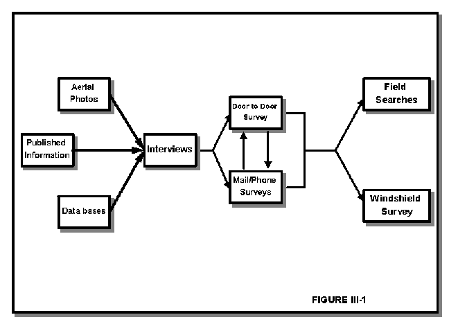
Figure III-1 illustrates a recommended approach to collecting information on potential sources.
1. Access and record existing data:
A substantial amount of inventory data base material and other information on known existing sources of contamination is available from local, state and federal agencies for use in developing and completing source inventories. Table III-2 presents a listing of many of the local, state and federal agencies that may have useful databases and related information for completing source inventories.
|
WYOMING DEPARTMENT OF ENVIRONMENTAL QUALITY (WDEQ) 122 W 25TH STREET, 4W CHEYENNE, WY 82002 |
|
| AGENCY | INFORMATION AVAILABLE |
|
Water Quality Division (WQD) District Offices Cheyenne: 307-777-7781 Lander: 307-332-3144 Sheridan: 307-672-6457
|
* NPL/CERCLA/FUD Sites (DSMOA Program) * Emergency Spills, Leaks, Complaint Investigations * Leaking Underground and Above Ground Storage Tanks * Surface Water Discharge Permits (NPDES) * Storm Water Pollution Prevention Plans & Permits * Sewage Treatment Plants & Wastewater Permits * Industrial Wastewater Treatment Plants * Animal Waste Management Facilities (over 1000 animal units) * Injection Wells (Classes I, II, III, IV & V) * Groundwater Monitoring Systems * Private Septic System Rules and Permits * Pesticide Monitoring in Groundwater * Wellhead Protection Planning * Groundwater Quality Information * Groundwater Pollution Investigations * Groundwater Sensitivity (Pollution Potential) and Aquifer Vulnerability Maps * Public Water System (PWS) Construction Permits * Non-Point Source Pollution Control Program * Subdivision Permit Reviews |
|
Solid and Hazardous Waste Division (SHWD) District Offices Cheyenne: 307-777-7752 Lander: 307-332-6924 Casper: 307-473-3750
|
* Hazardous Material Treatment, Storage and Disposal Facilities * RCRA Permits/Hazardous Waste Facility Cleanup * Solid Waste Management Storage, Treatment and Disposal Facilities (land farms, landfills, etc.) * Incinerators, Transfer Stations, Recycling Centers * Pollution Prevention (Assistance to Industry Regarding Source Reduction, Recycling or Treatment to Reduce Toxicity or Volume) |
|
Land Quality Division (LQD) District Offices Cheyenne: 307-777-7756 Lander: 307-332-3047 Sheridan: 307-672-6488 |
* Mine Permits * Underground Mines * Above Ground Mines
|
|
Abandoned Mine Lands (AML) District Offices Cheyenne: 307-777-6145 Lander: 307-332-5085 Casper: 307-473-3460 Sheridan: 307-672-6457 |
* Abandoned Mine Areas * Acid Mine Drainage
|
|
OTHER STATE AGENCIES |
|
|
Wyoming Oil and Gas Conservation Commission (OGCC) Casper: 307-234-7147 |
* Oil & Gas Wells * Oil and Gas Production, Refining, Transport (Pipelines) & Storage Facilities |
|
Wyoming State Geologic Survey Laramie: 307-766-2286 |
* General Geologic information * Geologic and Topographic Maps * Mineral Production and Reserves |
|
Wyoming State Engineerĺs Office (SEO) Groundwater Division Cheyenne: 307-777-6163 |
* Well Completion Reports; Permits for water supply wells and monitoring wells * Ground Water Resource Information |
|
Wyoming Department of Agriculture Technical Services Cheyenne: 307-777-6590 |
* Certification of Pesticide Applicators * Pesticide and Fertilizer Best Management Practices (BMPs)
|
|
Wyoming Department of Transportation (DOT) Maintenance Dept. Cheyenne: 307-777-6590 |
* Identification of DOT Storage Sites of regulated and non-regulated substances (e.g., salt) * Hazardous Cargo Shipments and Routes * Chemical Usage Locations * Aerial Photography Services |
|
Wyoming Water Resource Center (WWRC) Laramie: 307-766-2143 |
* Groundwater Sensitivity Maps and Aquifer Vulnerability Maps * Water Quality Databases * Wyoming Water Bibliography |
|
LOCAL/COUNTY AGENCIES |
|
|
County Health Departments |
* Private small On-Lot Sewage Disposal Permits (e.g., septic tanks, leach fields) * Private Well Testing * Pollution Investigations |
|
Weed & Pest District Offices |
* Pesticide use data; Pesticide Best Management Practices |
|
Road and Bridge Departments |
* Guidelines for Road De-Icing, Chemical Storage & Application * Location of Hazardous Materials Storage and Use * Location of Road Salt Storage and Use |
|
Local Emergency Planning Committees (May be part of Sheriffs Office/Fire Departments) |
* Hazardous Materials Inventory * Spill, Leak and Accident Reports * Location of Hazardous Materials Storage and Use * Contingency Plans |
|
Zoning and Planning Commissions |
* Waste District Planning * Previous Pollution Source Inventories & Other Resource Evaluation Studies * Base Maps and Copies of Ordinances and Zoning Studies * Zoning and Land Use Maps |
|
Agriculture Extension Service |
* Education on Agriculture Best Management Practices, Well Construction and Maintenance, On-Lot Sewage Systems |
|
Conservation Districts |
* Technical Assistance & Agricultural Best Management Practices & Pollution Abatement Measures |
|
Fire Marshall/Local Fire Departments |
* Records of Underground Storage Tanks for Flammable and Other Potential Fire Hazards * Reports & Locations on Pollution Incidents Involving Toxic, Hazardous or Flammable Substances |
|
City/County Engineers; Local Building, Zoning, & Utility Departments; Board of Public Utilities |
* Building Permits, Inspection Records * Sewer, Water & Gas Lines * Zoning & Plat Maps * Proposed Utility Expansion Location |
|
Waste Water Treatment Plant |
* Location of Wastewater Treatment Ponds and Lagoons * Storage Location of Treatment Chemicals |
|
City/County Engineers |
* Locations of Water & Sewer Distribution Lines; Wastewater Discharge Locations |
|
OTHER ENTITIES |
|
|
Local Golf Courses |
* Storage Sites for Pesticides/Herbicides * Areas of Pesticide/Herbicide Application |
|
Local Chamber of Commerce and Better Business Bureau |
* Business/Industry Directory
|
|
Libraries University of Wyoming Geologic Library ("Fee for Service") Laramie: 307-766-3374 |
* Maps * Aerial Photographs * Documents * Larger Libraries may be connected to CARL (the on-line catalog of the University of Wyoming Library System) |
|
Historical Society |
* Historic Maps * Aerial Photographs * Other Records of Possible Interest |
|
USDAĺs Agricultural Stabilization & Conservation Service (ASCS): Aerial Photo Field Office 2222 W 2300 S. St Salt Lake City, UT 801-524-5856 |
* Aerial Photographs
|
|
U.S. Geological Survey (USGS) Water Resources Division Cheyenne: 307-778-2931 National Mapping Office Denver: 303-236-7477 |
* Hydrogeologic Maps, Reports and Information * Geologic Maps, Reports and Information * Topographic Maps and Information |
|
Federal Emergency Management Agency (FEMA) |
* Flood Plain Maps (100-500-year flood areas)
|
|
U.S. Coast Guard-National Response Center Second Coast Guard District St. Louise, MO 314-425-4655 |
* Records of Reported Releases of Hazardous substances (e.g., from highway accidents) |
|
USDAĺs Natural Resource Conservation Services (NRCS) (Formerly SCS) |
* Soil-type Maps with Coverage of all of Wyoming |
Federal Databases
|
CERCLA INFORMATION SYSTEM (CERCLIS) |
|
|
Description: An inventory of potential hazardous waste sites in the United States. CERCLIS covers incidents of hazardous chemical spills as well as hazardous waste sites nominated or selected for cleanup under the provision of the Superfund Amendments and Reauthorization Action 1986 (SARA). |
|
|
Developed by: US EPAOffice of Emergency & Remedial Response Office of Solid Waste & Emergency Response
Contacts: FOI Office (A-101)US EPA 401 M. Street, SW Washington, DC 20460 (202)260-4048
US EPA
CERCLIS Hotline
US EPA Region VIII |
Information Available:
|
|
TOXIC CHEMICAL RELEASE INVENTORY (TRI) |
|
|
Description: TRI contains a compilation of the annual toxic chemical release reports required under Section 313 of the Emergency Planning and Community Right-to-Know Act. |
|
|
Developed by: US EPAOffice of Toxic Substances Emergency Response Division
Contact: Information Management DivisionPublic Data Branch (TS-793) US EPA 401 M. Street, SW Washington, DC 20460 (202)260-8680
US EPA Region VIII |
Information Available:
|
|
RCRA INFORMATION SYSTEM (RCRIS) (replacing HWDMS) |
|
| Description:This database contains permitting and compliance monitoring activities for all generators, transporters, and Treatment, Storage and Disposal facilities. | |
|
Developed by:
US EPA
Contacts:
US EPA
US EPA Region VIII |
Information Available:
|
|
HAZARDOUS MATERIAL INCIDENT REPORTING SYSTEM |
|
|
Description:This database provides a statistical compilation of all accidents and incidents involving hazardous materials. The system contains the following: |
|
|
Developed by: US Department of TransportationResearch & Special Programs Administration Information Systems Branch Contacts:
US Department of Transportation |
Information Available:
|
|
FEDERAL REPORTING DATA SYSTEM (FRDS) |
|
|
Description:FRDS organizes and stores information on public water supply systems (PWSS). |
|
|
Developed by:
US EPA Contacts:
US EPA Region VIII |
Information Available:
|
The following are examples of additional types of local information that can be used to screen for existing and potential contaminant sources within the WHPA, and are recommended for use in completing 'Source Identification' forms and developing the 'Source Inventory' list (described below):
2. Identify Ĺpotentialĺ sources for further study:
A good map to consult when investigating potential sources is the town's map of the community sewer service network. The intent of the sewer network is to collect and transport raw waste to the sewage treatment plant where it can be treated prior to disposal. When a map of potential contaminant sources is compared to a utility map indicating where the sewers are, it will become obvious where to look for existing and/or potential discharges to groundwater - at those sources not served by the sewer network. City/town engineers also should be consulted to identify portions of the sewer system network that are known or suspected to have failed or are in need of repair.
Current zoning maps and aerial photos assist in identifying the various types of activities which may be occurring within the wellfield area. Comparison of current maps and photos with older versions often illustrates historical practices or sources which may have impacted groundwater or warrant closer study. Aerial photos usually are available through the local NRCS, survey firms, or historical archives in community libraries.
Additional sources of information documenting past and present land uses include 1) local registries of commercial and industrial activities; 2) property transfer records, titles and deeds; and 3) senior citizen interviews regarding locations and practices of historic sources which are no longer in existence.
The following steps discuss procedures which should be implemented to further refine and develop the Source Inventory list: 3. Access Unknown Sources:
'Known' sources are those that already are included in files or data bases, while 'unknown' sources generally are not subject to regulatory controls or have not been brought to the attention of authorities due to oversight or lack of concern. Collecting information on unknown sources generally requires some type of survey to collect information of concern for WHP. This step also provides an opportunity to check information obtained from other sources and to obtain information about previously identified sources that warranted further study. The most thorough and effective way to obtain additional and new information on potential sources usually is through one or more of the following survey types:
One, or a combination of the survey types listed above must be used to refine and develop the Source Inventory list. WHP plans must identify the type of survey(s) implemented and discuss the measures which were taken to ensure thorough and complete survey coverage within the WHPA.
4. Verify accuracy and reliability of the information gathered on 'Known' and 'Unknown' Sources:
One of the best ways to ensure accuracy of information gathered during source identification is through field checking via "walking tours" or windshield surveys. Information collected through personal interviews can be verified by actual site visits. Telephone confirmation can be useful where a source facility is unmanned (e.g. oil wells). Cross-checking existing databases with any of the survey approaches described above is an acceptable way to verify information on existing and potential sources.
III. Describe sources within the WHPA:
1. Complete Source Identification forms (See Model Form III-1: Appendix H) for each existing and potential source of contamination identified within the WHPA:
Form III-1 (Source Identification Form) is a model form recommended for use by communities performing source inventories.
At a minimum, a form containing the following information must be completed and maintained for each source identified:
Completed Source Identification forms must be included in the WHP plan.
IV. Develop the Source Inventory list from completed Source Identification forms:
Using information from the completed Source Identification forms, the Source Inventory list is developed.
The Source Inventory list must contain:
* Source Inventory lists developed from Source Identifications based upon an estimated WHPA, or which are developed from Source Identifications completed prior to delineation of the WHPA are 'Preliminary' Source Inventory lists; a statement must be included that describes when and how the 'Preliminary' list will be updated (to a 'Final' Source Inventory) upon delineation of the WHPA (as described in Section II) to ensure that the entire area within the delineated WHPA has been inventoried.
A 'Final' Source Inventory list can be completed within one (1) year of completion of the WHPA delineation for which it was developed and still be considered valid by WDEQ/WQD.
Upon completion, information from the Source Inventory list should be used to complete Parts V and VII of the "Susceptibility Assessment Form" (Appendix F).
V. Prioritize sources within the WHPA for management purposes:
In order to evaluate the relative degree of risk that individual sources identified on the Source Inventory list pose to PWS wells, each source must be ranked (prioritized) according to one of the following methods:
Prioritization of sources is intended to provide the WHP Management Committee an efficient and effective guide in developing and implementing source management approaches (e.g. site inspections, monitoring, data collection, education, etc.) to protect the well or wellfield from contamination.
VI. Transfer source location and information to WHPA delineation maps:
Once all potential sources have been identified, each source must be plotted on a 'Source Overlay' map of the WHPA delineation map (see Section II). The map must distinguish between 'existing' and 'potential' sources as defined at the beginning of this section. Each source must be identified by a number that links the map location to the information on the Source Inventory list. Different symbols or colors should be used to differentiate between source types, both existing and potential. The Source Overlay must be identified as either 'Preliminary' or 'Final', according to the definitions used above.
VII. Update, Refine and Expand Source Inventory information:
- Expanding Source Inventory:
Reasons to expand the Source Inventory include: 1) new categories (Table III-1) are identified; 2) new sources (Form III-1; Appendix H) are identified, and; 3) new information is obtained on inventoried sources.
- Updating Information:
Methods to update the Source Inventory list include: 1) periodic review of existing inventory database material and other information on existing and potential sources of contamination available from local, state and federal agencies, and other public information, and; 2) periodic performance of surveys. The Source Inventory list must be updated at least every two years (see Section VIII of this document), using any combination of the methods described earlier in this Section.
- Refining Information:
Communities are encouraged to convert Source Inventory data to more useable forms. Methods to accomplish this objective include: 1) standardize data collection methods; 2) organize data by source priority ranking, contaminant of concern, contaminant TOT to the well, etc., and; 3) development of computer databases for efficiency in tracking, organizing and querying source information (data) sets.
- Data Bases:
Development of a computerized data base on potential sources of contamination within each WHPA is strongly recommended in preference to a manual data base. The types and qualities of data that are to be incorporated into the data base should be specified and evaluated. Data base design involves the formation of a conceptual model of the data (i.e., relationships between different data fields) taking into account all the basic facts and constraints under which the data base will have to operate. Once a data base design is selected, detailed decisions are made on the logistic and physical organization and the layout of data records to facilitate the entering of data to create the data base. Finally, through the data base monitoring phase, the data management system can be fine tuned and modified to increase the effectiveness and efficiency of the system for data retrieval and analysis.
The primary objective of developing a data base is to enable the analysis and processing of data to reveal relationships among various facts and situations. The data base should contain and be organized using information on: (1) types of land-use activities; (2) the spatial location of the identified sources; (3) chemical composition of the material stored or processed at the identified sites; (4) the name of the facility and the owner or operator, and; (5) other information that may be collected as part of the survey.
Ideally, information on potential sources of contamination should be analyzed in conjunction with hydrogeological data and water supply information to provide a basis for decision making on source reduction, aquifer protection, and water quality monitoring. A data base on the spatial distribution of chemical use and disposal is essential for evaluating the need for, type, and location of monitoring activities for potential contaminants. If a contamination event is detected, a data base on the distribution and use of chemicals would allow for a timely and efficient allocation of resources to determine the source or sources of contamination.
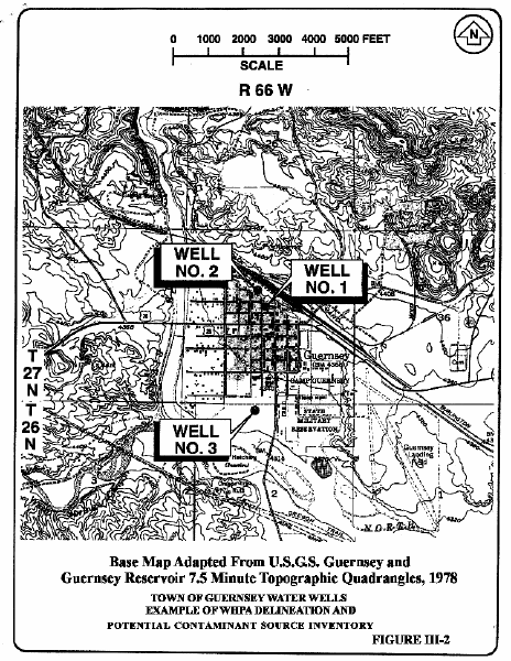
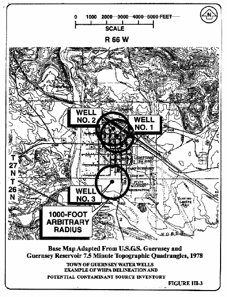
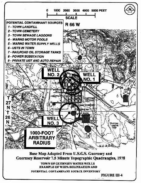
As an illustrative example, a basic inventory of potential contamination sources is presented in this section for the Town of Guernsey. Figure III-2 is the base map showing locations of the three municipal water supply wells. Municipal wells produce groundwater from the North Platte alluvium (CF p. 31 Section III; GW/SW Interaction Areas) located within and around the Town of Guernsey. Figure III-3 superimposes WHPAs on the base map. WHPA boundaries were delineated using the arbitrary fixed radius method at a 1000-ft radius around each water supply well. The fixed radius method for WHPA delineation was selected for illustrative purposes to step through the process of inventorying potential contamination sources. Figure III-4 shows potential contamination sources in relation to WHPAs, as discovered by a windshield survey.
Results of this delineation and inventorying process indicate of large amount of overlap of WHPAs for Well Nos. 1 and 2 within the Town, while Well No. 3 is more remotely located. For this example, it may be simpler for management purposes to combine WHPAs for Well Nos. 1 and 2, and treat as a single WHPA (refer to Figure III-3).
Although this preliminary inventory is based on a cursory, windshield survey, it is interesting to note the density of potential contamination sources is roughly similar for all wells, whether they are within the Townĺs boundary or located in an outlying, rural area.
Sections
1 |
2 |
3 |
4 |
5 |
6 |
7 |
8
Appendices
A |
B |
C |
D |
E |
F |
G |
H |
I |
J |
K |
L |
M |
N |
O |
P |
Q |
R
Wellhead Protection Program Guidance Document Contents
Wyoming Department of Environmental Quality