Subsection 1428(e) of the Safe Drinking Water Act Amendments of 1986 identify a 'Wellhead Protection Area', or WHPA (pronounced wa'puh) as:
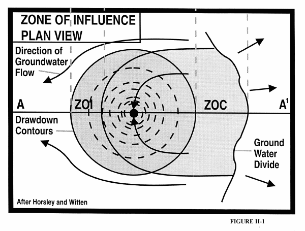
As illustrated in Figures II-1 and II-2, the area of influence, or "cone of depression", of a well or well field is referred to as its Zone of Influence (ZOI). The 'Wellhead Protection Area' (WHPA) is the entire area contributing water to the well or well field, including all or some of the ZOI, and is commonly referred to as the Zone of Contribution (ZOC) to the well, or the "capture zone" of the well. Contaminants introduced at the ground's surface within this zone could reasonably be expected to reach a well.
Subsection 1428(a)(2) of the SDWA establishes the requirements for WHPA determinations:
The size and shape of the Wellhead Protection Area depends upon the hydrogeologic characteristics of the aquifer system, and the design and operational characteristics of the well(s) used to pump water from the aquifer system. The goal of Wellhead Protection Plans is to protect groundwater within the WHPA by managing the potential risk of contamination that may be posed from potential contaminant sources that are located within the Zone of Contribution of the well.
One of the initial objectives in development of local WHP Plans should be the identification and mapping, or delineation, of the area that supplies water to a well (i.e. Zone of Contribution, or WHPA). The mapping process is called delineation of the Wellhead Protection Area, described in more detail below.

The method of establishing different "zones" within a wellhead protection area has been adopted by the Wellhead Protection Advisory Committee as the approach that Wyoming PWSs will use to delineate Wellhead Protection Areas (WHPAs).
Wyoming's Wellhead Protection (WHP) Plan defines three zones within the WHPA. These include: The 'accident prevention zone' or 'sanitary protection zone' (Zone 1); the 'attenuation zone' (Zone 2) and; the 'remedial action zone' (Zone 3).
Zone 1 constitutes the accident prevention zone or sanitary protection zone and is a highly protected area around the wellhead or the collection area infrastructure around a spring or tunnel. Its purpose is to protect the annulus of the well, or the spring and tunnel collection area from the direct introduction of contaminants into the well and its immediate area from spills, surface runoff, or leakage from storage facilities or containers. Potential contaminant sources in Zone 1 should be strictly monitored, controlled or excluded to insure that contaminants are not accidentally or intentionally introduced into the aquifer at, or near the wellhead.
Zone 2, the attenuation zone, is established to protect a well from contact with pathogenic microorganisms (e.g. bacteria and viruses) which can emanate from a source (e.g. septic system, etc.) located close to the well, as well as to provide emergency response time to begin active cleanup and/or implementation of contingency plans should a chemical contaminant be introduced into the aquifer near the wellhead.
Zone 3 is defined as the remedial action zone and is designed to protect the well from chemical contaminants that may migrate to the well; it typically includes a major portion of the recharge area, or Zone of Contribution to a well. Zone 3 should be sufficiently large to provide adequate time to detect and respond to a contaminant release, including time to develop a new drinking water source or supply in the event of a release within the Zone.
WHPA Delineation Procedure Overview:
Delineation of WHPAs depends not only on the characteristics (i.e., type of media and type of flow) of the aquifer, but also on the construction and operation of the well. This section identifies minimum criteria and minimum acceptable WHPA delineation methods for the principal types of aquifers (e.g. porous, carbonate, fractured and faulted) and hydrogeologic flow conditions (i.e. porous, diffuse and conduit) that are likely to occur with Public Water Systems (PWSs) within Wyoming.
An understanding of the delineation methods, their related requirements for data and resources, and their respective strengths and limitations is essential in establishing a local WHP plan. The reader is encouraged to refer to Appendix D ("Methods for the Delineation of Wellhead Protection Areas") for more information on delineation methodologies. Appendix E ("The Aquifers and Aquifer Systems in Wyoming") provides a basic overview of the geologic and hydrogeologic settings in Wyoming.
It is important to understand that the accuracy, and therefore the validity, of any delineation of a WHPA is a function of several factors, including: amount of information available regarding aquifer and well characteristics; the accuracy of the information, and; the delineation methodology selected and applied. Delineations based upon adequate and accurate information will generally be more accurate (and defensible) than one where little information, or erroneous information on either aquifer or well characteristics is utilized. Similarly, WHPAs delineated by one of the more sophisticated delineation methodologies (e.g. Numerical Models) will generally be more accurate and defensible than those delineated by one of the simpler methods (e.g. Arbitrary Fixed Radius).
Keeping in mind that one of the fundamental purposes of delineating a WHPA is to define the 'true' area within which potential contaminant sources and land use activities are to be evaluated for management approaches (to reduce the risk of contaminating the aquifer), the accuracy of the delineated wellhead protection area is important for three primary reasons:
Equally important, in the event that a community wishes to use the delineation of its WHPA as part of its justification to obtain monitoring waivers (to SDWA requirements), the delineation methodology must be reasonable and applied to appropriate hydrogeologic settings. This becomes especially important when viewed in light of the fact that reduced monitoring requirements, if obtained, eliminate a degree of certainty or verification that citizens who derive their drinking water from a PWS are being provided safe drinking water.
In evaluating the delineation methodologies to be applied within Wyoming, the Wellhead Protection Advisory Committee recognized the fact that many of Wyoming's PWSs are small systems in terms of population served, often with limited resources and technical expertise available to perform and complete the more sophisticated delineation methodologies identified in Appendix D. However, the Committee also recognized the benefits of using site specific information (i.e. aquifer/pump test data, etc.) to apply one of the more sophisticated (and generally more expensive) methodologies in order to obtain a more accurate delineation of a Wellhead Protection Area.
Process of WHPA Delineation:
The common steps to delineating WHPAs are:
Each of these steps in described in greater detail in the remainder of this section of the document.
Aquifer Media and Groundwater Flow Types:
WHPAs will vary in size and shape. The size of the WHPA is strongly influenced by the well pumping rate, aquifer porosity, and hydraulic conductivity of the aquifer media. The size and shape of the WHPA are strongly influenced by the groundwater gradient and flow direction, the orientation and density of fractures and faults, and solution features such as karst.
Porous media aquifers have fairly homogeneous distributions of solid materials and interconnected pore spaces, such as sandstones and alluvium. Aquifers that are fractured or faulted, comprised of solution features such as karst in carbonate formations, or other features allowing rapid fluid flux rates such as tunnels or flowing springs, often exhibit heterogeneous distributions of solid materials and interconnected pore spaces. These latter types of aquifer media can exhibit highly irregular and unpredictable flow characteristics which make delineation of appropriate WHPAs more difficult and less concise.
Unfractured and unfaulted porous media exhibit porous flow, or groundwater movement down-gradient through the pore space of aquifer rocks. Darcy's law is operative in porous flow environments. Porous flow conditions are common within sedimentary rocks (e.g. sandstones, siltstones, etc.) comprising thick sections of many of the state's interior, inter-montaine basins (e.g. Powder River, Wind River, Green River, etc.).
Aquifers comprised of fractured or faulted media (sedimentary, igneous or metamorphic), karstified carbonate media, tunnels or springs can exhibit either diffuse or conduit flow.
Conduit flow describes groundwater movement down-gradient along a pathway comprised of interconnected fractures, faults, joints, and solution openings, resulting in a rapid response to recharge, turbulence, and highly variable chemistry, temperature, and flow rates. Darcy's law is not operative under conduit flow conditions. Conduit flow conditions can exist within sedimentary, igneous or metamorphic rock sequences but are most commonly associated with karst carbonate rocks and igneous and metamorphic rocks comprising the state's mountainous regions.
Diffuse flow occurs as groundwater movement through interconnected fractures, faults, joints, and bedding planes resulting in less turbulent flow, less dramatic response to recharge events, and more uniform chemistry than observed in conduit flow. Diffuse flow is similar to porous flow, indicating that at the scale of interest (the size of the WHPA), flow in the aquifer may be described as a porous media equivalent. This typically occurs where the fractures are dense and evenly spaced. Diffuse flow conditions can exist within sedimentary, igneous or metamorphic rock sequences but are most common within highly fractured sedimentary rocks situated within the state's interior basins, as opposed to mountainous regions.
Distinguishing Between Diffuse and Conduit Flow:
Diffuse flow in fractured, faulted, or karstified carbonate aquifers can sometimes be treated as a porous media equivalent at the WHPA scale. However, unless convincing evidence can be produced that these types of aquifers exhibit diffuse flow characteristics, conduit flow should be assumed.
The best criteria for determining whether fractured, faulted, or highly karstified carbonate aquifers can be treated as a porous medium (i.e. diffuse flow) for the purposes of delineating WHPAs include: aquifer/pump test responses, configuration of the water-table surface, the ratio of fracture scale to problem scale, distribution of hydraulic conductivity, and variations in water chemistry and water quality.
Aquifer/pump test responses:
"There are three main criteria for determining whether a fractured rock aquifer approximates a porous medium (i.e. diffuse flow) using an aquifer pumping test.
Full-scale aquifer/pump tests involving several monitoring wells probably provide the most reliable measure of aquifer parameters for wellhead protection studies. Although often a preferred method of data acquisition, aquifer/pump tests in fractured-rock systems can be expensive to conduct and complex to analyze.
Configuration of the water-table surface:
"For porous-media-equivalent fractured aquifers a water-table map should show a smooth and continuous water-table surface without areas of rapidly changing or anomalous water levels. In particular, the water table should not have the "stair-step"appearance that can occur in sparsely fractured rocks with large contrasts in hydraulic conductivity between blocks and fractures. Although a "stair-step" water table clearly indicates a failure of the porous-flow assumption, a smooth water-table map does not prove a porous-media-equivalent assumption. Detection of irregularities in the water table may require more closely spaced monitoring wells than are available for most wellhead protection studies.
Ratio of fracture scale to problem scale:
"For porous-media equivalent aquifers, the observed vertical and horizontal fractures should be numerous and the scale of fracturing should be much smaller than the scale of the wellhead protection problem. As a rule of thumb, the minimum dimension of the WHPA should be at least 100 (one hundred) times the average fracture spacing. For example, at the [sic] test site, bedrock fractures are numerous and occur on a scale of a few feet or tens of feet, but the potential WHPAs ...cover several square miles.
Hydraulic conductivity distribution:
"In porous-media-equivalent settings the distribution of hydraulic conductivity, as estimated from piezometric slug tests or from specific capacity analysis (Bradbury and Rothschild, 1985), should be approximately log-normal. In aquifers where the hydraulic conductivity distribution is strongly bi-modal, the porous-media assumption is probably not valid.
Variations in water chemistry:
"Overall variations in ground-water chemistry have been shown to be useful in determining whether fractured aquifers behave as diffuse-flow (porous-media) systems or as conduit (discrete-fracture) systems. In conduit systems, variations in ground-water chemistry can be significant from place to place and through time. Water moving through conduits usually has less contact time with mineral surfaces and so can be lower in total dissolve solids and have lower mineral saturation indices than water moving through a diffuse-flow aquifer having similar mineralogy. Ground water in diffuse-flow fractured aquifers will usually have a relatively high uniform chemical compositions through time and from place to place within the aquifer. For example, Shuster and White (1971) examined water chemistry and temperature of several springs in Pennsylvania and showed that water chemistry in conduit-flow springs varied greatly with time, but the water chemistry of diffuse-flow springs did not. Municipal wells are sampled on a regular basis for such parameters as temperature, pH, hardness, turbidity and bacteria. The variation in these parameters can help determine whether a fractured-rock aquifer behaves as a porous medium. For example, ground water high in turbidity and bacteria is more often a result of conduit flow rather than diffuse flow. If a production well never has a turbidity or bacteria problem, it is probably not connected to significant conduits intersecting the land surface."
If none of the above data are available, subjective techniques can sometimes be used to estimate whether diffuse or conduit flow is present. Through the use of topographic, geologic and hydrogeologic maps, air photos, and/or published reports, basic conclusions can be made regarding the type of flow (i.e. conduit versus diffuse) is likely to be present within the aquifer.
A determination of the type of flow (i.e. porous, diffuse, or conduit) that prevails within the aquifer is the first step in determining which method(s) are acceptable for delineating the Zones within the WHPA. Table II-1 illustrates a decision tree to follow in order to help determine the prevailing type of flow.

Wyoming's Wellhead Protection Advisory Committee accepted the following criteria and methodologies for WHPA delineations. The criteria adopted for the delineation of WHPAs (and the Zones which comprise the WHPA) include 'Radial Distance from Well', 'Time of Travel (TOT)', and 'Flow-System Boundaries' and 'Vulnerability Mapping' as determined from hydrogeologic mapping and/or field tests. The accepted methodologies are detailed in Appendix D, with baseline methodologies addressed below.
The most basic criterion for WHPA delineation is the radial distance from the well without regard for the ground-water flow direction. In its simplest form, the distance criterion forms the basis of the Arbitrary Fixed Radius method which delineates a WHPA by placing a circle of fixed radius around the well.
The TOT criterion bases WHPA delineations on the amount of time it takes ground-water to travel from a point source to a well. Again, without regard for the ground-water flow direction, time of travel criteria, combined with radial distance from well criteria form the basis of the Calculated Fixed Radius (CFR) method. The CFR method establishes a circular WHPA for porous and/or diffuse flow conditions according to site-specific data including porosity, pumping rate, and the screened/open interval of the well. Consideration of ground-water flow velocities and flow directions can also be incorporated with time of travel criteria in more advanced delineation methodologies. Appendix D provides additional information on application of the CFR delineation methodology.
The flow-system boundary criterion uses ground-water divides, surface-water bodies, or other hydrologic, physical, or geologic features to delineate a WHPA. In aquifers with conduit flow, flow system boundaries (e.g. groundwater divides, aquifer truncation, recharging surface waters, etc.) are established using either Hydrogeologic Mapping or Field Methods, or a combination of both. Groundwater Vulnerability Mapping techniques delineate vulnerable' areas (e.g. faults, fractures, exposed bedrock, etc.) where groundwater within the producing aquifer may be intrinsically susceptible to rapid infiltration of contaminants released at the ground surface. Hydrogeologic expertise or experience may be necessary to delineate WHPAs based on flow-system boundary criteria. Refer to EPA's guidance document "Delineation of Wellhead Protection Areas in Fractured Rocks" for further information regarding the delineation of WHPAs using Field Methods, Hydrogeologic Mapping, and Vulnerability Mapping techniques. Also see Appendix D for more details.
Minimum Baseline Methodologies and Criteria for WHPA Zones 1, 2, and 3:
The Wyoming Wellhead Protection Plan Advisory Committee adopted the use of Fixed Radius (Arbitrary and Calculated) and Hydrogeologic Mapping (including Vulnerability Mapping) and/or Field Methods methodologies coupled with a determination of susceptibility to contamination (see Appendix F: 'Susceptibility Assessment Form' and Appendix G: 'Assistance Packet - Susceptibility Assessment Form') as the minimum, or baseline, needed to meet WDEQ standards of acceptance. The adopted minimum criteria are discussed below.
At a minimum, the Arbitrary Fixed Radius method will be used to delineate Zone 1 of the WHPA, and the Calculated Fixed Radius method (porous and diffuse flow) or the Hydrogeologic Mapping and/or Field Methods method (conduit flow) coupled with Vulnerability Mapping will be used to delineate Zones 2 and 3.
Whenever practicable, the use of more sophisticated delineation methodologies (see footnote 1, Table II-2) that produce WHPAs which more accurately represent site-specific data well and aquifer conditions is encouraged. 'Community' PWSs are encouraged to initially delineate their WHPAs for both existing and new wells using aquifer/pump test data and results to apply either Analytical or Numerical modeling whenever practicable.
When aquifer/pump tests are performed for the installation of new wells or the rehabilitation of existing wells using state or federal funding, Analytical Models or Numerical Models (Appendix D) should be used instead of the Calculated Fixed Radius method, where applicable, to delineate the WHPA Zones.
The baseline methodologies for Zones 1, 2, and 3 are set forth below and are summarized in Table II-2; see Appendix D for details on all delineation methodologies, and the Glossary for further definition of aquifer media (i.e. porous, carbonate, fractured/faulted, springs, and tunnels) and flow types (i.e. porous, diffuse, and conduit).
Circumstances where these baseline methodologies may be inappropriate are subsequently detailed under "Special Considerations" below.
Minimum Criteria:
The minimum criteria (i.e. values for the minimum 'Radial Distance from Well', 'Time-of-Travel (TOT)', and 'Flow-System Boundaries' for Zones 1, 2, and 3 are set forth below and are summarized in Table II-2.
| Protection Zones |
Aquifer Media and Groundwater Flow Types | ||
| Porous Media | Springs, Tunnels, Carbonate or Fractured/Faulted Media |
Springs, Tunnels, Carbonate or Fractured/Faulted Media |
|
| Porous Flow Criteria |
Diffuse Flow Criteria(4) |
Conduit Flow Criteria |
|
| Zone 1 | 50 or 100 ft (2) | 50 or 100 ft (2) | 100 ft |
| Zone 2 | 2 year TOT radius (3) |
2 year TOT radius (3)(4) | Vulnerable Areas Within Flow System Boundaries (5) |
| Zone 3 | 5 year TOT radius (3) |
5 year TOT radius (3)(4) | Flow System Boundaries (5) |
Refer to EPA's guidance document "Delineation of Wellhead Protection Areas in Fractured Rocks" for further information regarding the delineation of WHPAs using Field Test Data, Hydrogeologic Mapping, and Vulnerability Mapping techniques.
Zone 1:
The Arbitrary Fixed Radius method is the baseline method for delineating Zone 1. The boundary of Zone 1 is set at an 'arbitrary' fixed radius of 50' or 100' from the well (or spring or tunnel), dependent upon factors such as well construction characteristics and proximity to potential contaminant sources:
B. A 100' radius (minimum) Zone 1 will be applied to those wells which do not meet the criteria described in A (1-4), above, and PWSs using springs and/or tunnels for drinking water supplies.
Zone 2:
The following criteria (and baseline methodologies) provide a minimum distance (based upon Time-of-Travel or Vulnerable' Areas) for the boundary of Zone 2:
NOTE: Under certain circumstances the Calculated Fixed Radius (CFR) method may not be appropriate and PWSs may be required to apply alternative criteria and/or methods to delineate the WHPA. Part VI of the 'Susceptibility Assessment Form' (Appendix F) provides assistance in determining if the CFR is appropriate for delineating WHPA Zones 2 and 3 for porous or diffuse flow. The following section titled Special Considerations describes additional conditions and situations where the CFR method is not appropriate for delineating WHPAs. If you need assistance in determining an acceptable delineation method, consult with WDEQ/WQD.
B. For wells completed in a karst, faulted (fault 'rubble zone') or fractured aquifers where flow may be characterized wholly, or in part, as conduit flow, and for PWSs which rely upon springs and/or tunnels for drinking water supplies, Zone 2 is defined by the location (i.e. delineation) of 'vulnerable' areas within the boundaries of the flow system supplying the well (spring or tunnel). Vulnerability Mapping and/or Field Methods are the baseline methods.
Zone 3:
The following criteria (and baseline methodologies) provide a minimum distance (based upon Time-of-Travel or Flow-System Boundaries) for the boundary of Zone 3:
NOTE: Under certain circumstances the Calculated Fixed Radius (CFR) method may not be appropriate and PWSs may be required to apply alternative criteria and/or methods to delineate the WHPA. Part VI of the 'Susceptibility Assessment Form' (Appendix F) provides assistance in determining if the CFR is appropriate for delineating WHPA Zones 2 and 3 for porous or diffuse flow. The following section titled Special Considerations describes additional conditions and situations where the CFR method is not appropriate for delineating WHPAs. If you need assistance in determining an acceptable delineation method, consult with WDEQ/WQD.
B. For wells completed in a carbonate, faulted (fault 'rubble zone') or fractured aquifers where flow may be characterized wholly, or in part, as conduit flow, and for PWSs which rely upon springs and/or tunnels for drinking water supplies, Zone 3 is defined by the flow-system boundaries of the flow system supplying the well (spring or tunnel) as determined from Hydrogeologic Mapping and/or Field Methods.
SPECIAL CONSIDERATIONS:
Delineation methods and criteria applicable to unique systems such as (1) springs and tunnels; (2) limestone wells; (3) wells and springs in crystalline and metamorphic rocks; (4) 'Buffer Zones' for recharge areas lying outside of WHPAs; (5) delineating WHPAs for multiple wells in a well field; (6) confined aquifers; (7) ground water/surface water interaction areas, and; (8) wells completed in multiple aquifers are provided as follows:
(1) Springs and Tunnels:
According to Jensen and others (1995), more than 100 PWSs in Wyoming use springs; these springs serve as the primary drinking water supplies for more than 10 percent of the state's population. Due to the complexity of conduit flow systems which frequently supply water to springs, the analytical and numerical methods commonly used to delineate protection zones for water supply wells generally do not apply. Hydrogeologic mapping or field tests should be used to identify geologic and hydrologic controls on groundwater flow to springs and to locate flow boundaries. This information should be used to specify "spring head" protection zones based on flow boundaries at sites where the zone of contribution to the spring is practicable to protect. Jensen and others (1995) indicate that hydrogeologic mapping, as applied to delineating protection areas for springs, refers predominantly to geologic, hydrologic, geochemical, and geophysical techniques for characterizing subsurface features using the surface expression and geophysical or geochemical signatures of such features. These techniques include fracture-trace analysis, analysis of land surface topography, geologic mapping, potentiometric surface mapping, geophysical surveys, tracer studies, stable and radioactive isotope studies, and geochemical characterization.
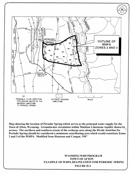
Information from such studies forms the basis for the conceptual model of groundwater flow to the spring. Depending on site conditions, groundwater flow boundaries and pathways may be identified and mapped in detail. In some cases, techniques used for surface watershed management, such as the program underway by the Town of Pinedale, may be appropriate. An example of WHPA delineation for the Periodic Spring serving the Town of Afton in the Overthrust Belt in southwestern Wyoming is depicted on Figure II-3. Note the estimated WHPA is irregular in shape and covers an area encompassing a few square miles. Given the knowledge of the spring hydraulics and local structural geology, as summarized by Huntoon and Coogan (1987), the protection zones could plausibly be reduced to the immediate area around the spring and the recharge area. Jensen and others (1995) provide case studies of the use of hydrogeologic mapping for delineating protection zones around springs in two different hydrogeologic settings in Utah.
Some PWSs in Wyoming are located close to old mine workings which eventually may be considered as drinking water supplies. A good example of this situation is the Town of Hartville which is located close to the old Sunrise iron ore mine. As with springs, analytical and numerical methods commonly used to delineate WHPAs for water supply wells generally are not applicable for tunnels. Hydrogeologic mapping or field tests should be used to identify geologic and hydrologic controls on groundwater flow to tunnels and to locate flow boundaries. This information should be used to specify "tunnelhead" protection zones based on flow boundaries at sites where the zone of contribution to the tunnel is practicable to protect. Hydrogeologic mapping, as applied to delineating protection areas for tunnels, refers predominantly to geologic, hydrologic, geochemical, and geophysical techniques for characterizing subsurface features using the surface expression and geophysical or geochemical signatures of such features. These techniques include fracture-trace analysis, analysis of land surface topography, geologic mapping, potentiometric surface mapping, geophysical surveys, tracer studies, stable and radioactive isotope studies, and geochemical characterization.
Information from such studies forms the basis for the conceptual model of groundwater flow to the tunnel. Depending on site conditions, groundwater flow boundaries and pathways may be identified and mapped in detail. As with springs, techniques used for surface watershed management such as the program underway by the Town of Pinedale may be appropriate.
Wells tapping the limestones in Wyoming are some of the largest producing wells in the Rocky Mountain region. For example, the Town of Worland reportedly uses a well which flows nearly 14,000 gallons per minute (gpm); the City of Gillette has several wells with yields ranging from 500 to 1,000 gpm. Borehole videotaping of many limestone wells located throughout the state reveals that groundwater flow into the wells occurs through pipe-like conduits (caves), along bedding planes, and fractures enlarged by solution; all of these features constitute karst conditions. The single most distinguishing feature of karst aquifers when contrasted with other aquifer types is that the voids in a soluble aquifer are predominantly created by the flow regime. Thus, the permeability structure in a soluble aquifer is (1) a consequence of the circulation system imposed on the aquifer, and (2) organized to facilitate the circulation of fluids in the down gradient direction. The permeability structure in a karst aquifer is not an independent, inherited static attribute of the rock. The rule of thumb for determining if you are dealing with a karst aquifer is: if carbonate rocks are present, assume you are dealing with karst even if no karst morphologic features are obvious.
Two major types of groundwater flow occur in karst aquifers: conduit flow which refers to groundwater flow through tubes; and diffuse flow, which refers to groundwater flow through integrated pores. Groundwater flow in conduits and fractures of karst aquifers differs radically from diffuse or porous flow in other aquifers. Conduit flow is generally much faster; flow rates for circulation of water through the subsurface approaches open channel surface water velocities. For example, dye tracing techniques in the Bighorn Mountains demonstrate that typical flow velocities in caves gave rise to off-range transit times of 2 to 12 days. From the perspective of WHPA delineation, a primary focus for groundwater protection are the source areas for the surface streams higher in the upland serving as the recharge area.
Exploring for and developing groundwater from karst aquifers in Wyoming can be some of the most formidable challenges facing even the most experienced groundwater scientists and engineers. The tasks of protecting wells tapping karst aquifers are obviously complicated by the extreme heterogeneities in the permeability architecture within these aquifers. As a consequence, PWSs relying on wells tapping these types of aquifers are encouraged to seek the professional advice of water professionals experienced with working in karst hydrogeologic settings.
(3) Wells and Springs Developed in Crystalline and Metamorphic Rocks:
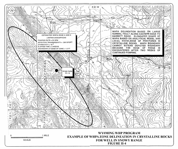
Some PWSs use springs and wells tapping fractures in the crystalline and metamorphic rocks composing the core of Wyoming mountain ranges. Good examples include some of the ski areas located throughout the state, as well as unincorporated communities such as Ryan Park near Saratoga, Vista West near Sundance, and the Hartville area. Because these rocks store water in fractures, the hydrogeologic setting is typically unconfined. Methods and criteria appropriate to the hydrogeologic setting should be used to delineate the WHPA for the well tapping these rocks. For example, the WHPA delineation for the crystalline rock well serving the Ryan Park area in the Snowy Range in southeastern Wyoming is depicted on Figure II-4. Note the elliptical pattern of the WHPA; this was derived by (1) hydrogeologic mapping of the hydrologic boundaries (i.e. flow-system boundaries) of the fractured rock aquifer, (2) extended aquifer/pump testing of the aquifer which provided hydrologic information suggesting the rocks were extensively fractured and reacted hydraulically as if the aquifer was a porous media equivalent, and (3) use of an analytical model to calculate the extent of the hydraulic cone of depression, with modifications based on the known hydrologic irregularities in the permeability distribution in the fractured rocks. One of the more interesting aspects of this WHPA delineation is that the simulated area of influence by the well corresponds with the known hydrogeologic boundaries, indicating the delineated WHPA reasonably represents the Zone of Contribution (ZOC) to the well under study. Further definition of 'vulnerable' areas (i.e. Zone 2) within the ZOC can be completed through hydrogeologic mapping or field tests.
(4) Recharge areas lying outside of Zones 1,2 and 3:
A Zone 3 WHPA delineated by CFR may not encompass the entire ZOC for a well in an area with a significant hydraulic gradient. Other methods of WHPA delineation that utilize a TOT calculation may have similar limitations. In some circumstances, such as when a vulnerable recharge area is located upgradient from a WHPA, the WHPA can be expanded in an upgradient direction in order to provide added protection. This expanded area can extend outward to include the entire ZOC.
This expanded area affords important protection to recharge areas beyond the WHPA boundaries, and can provide information on potential contaminant sources outside Zone 3 which have the potential for releasing contaminants into the wellhead protection area. Analysis may show the need for contingency plans to respond to uncontrolled surface discharges that may travel overland to enter a stream located in or adjacent to the WHPA. It may also identify other non-contiguous critical aquifer recharge areas requiring some from of protection.
(5) Delineation of WHPAs for Multiple Wells in a Well field:
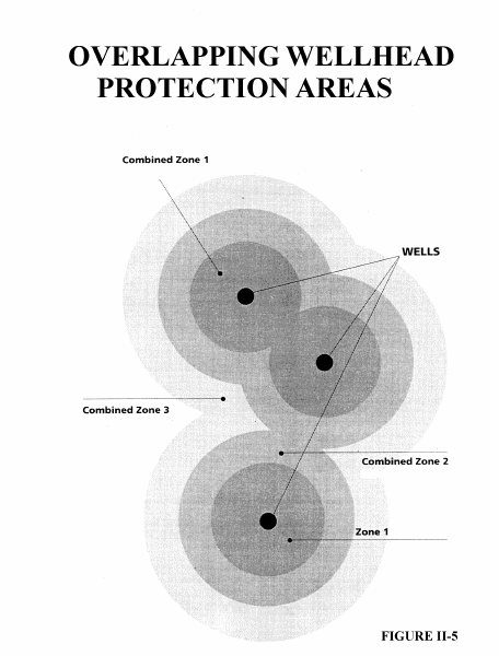
If the WHPAs of different wells overlap, the WHPA of the well field should be defined by combining (i.e. "nesting" or "clustering"; see Figure II-5) the individual WHPAs in areas where there is overlap. Where computer modeling approaches are used (e.g. WHPA, WhAEM, etc.) to delineate the WHPAs, interference of the wells on one another must be incorporated into the modeling.
The delineation approach for confined aquifers is the same as that for unconfined or semi-confined aquifers; refer to Tables II-1 and II-2. Confined aquifer conditions generally are less susceptible to contamination and often can justify reduced source management approaches that may be less prescriptive in nature. Recharge areas for confined aquifers should still be considered for inclusion in the protection plan.
(7) Groundwater/Surface Water Interaction Areas:
Groundwater and surface waters may be hydraulically connected. Wells located near rivers may draw a significant portion of their total withdrawal from the surface source. This is particularly true when the wells are hydraulically connected by fractures or in Ranney lateral collectors. A connection between a well and a surface source may be identified by examining water temperature fluctuation, or fluctuations in water chemistry of the well water which reflect changes in the surface water, or by Microscopic Particulate Analyses (MPAs). Another method of identifying hydrologic continuity is by the correlation of water levels and impacts of pumping on adjacent water levels both in surface waters and other wells.
If surface waters are discharging to groundwater, or a well is drawing water from surface supplies into its capture zone, that groundwater supply may be considered as Ground Water Under the Direct Influence (GWUDI) of surface water. Where this condition exists, the PWS is strongly encouraged to develop and implement a plan to prevent surface water contaminants from entering the well via groundwater. A groundwater source classified as a GWUDI may be subject to additional protection measures (e.g. surface watershed control plans), such as those being developed by the Town of Pinedale. Most groundwaters experience some degree of hydraulic continuity with surface waters, however the majority of groundwater-based PWSs are not GWUDIs.
Wells in direct hydraulic continuity with surface water must factor this condition into their delineation effort. Depending on the degree of connection, the surface source (river, lake) often serves as a hydrologic boundary, resulting in a smaller WHPA. Situations such as these usually require professional geologic/hydrogeologic assistance in delineation of the WHPA.
(8) Wells Completed in Multiple Aquifers:
Delineation criteria, thresholds and methodology(ies) for wells completed in multiple aquifers prior to promulgation of rules and regulations requiring sealing between aquifers [WDEQ/WQD Chapter XII, 1985] will be considered by WDEQ/WQD on a case by case basis.
WHPA DELINEATION REPORT:
WHP plans must contain a 'WHPA Delineation Report' for each well supplying groundwater used for drinking water. PWSs supplied by multiple wells completed within the same aquifer can summarize the information in one Delineation Report.
NOTE: 'Non-community' PWSs (see Glossary) do not need to develop and provide a copy of the WHPA DELINEATION REPORT described below. In lieu of the WHPA DELINEATION REPORT, they may complete a 'Susceptibility Assessment Form' (Appendix F) as their WHP Plan (including a map illustrating the WHPA(s) for each source) in order to have their WHP plan reviewed for approval. 'Non-community' PWSs must follow the same requirements as 'Community' PWSs for updating WHP plans (see Section VIII).
The Wyoming Water Resource Center and the University of Wyoming have assisted WDEQ/WQD in delineating WHPAs for many Non-Community' PWSs to adopt and incorporate into the Susceptibility Assessment Form, if they choose. Contact the WDEQ/WQD for further information.
The required contents of the Delineation Report are set forth as follows:
Geologic Data:
Aquifer Data:
If the groundwater source is a well, hydraulic conductivity and transmissivity data should be obtained from an appropriate aquifer/pump test. If a previously performed aquifer/pump test has been performed, is available and includes the data listed below, it may be used instead. Hydraulic data derived from hydrologic reports, or from areal or regional numerical modeling efforts also may be used.
If an aquifer test was conducted using a single well, the report must include the following information:
* NOTE:
Pump Data:
WHPA Delineation Information:
Map Showing Boundaries of the WHPA Zones:
In addition, the WHP plan should include a written description of the distances which define the delineated boundaries of Zone 2 and Zone 3. These written descriptions should include the maximum distances up gradient from the well (or collection area for a spring or tunnel), the maximum distances down gradient from the well, and the maximum widths of each protection zone.
Current Zoning and County Plan Map:
Confined Aquifer Conditions:
'Susceptibility Assessment Form' (Appendix F):
A completed 'Susceptibility Assessment Form' (Appendix F) also must be included with the Delineation Report for each 'Community' and 'Non-Community' PWS source' (i.e. well, spring, tunnel etc.) included in the WHP Plan.
Sources of Information:
Appendix E (The Aquifers and Aquifer Systems in Wyoming) contains general discussions of Wyoming geology and hydrogeology. Sources and contacts for additional information (including WHPA and WhAEM software and user guides) available for use in completing WHPA delineations and Delineation Reports are provided in Appendix C.
NOTE:
Sections
1 |
2 |
3 |
4 |
5 |
6 |
7 |
8
Appendices
A |
B |
C |
D |
E |
F |
G |
H |
I |
J |
K |
L |
M |
N |
O |
P |
Q |
R
Wellhead Protection Program Guidance Document Contents
Wyoming Department of Environmental Quality