Virtually all of the stratigraphic units in Wyoming basins play a hydrologic role either as a major aquifer, a minor aquifer, aquiclude or aquitard. Over 100 aquifers and aquifer systems have been identified within the State by Antcil (1994); however, many are limited in extent and yield only small amounts of water to wells and springs. The principal aquifer systems in the State include the unconsolidated alluvial deposits principally found along or adjacent to major drainages; semi-consolidated to locally consolidated sedimentary rocks forming the Tertiary aquifers; the consolidated sedimentary rocks (including carbonates) found within or flanking the structural basins and the Overthrust Belt of western Wyoming, and the crystalline and metamorphic rocks coring the mountain uplifts. Principal recharge of deeper aquifers is from basin margin outcrop areas, whereas more shallow aquifers receive recharge from outcrops, infiltration and vertical leakage between adjacent water-bearing units.
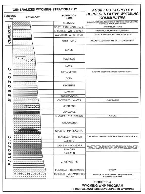
Figure E-2 depicts the generalized hydrostratigraphy of the State, along with a partial listing of Wyoming communities tapping the principal aquifers in the State. Note the majority of groundwater development in the State relies upon the alluvial aquifers situated along major drainages, the Tertiary aquifers, and the Paleozoic aquifer system.
Because of the diversity of the hydrogeology in the State of Wyoming, this section describes in summary form the major aquifers and/or aquifer systems of Wyoming. The purpose of this overview is to assist in first-order WHPA delineations by characterizing and documenting the hydrogeologic properties, water quality, availability, and use of the principal water-bearing units throughout the state.
The bulk of the following information has been adapted from Antcil (1994). Antcil completed extensive literature search of the available groundwater investigations, test data, and general stratigraphic and structural geology to identify currently-producing aquifers and those with a potential for development. No attempt was made to identify existing or potential groundwater availability or quality problems. These and other problems would be better addressed in more local studies.
By definition, the sedimentary and other rock sequences in the State that are comprised of permeable, water-saturated units which yield water to wells and springs are aquifers. Relatively impermeable rocks above and below aquifers are defined as aquitards, leaky aquitards, or confining layers. Aquifer systems refer to a series of stacked or serial aquifers that have similar hydraulic and geologic properties and are hydraulically connected, of reasonably large areal extent, and sealed from each other by regionally extensive confining layers.
HYDROGEOLOGY
There are three types of aquifers present in Wyoming, most of which have differing characteristics and requirements for evaluation, management, vulnerability and exploitation. In the state, unconfined aquifers consist of shallow flood plain (alluvial) and terrace deposits. Locally, glacial outwash deposits are important water-bearing units. Other unconsolidated bedrock deposits (such as the Ogallala Formation) can be several hundreds of feet deep and may be unconfined, semi-confined, and confined aquifers due to the complex stratigraphic architecture associated with deposition of the formation materials. Generally, these relatively shallow units are composed of sand, silt and gravel. These are the most vulnerable of all aquifers because of their shallow depths and general lack of laterally extensive confining layers.
Confined aquifers are those that exist within bedrock formations of differing permeabilities, such as sandstone or shale, and are stratigraphically bound by less permeable strata. As the water in these aquifers is under pressure greater than atmospheric, it causes water levels in wells to rise above the top of the confining unit in many instances. Often, a free-flowing artesian system is established. Groundwater from the confined aquifer may also discharge as a spring or from a flowing well, particularly those situated along an uplift or valley margin. These aquifers are the least vulnerable to human activities, except in special instances, such as penetration by a well which is poorly constructed or abandoned.
Fractured bedrock or solution-enhanced karst systems constitute some of the most productive aquifers in Wyoming. However, groundwater time of travel can be rapid and may be several orders of magnitude greater than groundwater circulation in other aquifers, thus increasing the vulnerability of the aquifers to contamination. Post depositional tectonic forces created most of the enhanced hydraulic characteristics of fractured bedrock aquifers, whereas fresh water derived from the mountain highlands created solution-enhanced channels in the carbonate rock units.
Alluvial Aquifers:
The U.S. Geological Survey has established three criteria that are used to differentiate alluvial aquifers from other types of aquifers (see Heath, 1984): (1) the valleys contain sand and gravel deposits thick enough to supply water to wells at moderate to large rates; (2) the sand and gravel deposits are in hydraulic connection with a perennial stream which serves as a source of recharge and whose flow commonly exceeds the demand; and (3) the sand and gravel deposits occur in a clearly defined band (or channel) that normally does not extend beyond the floodplain and adjacent terraces (the width of the deposits is small compared with its length).
The alluvial aquifers of Wyoming fit these criteria and consist mostly of alluvial and terrace deposits that border the major rivers in the State. Those deposits of importance are located along the North Platte, the upper Snake, the Bear, and the Greybull Rivers. Antcil (1994) reports that at least five additional rivers systems have been classified as alluvial aquifers, but are mostly of local concern.
The North Platte is an interstate stream that begins in northern Colorado, flows northward into Wyoming to the general area of Casper where it loops southeastward and exits the state into Nebraska near Torrington. Alluvium along the North Platte constitutes the largest alluvial aquifer in the state in terms of length, drainage-basin size and water storage, and availability for agricultural, municipal and industrial uses. It is comprised of unconsolidated sand, silt, clay and gravel, the local mix of which provides a variety of geologic and hydrologic aquifer conditions. The principal Wyoming communities relying on the alluvium along the North Platter River as a water supply include the City of Casper, and the Towns of Guernsey, Hartville, and Torrington.
Alluvium deposited along other major rivers in Wyoming also serve as community water supplies derived from wells. The upper Snake River heads in the Teton National Park area and flows southward ultimately entering Idaho. The Town of Jackson wells may partially tap the alluvium and older sediments along the Snake River. The Wind River heads in the Wind River Mountains and flows southeast to the Bighorn River. Wells serving the Town of Dubois tap the alluvium along the Wind River. Many of the small communities in the Star Valley located in western Wyoming may partially tap the alluvium and deeper sediments along the Salt River. It is certain other communities rely on alluvium associated with other rivers and streams in Wyoming.
High Plains Aquifer System:
Although the High Plains aquifer system underlies portions of eight states, in Wyoming it occurs only in the southeast quarter of the state. There it consists mostly of Tertiary and Quaternary sediments that are mostly unconsolidated with varying degrees of confinement by lower permeability strata. In general, the water-bearing strata in the upper portions of the aquifer are poorly consolidated and unconfined; the deeper water-bearing strata are typically more consolidated and semi-confined to confined by lower permeability strata.
Most groundwater in the High Plains aquifer system is found in the Ogallala Formation and the underlying Arikaree Formation. The Ogallala is generally unconsolidated and consists of poorly sorted silt, sand and gravel with minor clay, which becomes coarser and less cemented in the lower parts of the formation. The Arikaree rocks are predominantly massive, fine-grained sandstone with localized beds of other fine grained to amorphous sediments. The aquifer can exceed 1,000 feet in thickness in some places. Locally, the Oligocene Brule Formation is considered a part of the High Plains aquifer where it contains sandstones or secondary permeability in the form of karst or fractures. Representative Wyoming communities relying on this aquifer system include the City of Cheyenne, and the Towns of Lusk, Pine Bluffs, and Manville.
Wyoming Basins:
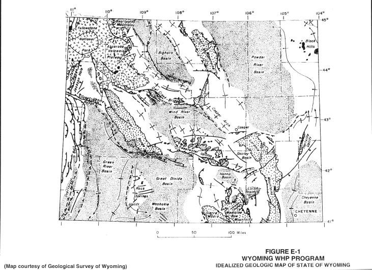
The asymmetrical structural basins of Wyoming are somewhat similar to one another in that surrounding tectonic elements are mountain uplifts cored by faults with up to several miles of structural offset. Precambrian igneous and metamorphic rocks are exposed as cores of the mountain uplifts with steeply-dipping Paleozoic sediments outcropping on their slopes. A variety of folds and faults can be found in the basin interiors. The principal anomaly to the structural style of the basins is the Overthrust Belt in the southwest corner of the state where a thick block of sedimentary rocks has been thrust eastward into the Green River Basin along low angle faults.
Virtually all of the stratigraphic units in Wyoming basins play a hydrogeologic role either as a major aquifer, a minor aquifer or a confining layer, which separate deep and shallow aquifer systems. Principal recharge of the deeper aquifers is from basin margin outcrop zones, whereas shallower ones receive recharge from outcrop areas, infiltration and vertical leakage from adjacent aquifers.
In most basins, hydrostratigraphic systems have been defined as water-bearing units consisting of possibly several formations. They are commonly adjacent units which have similar areal extent, hydraulic properties, water quality and are not separated by areally extensive confining units. Thick sequences of shales and siltstones usually separate the Paleozoic from the shallower Mesozoic and Tertiary aquifer systems. Exploitation of the deeper systems, particularly those with overlying highly productive aquifers, may limit the development of deeply buried production in the foreseeable future.
Rather than repeat the information prepared on the individual Wyoming Basins by the Wyoming Water Research Institute (Water Resource Center), the key reference and important aquifers are summarized by individual basin:
Powder River Basin:
Feathers, K. R., Libra, R., and Stephenson, T. R, 1980, Occurrence and Characteristics of Ground Water in the Powder River Basin, Wyoming: University of Wyoming Water Resources Research Institute report to U.S. Environmental Protection Agency, Vol. I-A and I-B (1981), 203 pp., 8 plates.
Major aquifers identified within the Powder River Basin:
Denver-Julesburg Basin:
Libra, Robert D., Collentine, M., and Feathers, K. R., 1981, Occurrence and Characteristics of Ground Water in the Denver-Julesburg Basin, Wyoming: University of Wyoming Water Resources Research Institute report to U.S. Environmental Protection Agency, Vol. VII-A and VII-B, 101 pp., 8 plates.
Major aquifers identified within the Denver-Julesburg Basin:
Bighorn Basin:
Libra, R., Doremus, D., and Goodwin, C., 1981, Occurrence and Characteristics of Ground Water in the Bighorn Basin, Wyoming: University of Wyoming Water Resources Research Institute report to U.S. Environmental Protection Agency, Vol. II-A and II-B, 104 pp., 5 plates.
Major aquifers identified within the Bighorn Basin:
Wind River Basin:
Richter, H. R., 1981, Occurrence and Characteristics of Ground Water in the Wind River Basin, Wyoming: University of Wyoming Water Resources Research Institute report to U.S. Environmental Protection Agency, Vol. IV-A and IV-B, 149 pp., 11 plates.
Major aquifers identified within the Wind River Basin:
Green River Basin and Overthrust Belt:
Ahern, J., Collentine, M, and Cooke, S., 1981, Occurrence and Characteristics of Ground Water in the Green River Basin and Overthrust Belt, Wyoming: University of Wyoming Water Resources Research Institute report to U.S. Environmental Protection Agency, Vol. V-A and V-B, 123 pp., 6 plates.
Major aquifers identified within the Green River Basin and Overthrust Belt:
Great Divide and Washakie Basins:
Collentine, M., Libra, R., Feathers, K. R., and Hamden L., 1981, Occurrence and Characteristics of Ground Water in the Great Divide and Washakie Basins, Wyoming: University of Wyoming Water Resources Research Institute report to U.S. Environmental Protection Agency, Vol. VI-A and VI-B, 112 pp., 10 plates.
Major aquifers identified within the Great Divide and Washakie Basins:
Laramie, Shirley and Hanna Basins:
Richter, H. R., 1981, Occurrence and Characteristics of Ground Water in the Laramie, Shirley, and Hanna Basins, Wyoming: University of Wyoming Water Resources Research Institute report to U.S. Environmental Protection Agency, Vol. III-A and III-B, 117 pp., 6 plates.
Major aquifers identified within the Laramie, Shirley, and Hanna Basins:
Sections
1 |
2 |
3 |
4 |
5 |
6 |
7 |
8
Appendices
A |
B |
C |
D |
E |
F |
G |
H |
I |
J |
K |
L |
M |
N |
O |
P |
Q |
R
Wellhead Protection Program Guidance Document Contents
Wyoming Department of Environmental Quality