The Environmental Protection Agency (EPA) has recognized a wide variety of techniques to determine WHPAs ranging from very simple non-analytical methods to complex numerical transport models (see EPA, 1993, Guidelines for Delineation of Wellhead Protection Areas, EPA-440/5-93-001). According to Hasfurther and others (1992), selection of these methods is based on user expertise, available resources, existing and field collected data, and the desired degree of confidence in meeting protection goals.
The delineation method(s) chosen in establishing a WHP plan will determine the type and quantity of data required for delineation.
The techniques which EPA has identified for delineation of WHPAs are:
These methods are listed generally in order of increasing complexity (i.e. sophistication) and not all of these methods may be applicable in every case. Hasfurther and others (1992) have outlined the limitations and strengths of each method and the differing amounts of data required to implement each method as described below.
The Arbitrary Fixed Radius, Calculated Fixed Radius, Hydrogeologic Mapping and Analytical Models methodologies have been adopted by the Wyoming Wellhead Protection Advisory Committee for use in delineating Wellhead Protection Areas (WHPAs) in Wyoming.
Arbitrary Fixed Radius (AFR):
The AFR method sets a fixed distance from a well, spring or tunnel, circumscribing a zone of equal distance around the well. It is used to define Zone 1 (Accident Prevention Zone) for wells completed in all types of aquifers (i.e. unconfined, semi-confined and confined) and flow conditions (i.e. diffuse and/or conduit flow). The AFR method is simple to apply and normally inexpensive.
As the name implies, the AFR technique is not based on in-depth knowledge of aquifer properties or well characteristics, but rather considers existing regulatory drinking water supply set-back distances to establish the threshold for Zone 1. This gives the technique its virtue (simplicity), and its weakness (it may or may not afford adequate protection, resulting in either over-protection or under-protection of the drinking water supply). Since the AFR method is based on limited scientific criteria, the method has a degree of uncertainty attached to it.
Calculated Fixed Radius (CFR):
The CFR method is a relatively simplistic method that can be applied to many sources (i.e. wells, springs, tunnels) and is used to determine the circular areas (around the source) through which groundwater will travel over some period of time. The travel time of groundwater from the edge of the circle to the source well is dependent on the radius of the circle.
CFR is an appropriate method to use when groundwater flow to the well, spring or tunnel can be characterized as ‘porous’ or ‘diffuse’, as opposed to ‘conduit’ flow. Use Table II-1 (Section II of Wyoming’s Wellhead Protection Guidance Document) to first determine if ‘conduit’ flow conditions prevail; apply the CFR equation (Appendix D, Table D-1) to determine the 2 year and 5 year Time-of-Travel radii if ‘porous’ or ‘diffuse’ flow is confirmed when following Table II-1. If ‘conduit’ flow is confirmed, refer to Table II-2 (Section II of Wyoming’s Wellhead Protection Guidance Document) for instruction.
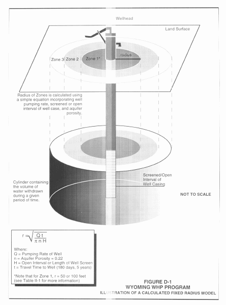
The CFR technique establishes a cylinder down into the aquifer where the radius of the cylinder is based on the Time of Travel (TOT) to the well; Table II-2 in Section II of this document establishes minimum TOT criteria (i.e. 2 years and 5 years) for using the CFR method to delineate Zones 2 and Zone 3 of the WHPA when porous or diffuse flow types prevail. TOT is an operationally defined measure of the rate of groundwater flow to the well, wellfield, spring or tunnel. The method is called the "Calculated Fixed Radius" (CFR) method because the area it describes is a circle, which has an equal radius in all directions. The radius is the distance from the well to a point where groundwater (and contaminant) travel time to the well is 2 years (or 5 years). Input data requirements are limited, consisting of the pumping rate, open (screened interval) of the well, porosity of the aquifer, and the selected TOT.
The CFR technique may not provide sufficient protection for the well-field. While it does take some aquifer properties into account, its tendency to generalize leads to errors, especially where the subsurface geology is markedly heterogeneous. Wyoming aquifers are frequently very heterogeneous, even on a relatively small geographic scale. An alluvial aquifer usually draws its water from alluvial type sediments which are often laced with pockets of cobbles, silt, and clay and may provide preferential flow paths or act as barriers to flow. Applying the CFR technique to wells completed in alluvium may not completely protect the wellfield from contamination arising from surface activity. For this reason, a Factor of Safety (F.S.) is incorporated in the CFR technique. Figure D-1 illustrates the CFR Method and Table D-1 provides the CFR equation and definitions of the required input data, including default values and Factors of Safety to be used for delineating Zones 2 and 3. An example of calculating the annual average pumping rate for a well follows Table D-1.
The 2 year (Zone 2) and 5 year (Zone 3) radii should be plotted, together with Zone 1, on a base map that shows major landmarks and topography. A 7 1/2 minute U.S. Geological Survey topographic map is generally acceptable. This is a map with a map scale of 24,000:1 or approximately 2.5 inches per mile. A map with a larger scale (3 to 4 inches per mile) is preferable in order to locate and identify potential contaminant sources that will be added to the map.
|
Calculated Fixed Radius Equation: |
|
|
rmin |
Radius of Zones 2 (and 3) measured from the well (in feet). |
|
Q |
Annual average pumping rate in gallons per year. Calculate or estimate as accurately as possible; should not be less than 5,000,000 gallons/year. |
|
t |
Time-of-Travel = 2 years for Zone 2; 5 years for Zone 3 |
|
n |
Porosity (Ratio of pore volume in aquifer to total volume) Use actual value if known. If aquifer lithology is known, but not porosity, use: |
|
H |
Screened or perforated interval(1) of well (feet). Actual Length, or 10 feet. |
|
pi |
pi = 3.1416 |
|
7.48 |
Conversion factor: Gallons to ft3. |
|
F.S. |
Factor of Safety: (to provide ‘Buffer Zone’) = 1.3 (when all values are known) = 1.5 (when one or more values is not known) |
1
"Screened Interval" refers to the length of screening or perforation in the well through which water is pumped from the aquifer. If there is more than one screened interval, add the lengths together and use the sum for this value. For an unscreened well, the equivalent term is "Open Interval". This information may be available on the well log, the State Engineers’ Office Statement of Completion, geologic or engineering reports. It is possible that the well has no screened (open) interval. If this is the case, or if you are unable to obtain this information, or for springs and tunnels, use a value of 10 feet.Example Calculation: Annual Average Pumping Rate
Use water meter data to perform this calculation if your source is metered. If your source is not metered, you will have to estimate your annual water volume (gal/year). If you know your pumping rate in gallons per minute (gpm) you can estimate annual usage in the following manner:
gal/min. x 60 min/hr x hr/day x day/year = gal/year
The next best method would be to substitute the value for pump capacity in place of pumping rate to estimate annual usage.
A third alternative would be to estimate your annual pumping based on the number of service connections on your system. For planning purposes, WDEQ/WQD considers 400 gallons a day per connection to be an average rate of consumption. This method works best for small community systems with single primary sources. With this method, the calculation would be:
|
|
# of service connections |
X 400 Gallons |
X Average use |
= Estimated average pumping rate per year |
|
50 |
X 400 |
X 365 days / year |
= 7,300,000 gallons / year |
Simplified Variable Shapes (SVS):
As detailed in Guidelines for Delineation of Wellhead Protection Areas (EPA-440/5-93-001), the SVS procedure involves generating a set of shapes that represent an array of hydrogeologic and pumping conditions. The variable shapes are calculated by computing the distance to downgradient and lateral extent of the groundwater flow boundaries around a pumping well according to analytical equations such as the uniform flow equations. The appropriate shape is then selected for the hydrogeologic and pumping conditions matching or similar to those found at the wellhead, and the shape is oriented around the well according to the groundwater flow patterns. A TOT or flow-system boundary criterion then determines the upgradient extent of the WHPA. The method is fairly easy to apply and requires little sophistication on the part of the modeler once the shapes have been defined. Data input is only slightly more involved than the CFR with the additional account of basic hydrogeologic parameters.
Where reasonable estimates of the hydraulic conductivity and hydraulic gradient can be determined (such as from median or conservative values cited in the literature, and generalized, regional potentiometric surface maps) a slightly more sophisticated method (Figure D-2) than the CFR may be employed. This "Modified Simplified Variable Shapes" method is particularly suitable for rural, non-community PWSs where site-specific data is limited, but regional or generalized information is available. The principle behind this method is in providing a factor of safety or buffer zone around what would be a good assessment of a WHPA if the data were more accurate, detailed, and reliable. For instance, in delineating a WHPA using the uniform flow equations (see Analytical Models below), the ZOC may be interpreted as a long, narrow band upgradient from the well. However, if the hydraulic gradient used in this delineation is over-estimated, the ZOC should be more circular and include more of the downgradient and lateral regions. In fact, as the hydraulic gradient goes to zero (stagnant groundwater), the CFR best estimates the ZOC. The Modified Simplified Variable Shapes method thus accounts for under-estimated hydraulic gradients by including a buffer zone in the upgradient direction, over-estimated hydraulic gradients by including a buffer zone in the downgradient direction, and poorly estimated flow lines by including a buffer zone defined by extending the region out 250 feet for every 1000 feet upgradient from the CFR. These buffer zones also serve as a factor of safety given uncertainty in the hydraulic conductivity value.
This method does not adequately represent aquifers with substantial hydrogeologic variability (heterogeneity) and does not take into account hydrologic boundaries such as irrigation canals, lakes, or streams. As previously described, flow in many Wyoming aquifers is affected by geologic and hydrologic boundary conditions. For example, the hydrology of some Wyoming community’s water supplies is influenced by the irrigation canals upgradient and a major river downgradient. The degree of influence of these boundaries may vary seasonally as the water levels from these features change. Where hydrologic boundaries may exist, Hydrogeologic Mapping and/or Field Test Data should be employed to and applied to appropriately establish Zones 2 and 3 of the WHPA.
To delineate a WHPA using the Modified Simplified Variable Shape method:
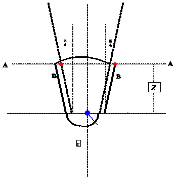
1) Draw a circle around the well using the Calculated Fixed Radius method (see Fig. D-1):
![]()
2) Draw a centerline though the well in the up-gradient direction of flow to determine the approximate distance of travel from the well ("z") using
![]()
|
Equation Constants |
Description |
|
n |
Porosity (Ratio of pore volume in aquifer to total volume) Use actual value if known. If aquifer lithology is known, but not porosity, use: |
|
K |
Hydraulic Conductivity |
|
I |
Hydraulic Gradient |
|
t |
Time-of-Travel = 2 years for Zone 2; 5 years for Zone 3 |
3) Draw a line perpendicular to the centerline at a distance ‘z’ from the centerpoint; label this line A-A’
4) Draw two lines tangent to the circle and parallel to the centerline. Where these cross line A-A’, measure outward a distance z/4; show as points B and B’.
5) Draw tangent lines from B and B’ to the circle.
6) Using the well as the centerpoint draw as arc from B to B’. (Hydrologic boundaries, when present, may provide this up-gradient boundary)
Analytical Models (AM):
The AM approach uses well established hydrologic equations to model groundwater flow and pollutant transport. A host of such analytical equations are available. The equations are generally fairly simple to solve but require a number of input hydrologic parameters which are generally assumed to be homogeneous throughout the saturated depth of the aquifer. This method tailors the results to a specific site through the use of the input parameters and, thus, can achieve considerable accuracy at a modest cost. Again, assumed subsurface uniformity may be a problem.
EPA’s guidance document "Delineation of Wellhead Protection Areas in Fractured Rocks" contains good descriptions of established hydrologic equations such as the Uniform Flow Equation and TOT calculations based on groundwater velocity. These equations can be used to delineate WHPAs that are more sophisticated, accurate, and defensible than WHPAs delineated by the CFR method.
Despite the increase of accuracy and defensibility, there is always some level of uncertainty involved. This is especially true where analytical equations and models derive long and narrow WHPAs which have a high sensitivity to the position of the potentiometric contours. From the perspective of implementation, there is a significant problem with a narrow WHPA because a relatively small error in the potentiometric map can result in a major shift in the ZOC. Therefore, a factor of safety or "buffer zone" around WHPAs delineated by analytical equations and models is, again, a practice that is strongly encouraged. For example, a buffer zone may extend outward from the mapped ZOC boundary by 250 feet for every 1000 feet of distance upgradient from the well.
What follows is a list and brief discussion of analytical and semi-analytical computer software developed by EPA which uses hydraulic and groundwater flow equations to model WHPAs based upon time-of-travel criteria. Sources and contacts for additional information (including WHPA and WhAEM software and user guides) available for use in completing WHPA delineations and Delineation Reports are provided in Appendix C.
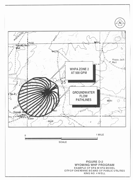
WHPA, version 2.2, is a semi-analytical groundwater flow model that consists of four computational modules designed to delineate WHPAs. This model was developed for the EPA Office of Groundwater Protection to assist communities in delineation of WHPAs. WHPA is thought to be an appropriate technique for many situations where the contaminant of interest is conservative. In other words, groundwater flow approximates solute movement in an unconfined, shallow aquifer. An example of the output from WHPA, version 2.2 for one of the wells serving the City of Cheyenne (which taps the Ogallala aquifer) is depicted on Figure D-2. Three of the modules calculate capture zones for two-dimensional, steady state groundwater flow. The fourth module, called Monte Carlo, performs an uncertainty analysis of the delineated capture zone and is not individually discussed herein. The four modules are: (1) RESSQC, (2) the Multiple Well Capture Zone module (MWCAP), (3) the General Particle Tracking module (GPTRAC), and (4) the Monte Carlo module (Montec).
GPTRAC Option. The General Particle Tracking module (GPTRAC) contains two components, a semi-analytical and a numerical option. The numerical option is designed to be used as a post processor for numerical groundwater flow models. This option requires as input the hydraulic heads at nodes of the rectangular grid system. The head information is utilized to calculate x and y direction velocity components of groundwater flow at the edges of each grid block. Numerical integration of velocity components with respect to time and space is then applied to describe capture zones and streamlines.
The primary advantage of the numerical option is that a heterogeneous aquifer with complex boundary conditions can be considered. This method allows the aquifer to be divided into many zones with varying porosity, saturated thickness, and transmissivity in both the x and y directions. The numerical option delineates capture zones around pumping wells for steady state groundwater flow. Consequently, some assumptions are necessary as to the average daily pumping rates of municipal wells.
One shortcoming of this module is that it sometimes fails to produce reasonable results for smaller time-related capture zones. For simulation times less than three years, the capture zone pathlines sometimes do not conform to the regional hydraulic gradient. The EPA Office of Groundwater Protection recommends time periods of 10 to 25 years when determining time-related capture zones. It is necessary with this method to balance, when considering the lengths of simulation periods, the limited size of the study area and constraints of the model.
In conclusion, the GPTRAC numerical module appears to be the most versatile method. It is capable of delineating WHPAs for a heterogeneous aquifer(s) with a complex flow system. This module is limited only by the numerical model used to obtain the potentiometric head map.
The semi-analytical option assumes a system of pumping and injection wells that fully penetrate a homogeneous aquifer under steady state conditions. A constant-head or no-flow boundary can be specified along any edge of the study area. Well interferences are accounted
for by superposition of solutions. Specifically, the input requirements include: (1) the regional hydraulic gradient, (2) the direction of groundwater flow, (3) porosity, (4) saturated thickness, and (5) transmissivity, etc. From the input information, it is evident that this module is best suited for a one-directional, homogeneous flow system with simple boundary conditions and a constant hydraulic gradient.
RESSQC Option. RESSQC is used to delineate time-related capture zones for a steady-state flow system including both injection and pumping wells in a homogeneous aquifer. Stream and barrier boundaries can be implemented using image well theory. Well interferences arising in a multiple well system are determined by superposition. The primary disadvantage of this method is that aquifer flow parameters such as, hydraulic gradient and flow direction, are held as constants. The impermeable zones in a study area have to be simulated with image wells.
MWCAP Option. The Multiple Well Capture Zone module (MWCAP) is designed to delineate time-related capture zones for steady-state pumping wells in a homogeneous aquifer. Streams or boundaries can be simulated and are assumed to be linear and fully penetrating. Well interferences are neglected; each well is assumed to operate independently.
This module provides a little more flexibility, in some ways, than the RESSQC module discussed previously. Input parameters can be specified for each well rather than for the entire aquifer. Input requirements for each well include: (1) regional hydraulic gradient, (2) flow direction, (3) conductivity, (4) saturated thickness, (5) porosity, and (6) the boundary type and the perpendicular distance from the well.
WhAEM, also developed by EPA, has superseded and improves upon WHPA 2.2 and is an analytical groundwater model developed to determine time-of-travel capture zones in relatively simple hydrological settings for either confined or unconfined aquifers. WhAEM consists of two executables: the preprocessor GAEP, and the flow model CZAEM. GAEP is designed to simplify the procedures for getting data into a groundwater model; specifically it facilitates the interactive process of groundwater flow modeling that precedes capture zone delineation. WhAEM can handle fairly realistic boundary conditions such as streams, lakes and aquifer recharge due to precipitation.
The WHPA modeler must have some familiarity with the site being delineated and be able to use sound judgment in selecting input information from the range of hydrologic values likely to be available. Costs associated with obtaining input data are about the same as for the Simplified Variable Shapes (SVS) technique.
Hydrogeologic Mapping (HM):
HM identifies the physical and hydrologic features that control groundwater flow within an aquifer system. Included within this method is Flow-System Mapping which delineates the ZOC for a well, spring, or tunnel by identifying flow system boundaries. Physical boundaries to groundwater flow can include the geologic contacts that form the limits of the aquifer, structural features such as fault-block walls or zones of fracturing, and topographic features that may function as groundwater divides. Hydrologic features, including rivers, canals, and lakes can also function as flow-system boundaries.
Vulnerability Mapping is another HM technique which identifies areas particularly vulnerable to groundwater contamination. Such areas include shallow or exposed bedrock, permeable soils, faults zones, fracture zones, and karst features such as solution cavities and sinkholes. For the purposes of wellhead protection, it is most important to find the vulnerable areas where contaminants potentially released at the surface may be most likely transported to the water supply. Vulnerability mapping does not necessarily produce a ZOC for a given well; used in combination with flow-system mapping however, it is an excellent method for assessing the susceptibility of more specific regions within the flow-system boundaries to groundwater contamination.
Aquifer ‘sensitivity’ maps are available for many Wyoming counties and are excellent tools for identifying areas within WHPAs where the ‘uppermost’ aquifer is most ‘sensitive’, or susceptible to contamination from a release of a contaminant at the surface. Generally speaking, ‘sensitive’ areas within WHPAs may be considered to be vulnerable to contamination unless adequate protection measures (see Section IV of Wyoming’s Wellhead Protection Guidance Document) are in place.
HM works well in regions where subsurface geology is variable, such as in fractured rocks, and where near surface boundaries occur. EPA (see EPA, 1991, Delineation of Wellhead Protection Areas in Fractured Rocks, EPA-570/9-91-009) suggests the flow-system boundary criterion is an excellent approach to use when hydrologic boundaries are close to a well, spring or tunnel; however, when boundaries are distant, EPA (1991) indicates the WHPA may be too large to manage effectively.
The information required for hydrogeologic mapping is available for most of the populated areas of the state. These include topographic maps, aerial photos, geologic and hydrogeologic maps and reports, well logs, geologic field reconnaissance data, and aquifer test data. Topographic maps suggest the location of groundwater divides in unconfined aquifers. Aerial photos can be used to locate faults and fracture traces; infrared photos identify riparian vegetation that can indicate the extent of an unconfined alluvial aquifer. Hydrogeologic maps and reports contain information on aquifer parameters such as gradient, transmissivity, direction of flow and hydraulic conductivity. Geologic reports show outcrop areas and strike and dip of aquifer formations; they also show the location of faults, synclines and anticlines. Well logs contain a description of aquifer materials, evidence of fracturing, well completion, pump test, depth of the well and static water level.
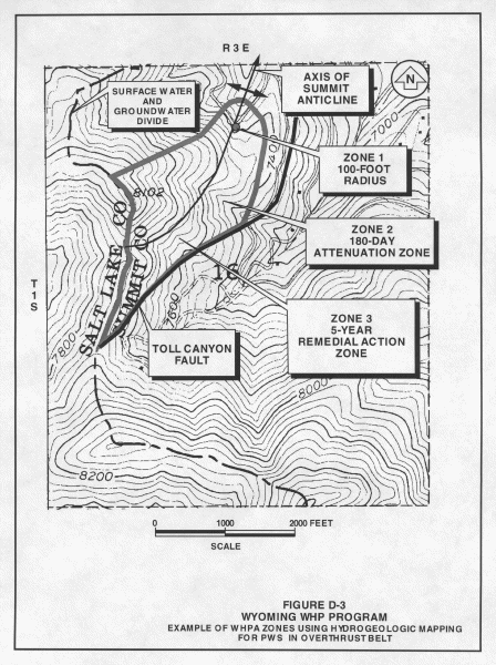
Professional geologic/hydrogeologic training and experience is required on the part of the investigator to interpret all mapping data. For example, hydrogeologic investigations in fractured rock aquifers typically requires two approaches to fracture characterization. The discrete approach requires investigating each individual fracture. Conversely, the continuum approach assumes the fractured medium approaches a porous medium at some working scale. The mapping data may not be sufficiently detailed to accurately reflect the subsurface conditions. Costs accrued in obtaining required hydrologic knowledge will vary with the complexity of the subsurface lithology. An example of a WHPA delineated using HM is depicted on Figure D-3 for a PWS in the Overthrust Belt area near southwestern Wyoming.
Aquifer Field Tests also can provide information useful for the characterization of aquifer (and well) flow systems and boundary conditions. While not exclusively a subset of the Hydrogeologic Mapping method, scientists and engineers can often delineate WHPAs from field test data and observations. For further descriptions and additional information on these types of tests and the results they produce, please refer to the EPA document referenced above.
Numerical Models (NM):
Numerical models allow intricate subsurface conditions and hydrologic features to be represented with a fair degree of accuracy. Some models may use analytical models to depict contaminant transport, affixing the analytical transport model to the numerical flow model which includes advection and dispersion processes within the aquifer. The models demand a considerable amount of input information, particularly if they have analytical components. If the model is to be accurate, the number of grid cells needs to be numerous in regions where strong changes are occurring. This increases the overall cost of the modeling and may require the use of a mainframe or larger microcomputer. The modeler must be experienced in its use and be able to recognize the model's limitations and quirks. Generally, communities in Wyoming do not have people on staff with sufficient expertise to readily and accurately apply the NM technique, and an outside consultant would generally be needed in order to carry out numerical WHPA delineation studies.
WHPA Version 2.2: GPTRAC - Numerical Option. The General Particle Tracking module (GPTRAC) contains two components, a semi-analytical and a numerical option. The numerical option is designed to be used as a post processor for numerical groundwater flow models. This option requires as input the hydraulic heads at nodes of the rectangular grid system. The head information is utilized to calculate x and y direction velocity components of groundwater flow at the edges of each grid block. Numerical integration of velocity components with respect to time and space is then applied to describe capture zones and streamlines.
The primary advantage of the numerical option is that a heterogeneous aquifer with complex boundary conditions can be considered. This method allows the aquifer to be divided into many zones with varying porosity, saturated thickness, and transmissivity in both the x and y directions. The numerical option delineates capture zones around pumping wells for steady state groundwater flow. Consequently, some assumptions are necessary as to the average daily pumping rates of municipal wells.
One shortcoming of this module is that it sometimes fails to produce reasonable results for smaller time-related capture zones. For simulation times less than three years, the capture zone pathlines sometimes do not conform to the regional hydraulic gradient. The EPA Office of Groundwater Protection recommends time periods of 10 to 25 years when determining time-related capture zones. It is necessary with this method to balance, when considering the lengths of simulation periods, the limited size of the study area and constraints of the model.
In conclusion, the GPTRAC numerical module appears to be the most versatile method. It is capable of delineating WHPAs for a heterogeneous aquifer(s) with a complex flow system. This module is limited only by the numerical model used to obtain the potentiometric head map.
Other commonly used numerical models include MODFLOW, FLOWPATH, PLASM and SUTRA.