Water Resources Data System & State Climate Office
Water Resources Data System & State Climate Office
Water Resources Data System & State Climate Office
WRDS/SCO may be working remotely so there could be a slight delay returning phone calls. Please email wrds@uwyo.edu if you are in need of information and we will respond as soon as possible
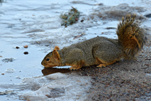
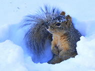
Snow
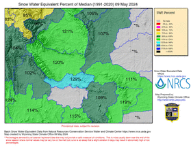
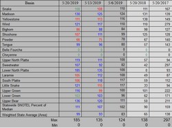
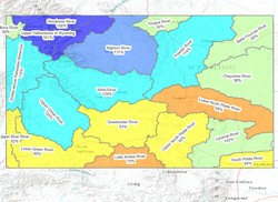
Snow Water Equivalent by Basin
Color-coded map of Daily Snow Water Equivalent (SWE) by Basin
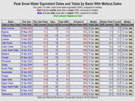
Basin Peak SWE and Meltout Dates
Dates and Values of Peak Snow Water Equivalent with Meltout Dates by Basin
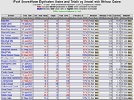
Snotel Peak SWE and Meltout Dates
Dates and Values of Peak Snow Water Equivalent with Meltout Dates by Snotel
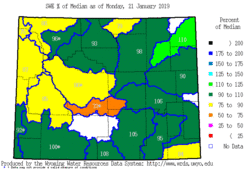
Monday Morning Snow Report
Summary Table of NRCS Basin Snow Water Equivalent as a percent of normal
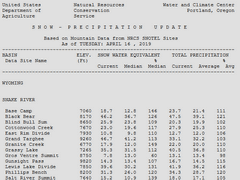
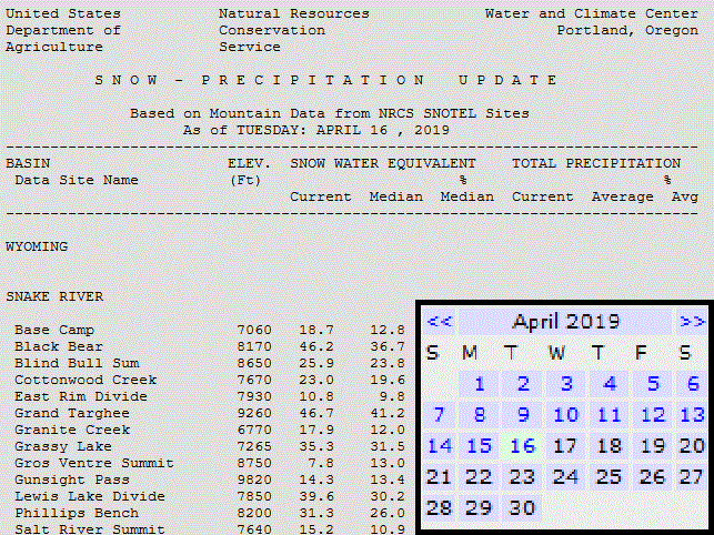
Snow Precipitation Update (WY)
Daily NRCS reports on individual SNOTEL Site current and average
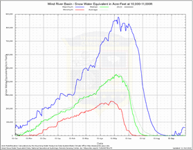
Snow Water Equivalent Volume by Elevation
Volumes in acre-feet at 9 different elevations in each Wyoming basin
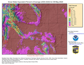
Modeled Snow Water Equivalent
Modeled Snow Water Equivalent as percent of average
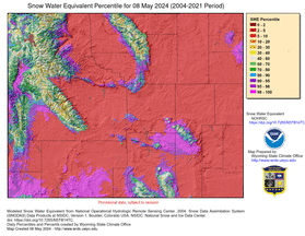
Modeled Snow Water Equivalent
Modeled Snow Water Equivalent as percentile
Historical Snow Precipitation Updates
Archived Daily NRCS reports on individual SNOTEL Site current & average snowpack (1997-Present)
Historical Maps of Snow Water Equivalent
Archived Map of Daily Snow Water Equivalent (SWE) by Basin (2013-Current)
Snow Water Equivalent by Basin
Map of Daily Snow Water Equivalent (SWE) by Basin
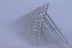
Wind-Blown Snow
Information on managing drifting snow
Snow Precipitation Update (Surrounding States)
Surrounding states Daily NRCS reports on individual SNOTEL Site current and average snowpack values
Basin Outlook Reports
Monthly Reports on Snowpack produced by NRCS (1997 to current)
Water Supply Outlook
Map of forecasted water supply in major Wyoming River's (created by NRCS, NOAA)
Snow Depth at Select Wyoming Sites
Current SNOTEL Snow Depth (NRCS Sites)
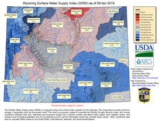
Surface Water Supply Index
Index map of surface water supplies calculated using reservoir storage and forecasted runoff
CoCoRaHS Page
Wyoming Volunteers will receive a free 4" diameter rain gauge and a login account to enter their observations.
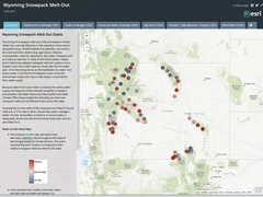
Storymap of SnoTel Sites Meltout
Story Map containing links and information on current and historical Wyoming Snowpack Melt-Out Timing