Water Resources Data System & State Climate Office
Water Resources Data System & State Climate Office
Water Resources Data System & State Climate Office


Wind Roses
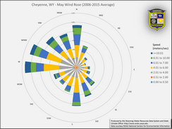 Wind roses are graphics that depict how the direction and speed of wind is distributed about a compass for a
particular location. We show monthly wind roses for each of the stations below. The roses were created to
show the distribution using wind data for the 2006 to 2015 (10-year) period by month. If you wish to view
wind roses for specific months, see Wind Roses for Individual Months.
Wind roses are graphics that depict how the direction and speed of wind is distributed about a compass for a
particular location. We show monthly wind roses for each of the stations below. The roses were created to
show the distribution using wind data for the 2006 to 2015 (10-year) period by month. If you wish to view
wind roses for specific months, see Wind Roses for Individual Months.