| |
 |
|
| ||||||||||||
Drought Impacts and Outlook Summaries - March 2017View this Summary as a PDF
Highlights for the State
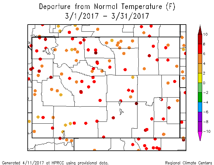
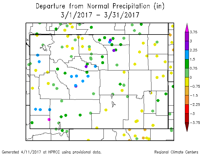
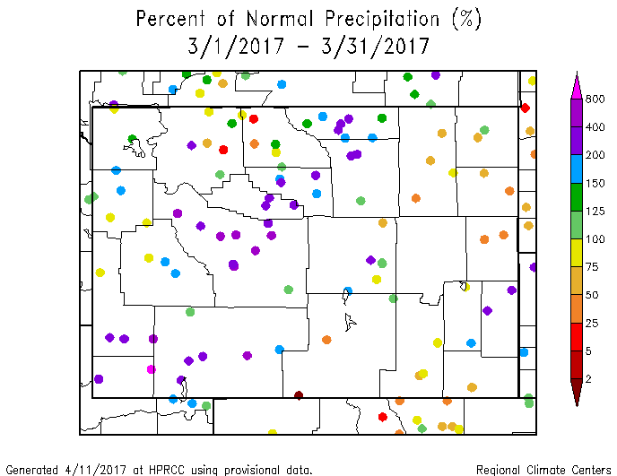
April temperatures, so far, have been well-above normal in the east. Stations in western Wyoming have been cooler than those in the east but most still have average temperatures that are above normal. For statewide precipitation, March was the 14th wettest of the last 123 years. Precipitation was much more varied across the state with CD 9 being the 4th wettest since 1894 and CD 7 being the 22nd driest (102nd wettest). The notably wet areas included CD 3, CD 9, southeastern CD 4, and western CD 5. April's precipitation (through the 12th) has been below normal in the northwest and southeast. The rest of the state has been above normal. This includes some helpful precipitation in the drought-impacted area in the northeast.
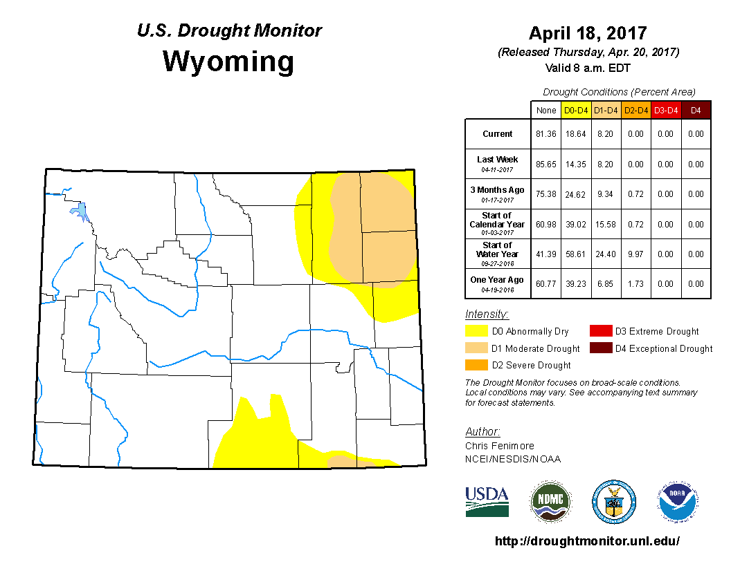
Drought
The areas of Moderate Drought (D1) in the northeast part of Niobrara County have been downgraded to D0. D1 in the very northeastern corner of Crook County has also been downgraded to the D0 category. In the south-central part of Wyoming (Carbon and western Albany counties) low precipitation amounts have warranted the westward expansion of the D0 there. Drought conditions in eastern Wyoming will likely persist for a while longer since the area has, until late, been receiving below-normal precipitation.
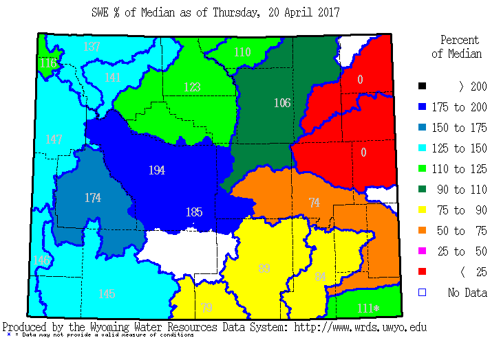
Snowpack
This high snowpack and the first weeks of spring runoff has already caused flooding, and there is high potential for more flooding in parts of the Wind, Upper Green, and Shoshone river basins. Snow pack products can be found at: http://www.wrds.uwyo.edu/sitemap.html Do you have drought impacts to report? We still need your on-the-ground reports and you can input them here: http://droughtreporter.unl.edu/submitreport/
Water Resources
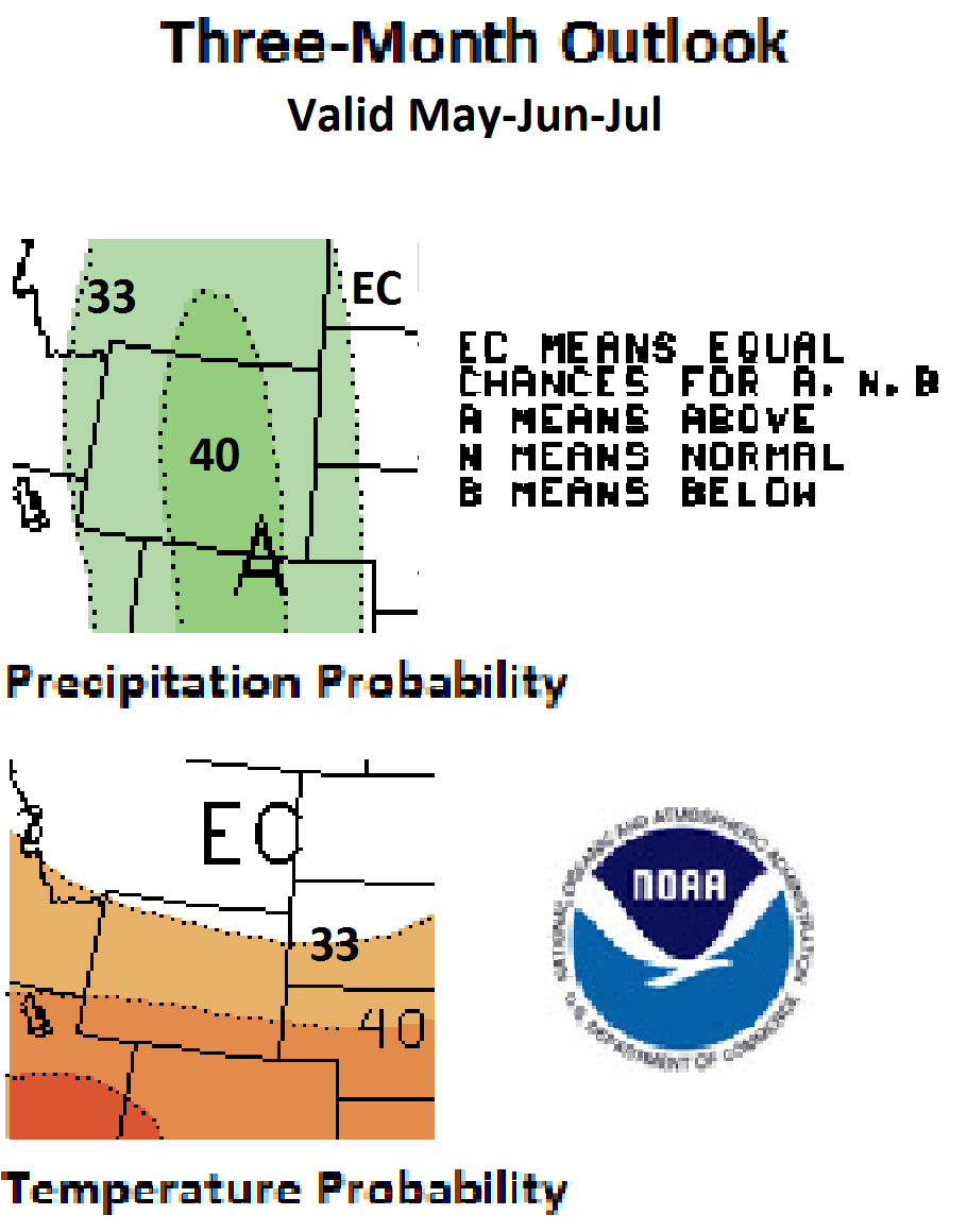
Weather and Climate Outlooks Looking at the May to July time frame, all but the very northern part of the state has elevated chances of above-normal temperature. The chances increase as one goes south. For precipitation, too, the entire state has odds favoring above-normal amounts, with the odds being a bit higher for the central region of Wyoming. For June through August, the pattern is somewhat similar for temperature but with the northeastern third of the state having even chances of above, below, or normal temperature. For the same time period, the entire state has better chances for above-normal precipitation with the odds higher for the western two-thirds. Looking at the July thru September outlook, all of Wyoming has elevated chances for above-normal temperatures and above-normal precipitation. Drought conditions are expected to persist in the northeast part of the state for a while longer. In the south-central parts of the state, D0 is expanding. The area is expected to have above-normal precipitation but, with above-normal temperatures also possible, the extent and intensity of drought there still could increase.
Heard around the State Washakie Co., Mar 25: Fruit trees have started budding out- which is too soon as night time temperatures are barely hovering above freezing. After the 3/4" rain on Thursday, things have greened up significantly. Park Co., Apr 9: I continue to see more birds; the robins are now back in significant numbers...I'm seeing new buds appear on the end of some of the trees in the neighborhood.
Partners
Stay Tuned and In Touch Live in or around the Wind River Indian Reservation? Check out the Wind River Indian Reservation and Surrounding Area Climate and Drought Summary at: WindRiverRes-Climate-Drought-Summary-Mar2017.html |
||||||||||||