 Climate ChangeClimate Change
There are three types of lies:
-Lies
-Damn Lies
-And Climate Statistics
-Mark Twain (paraphrased)
Just as the scalpel is an essential instrument for the surgeon, statistics is the tool of choice used by the climatologist. Sorting through the years of hourly and daily weather data in the search for a trend or recognizable weather pattern shift is a daunting task in which statistical methods may help to reveal evidence. The importance of finding order out of all this apparent chaos will in part help answer critical questions1, 2 about our survival as a species (e.g., how to adapt to climate change, modify the climate, or do nothing and perhaps perish as some have speculated). Are the much-debated claims for the cause of global warming (natural vs. human induced) really based on scientific facts that are verifiable with observed data?2a
Since the earth has been warming and cooling long before man first appeared on the scene 3 why has this issue dominated the headlines day after day?
As the earth's population increases, natural resources become more limited and the quality of life becomes more problematic.
If the earth begins to warm rapidly in this century, what are the consequences? Is there anything we can do to modify the climate to optimize our productivity, or do we just prepare as best we can for whatever the climate evolves into? Perhaps the interchangable use of the terms "climate change" (nature caused) and "global warming" (human caused) have clouded the debate. As many people are starting to realize, statistics cannot be used to prove or disprove anything but only to show a correlation and not a causality. This distinction is important and often is used to misrepresent findings. Facts are claimed as truth when they may be only possibilities. However, when used correctly, statistics at the very least can give researchers clues for which direction to focus their efforts for finding the best possible answers or solutions.
Because Wyoming is mostly rural with minimal contamination of its climate record, temperature and precipitation trends during the past 70 years have shown only the weakest indication of change. While there are hotter and colder, wetter and drier years, the short and long-term cycles have neutralized any trends. However, if we see that weather records begin to fall year after year or day after day, then one could expect a major climate change is underway.4 For example, if a weather station has 100 years of homogeneous observations, that is, no change to the station's location, instrumentation, or surroundings, a daily maximum or minimum record temperature could be expected to be broken on average about seven days during that year. Natural variation will cause this number to vary each year but should average about seven days over several years. Or for a given day, it would take 12,367 years for 10 new records to occur. During the first 10 years of record keeping approximately three new records will have occurred. However as the station's observations increase over time, it will become harder for new records to be established. This of course assumes that climate variation occurs as a normal probability distribution:
The n is the number of weather elements under consideration and N is the number of years of available weather data. More records will be established quicker if more weather elements are being considered.
This rule of thumb might work over several decades or centuries, but we know from the paleoclimate record dating back a billion years that climate undergoes significant changes throughout history, the most recent being the Last Ice Age.
Weather forecasting has come a long way with the era of satellite remote sensing and the use of dense surface weather station networks. With the introduction of the Next Generation Radar (NEXRAD, WSR-88D), Automated Surface Observing System (ASOS), and weather satellite atmospheric sounders, data availability and quality are improving.
We are beginning to understand the relationship with various atmospheric indices, such as El Niño Southern Oscillation (ENSO), perhaps the most famous one, and the Pacific Decadal Oscillation (PDO).4a While these events are more or less predictable several years in advance and we know in general what type of seasonal weather will occur, the ultimate cause for these regional and global weather pattern shifts are still not fully understood.
There are, however, weather events that are predictable almost to the hour (diurnal variation) or to the day (annual cycle) with remarkable regularity. Known in scientific literature as "weather singularities", these events have a known physical explanation. On a local scale, the land-lake breeze or mountain-valley breeze will occur when the temperature difference between the adjacent but dissimilar topography or geographical areas reach a known threshold that induces a localized circulation. On the regional scale, the monsoons over the southwest US occur when the summer land heats faster than the nearby ocean, thus inducing rising air that condenses over land. This effect is enhanced when moist air from the ocean is forced inland and up against mountain ranges. While these events occasionally fail to materialize on a fixed schedule, over the long-term they appear with a very high degree of repeatability, thus making their forecast very reliable.
To better understand the nature of climate, a brief discussion of the state's geography is required. In each of the succeeding chapters there is a general description of the climate element as it relates to Wyoming.
Wyoming's outstanding features are its majestic mountains and high plains. It has a land area of 97,914 square miles (ranks 9th in the US) with water area totals of 714 square miles (35th). Percent of land in rural areas totals 91.7% (9th), with 47.7% owned by the Federal Government (6th) and 6.2% owned by the State Government. Its mean elevation is about 6,700 feet above sea level (2nd) and even when the mountains are excluded, the average elevation over the southern part of the state is well over 6,000 feet, while much of the northern portion is approximately 2,500 feet lower. The lowest point of 3,125 feet is near the northeast corner where the Belle Fourche River crosses the State line into South Dakota. The highest point is Gannett Peak at 13,785 feet, which is part of the Wind River Range in the west-central portion. Since the mountain ranges lie in a general north-south direction they are perpendicular to the prevailing westerlies and provide effective barriers which force the air currents moving in from the Pacific Ocean to rise and drop much of their moisture along the western slopes. Wyoming is considered semiarid east of the mountains. There are several mountain ranges but the mountains themselves cover less area than the high plains. The topography and variations in elevation make it difficult to divide the state into homogeneous, climatological areas.
The Continental Divide splits the state from near the northwest corner to the center of the southern border. This leaves most of the drainage areas to the east. The run-off drains into three great river systems: the Columbia, the Colorado, and the Missouri.
The Snake, with its tributaries in the northwest, flows into the Columbia; the Green River drains most of the southwest portion and joins the Colorado; the Yellowstone, Wind River, Bighorn, Tongue, and Powder River drainage areas cover most of the northern portion flow northward into the Missouri. The Belle Fourche, Cheyenne, and Niobrara, covering the east-central portion flow eastward, while the Platte drains the southeast and flows eastward into Nebraska. There is a relatively small area along the southwest border that is drained by the Bear which flows into the Great Salt Lake(Figure 1.1). In the south-central portion west of Rawlins, there is an area called the Great Divide Basin. Part of this area is often referred to as the Red Desert .
There is no drainage from this basin and precipitation, which averages only seven to 10 inches annually, follows creek beds to ponds or small lakes where it either evaporates or percolates into the ground.
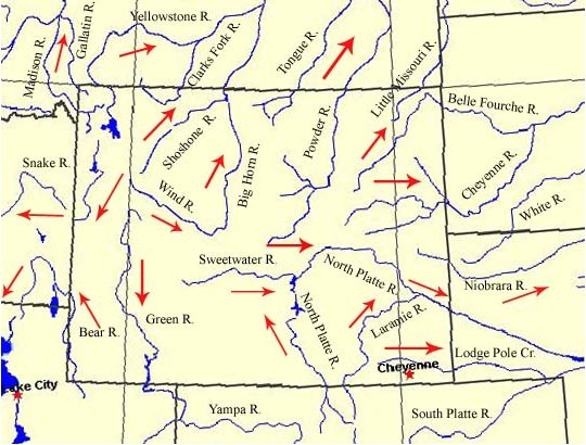
Figure 1. Major Wyoming rivers and stream flow direction
Snow accumulates to considerable depths in the high mountains and many of the streams fed by the melting snow furnish ample quantities of water for irrigation of thousands of acres of land. The snowmelt also furnishes water to generate electric power for industrial and domestic uses.
Rapid run-off from heavy rain during thunderstorms causes flash flooding on the headwater streams; the flooding is intensified when the time of these storms coincides with the melting of the snow pack. Considerable damage results when overflow occurs in the vicinity of urban communities situated near these streams.
As one climbs in altitude, the temperature will generally decrease by 5.5° F per 1,000 feet in dry air or 3.5° F per 1,000 feet in saturated air. This change is nearly equivalent to a move poleward of 300 miles. Since the average elevation in Wyoming is about 6,700 feet above sea-level, its annual temperature is nearly the same as a similar area near sea-level 2,000 miles north of the state. The same plant species would be expected in both locations if the available precipitation were similar. The timber line decreases in elevation by about 350 feet for every 100 miles north that one travels. Of course, seasonal variations in temperature occur because of the tilt of the earth's axis which causes the sun to appear lower or higher in the noontime sky. Also, when one moves to or from a specific latitude, the amount of heat received from the sun will vary.
Daily temperature usually peaks two to three hours after the sun reaches its highest point in the sky while the coldest temperatures occur just around sunrise. Maximum yearly temperatures usually occur around 10 July and the mimumim around 10 January. If winds persist over night and/or clouds dominate, temperatures will be warmer than if the winds are calm and the skies are clear. This happens because winds help mix warmer air that is aloft with cooler air nearer the surface. Clouds, on the other hand, tend to radiate heat back down to earth, acting as a blanket. Of course, after the passage of a cold front, colder air moves into an area through a process called advection, thus helping to cool the air at all levels.
Ecoregions are large areas of similar climate where ecosystems recur in predictable patterns. In Figure 1.1a., the ecoregions for Wyoming and vicinity is shown. Many federal agencies and private organizations use a system of land classification based on the ecoregion concept. Some of these include USDA Forest Service, U.S Geological Survey, U.S. Fish and Wildlife Service, The Nature Conservancy, and The Sierra Club. Projects include biodiversity analysis, landscape and regional level forest planning, and the study of mechanisms of forest disease.
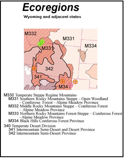
Figure 1.1a. Ecoregions
Recent reports from the Intergovernmental Panel on Climate Change (IPCC) indicate that several General Circulation Models (GCM) predict temperature increases greater than 6° F during the next 100 years due to increased greenhouse gas emissions (i.e., Carbon Dioxide, (CO2)). Wyoming (Figure 1.2) and the Northern High Plains have not experienced large annual changes in temperature or precipitation during the past five to six decades, with the exception of North Dakota (temperature) and central South Dakota (precipitation) despite increasing greenhouse gases in the atmosphere. Increased trends in precipitation along the coastal waters of the Gulf of Mexico and the eastern seaboard are attributable to an increase in tropical storm activity. Decreasing temperature over the southeast US is caused by increases in general cloud cover. Increases in temperature over the southwest US are caused by irrigation of desert lands.
Night time temperatures remain higher as a result of the introduction of additional water vapor into the lower atmosphere. Increasing temperature trends over the western third of the county are negated by the decreasing trends over the southeast US despite increasing urbanization (Figure 1.3). The GCM also predicts that with increasing temperatures, precipitation is expected to increase. These modeled forecasts have not been successful thus far when compared to actual observations for many locations around the US.
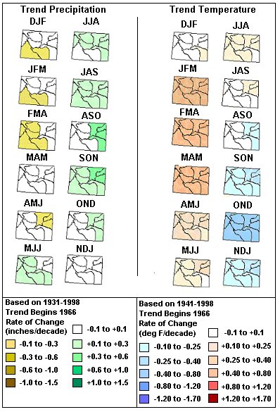
Figure 1.2. Wyoming decadal precipitation and temperature changes by three month running averages with trends since 1966 (courtesy of NOAA's Climate Prediction Center)
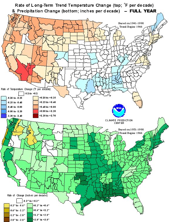
Figure 1.3. Annual temperature and precipitation decadal changes for the US (trends since 1966)6
Both water vapor and carbon dioxide are greenhouse gases. Both can warm the air. Warmer air can contain more water vapor than cooler air. For that reason, climate models incorporate a “positive feedback loop” between atmospheric carbon dioxide levels and atmospheric moisture content. The way the models see it, as the atmospheric concentration of CO2 increases it leads to warmer conditions, which lead to more water vapor in the air, which leads to even warmer conditions.
Remove the positive feedback from water vapor and an enhanced carbon dioxide concentration (on its own) results in the climate models’ projecting only about one-half to two-thirds the amount of warming they do when water vapor's positive feedback is included. But this doesn’t account for the fact that the water vapor feedback itself can be amplified by consequent changes in cloudiness.
High-level water vapor (and ice crystal) amounts have a major influence on planetary temperatures. Water vapor (and cirrus clouds) at this height have a net warming effect-they allow sunlight to readily pass through to the surface, yet they are also effective at absorbing heat emitted from the earth and atmosphere. Since radiosonde data are used to run climate models, these findings imply that the models are wrong in a fundamental way. For example, one method by which the climate models can generate high surface temperatures is to overestimate the amount of warming generated per unit increase in greenhouse gas levels.
Thus in order to better model climate, there is a fundamental need to know what the water vapor content is for the entire atmosphere. Recent technological advances using Global Positioning Satellites (signal delays) may help provide this valuable data.6a
A climate Normal is defined by convention as the arithmetic mean of a climatological element computed over three consecutive decades beginning with year one (e.g., 1971). Although an individual weather station's trends are useful for determining any signals of a climate change, a region such as any of Wyoming's 10 climate divisions (CD) (Figure 1.4) can perhaps better reveal if a individual station's trend is representative of any larger scale climate change.

Figure 1.4. Wyoming Climate Divisions
In Figure 1.5, Wyoming's climate division 1 (Yellowstone region) clearly shows a warming trend during the first three months of the year and a cooling trend during December. Annually, the temperature has increased 0.9° F for the past five Normal periods. Figure 1.6 shows the same Normal periods for precipitation.
Annually, the trend has decreased by more than an inch.7 When comparing average monthly temperature (Figure 1.7) and preciptation (Figure 1.8) for the period from 1931-2000, clearly western Wyoming (CD 1, 2, and 3) is cooler and northeast Wyoming (CD 5, 6, and 7) is the warmer region of the state. Climate division 2 is by far the wettest in the cooler season and CD 5, 6, and 7 are the wettest during the warmer season.
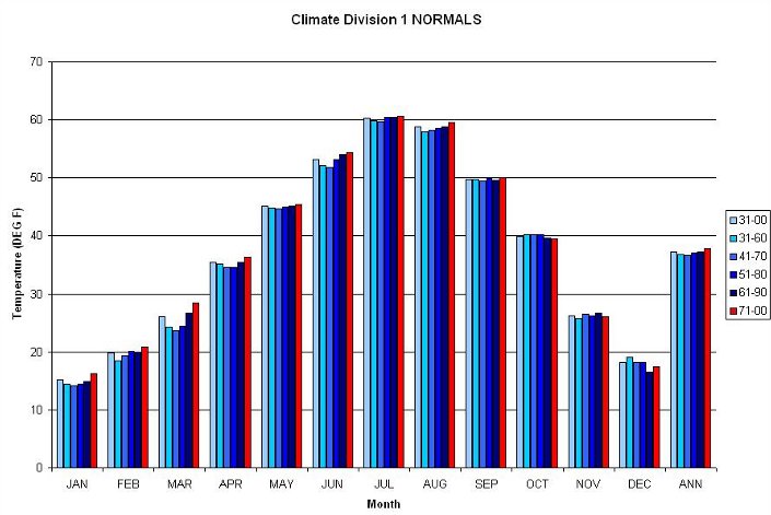
Figure 1.5. Wyoming Climate Division 1 (NW corner of the state) showing
the average temperatures from 1931-2000 and the last five climate Normals8
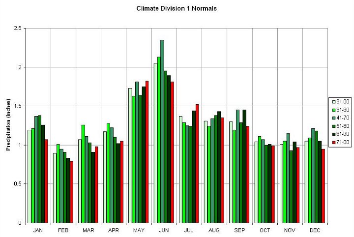
Figure 1.6. Same as Figure 1.5 except for
precipitation9
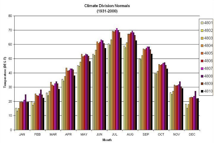
Figure 1.7. Monthly average temperatures for all 10 Wyoming Climate Divisions based on the period from 1931-2000 (5 Normal Periods)
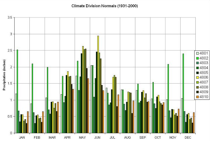
Figure 1.8. Same as Figure 1.7 except for precipitation
The discussion about the nature of climate change would not be complete without addressing whether the US Climate Reference Network has experienced any significant climate changes. These high quality weather stations are located so that the effects of urbanization or other land-use changes in the vicinity of these stations are held to a minimum. However, this has not always been successfully achieved. Some of these stations have been relocated over time and a correction factor to tie both locations to a similar climatology may have been incomplete. However, the goal of maintaining a homogeneous long-term climate record is paramount and is expected to improve with the employment of better weather sites in the near future.
Climate models imply that with global warming, whether natural or human induced, precipitation totals will increase over time. While locations such as Alta indicate that the models may be correct, the trend pattern is far from conclusive across Wyoming (Figure 1.9). The change in annual precipitation is based on linear regression statistics for 100 years. All stations have continuous records of at least 79 years as of 2000. Climate models also suggest that, with global warming, temperatures will increase over time, especially average minimum temperatures. In 1984, Rock Springs minimum average temperatures jumped over 10°F for some unknown reason, thus skewing the long-term trend. However, since there are a number of stations reporting a cooling trend for minimum averages(Figure 1.10), some kind of contamination of the records is suspected. The top number is the maximum temperature linear trend based on a 100-year period. All stations exceed 62 years of record length as of 2000, but all have several years when critical data were not availible, thus potentially resulting in erronous trends.
While the family of GCM's predictive capabilities are slowly improving, there are still significant hurdles to overcome. Namely improved spatial grid resolution horizontally and vertically, as well as a more thorough understanding of cloud parameterization. Improvements in computer technology is expected to drastically improve spatial resolution shortly. Cloud physics on the other hand is not well understood due to their dynamic nature. Their location, type, and water content are constantly changing due to external factors that are not easily quantified or accounted for. These factors make cloud modeling extremely difficult and inaccurate especially in terms of time. Cloud modeling would require accurate measurements in real time to keep up with the fluidity of a cloud life.
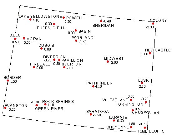
Figure 1.9. Historical Climate Network Stations precipitation trends. Values are in inches of change per century.
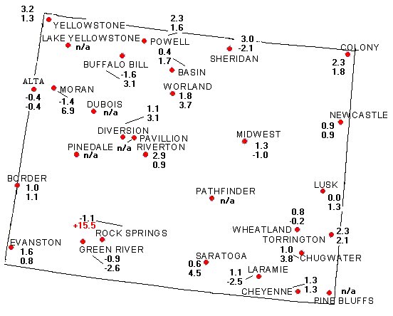
Figure 1.10. The US Historical Climate Network Stations temperature trends. Maximum temperature change (top), minimum temperature change (bottom). Values are in °F per century.
In summary, Figure 1.11 shows that the global climate has changed naturally over time as determined by various proxy methodologies.
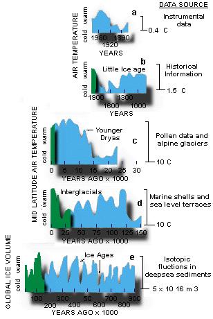
Figure 1.11. Global Climate Change Record (Courtesy of C.R. Scotese11)
2. http://www.techcentralstation.com/climatechange.html
2a. http://www.marshall.org/pdf/materials/136.pdf
3. http://www.scotese.com/climate.htm
4. Ralph Boas, Weatherwise (April 1980), pg. 60-64
4a. http://tao.atmos.washington.edu/greg/lowerrockies/states/WY/station_select.html
4b. http://www.fs.fed.us/institute/ecoregions/eco_download.html
5. Policy Statement on Climate Variability and Change by the American Association of State Climatologists (AASC): http://www.wrds.uwyo.edu/wrds/wsc/aascpolicy.html
6. http://www.cpc.ncep.noaa.gov/charts.shtml
6a. http://www.soest.hawaii.edu/MET/Faculty/businger/poster/GPS/
7. See CD: 01_climate_change folder for more climate division data
8. http://www5.ncdc.noaa.gov/climatenormals/clim85/CLIM85_TEMP01.dat
9. http://www5.ncdc.noaa.gov/climatenormals/clim85/CLIM85_PRCP02.dat
10. http://www.ncdc.noaa.gov/oa/climate/uscrn/index.html
11. http://www.scotese.com/climate.htm
| Table of Contents | | Next Chapter → |
State Climate Office | Water Resources Data System
Last Modified: Fri, 23 May 2025