WRDS/SCO is currently working remotely so there may be a slight delay returning phone calls. Please email wrds@uwyo.edu if you are in need of information and we will respond as soon as possible
Home Data & Products Water Library Wyoming Climate Wyoming Weather Drought CoCoRaHS Education & Outreach Sitemap Cooperative Projects Map
Server
Contact
Share this page

Drought Impacts and Outlook Summaries - 25 Apr 2019

View this Summary as a PDF

Highlights for the State
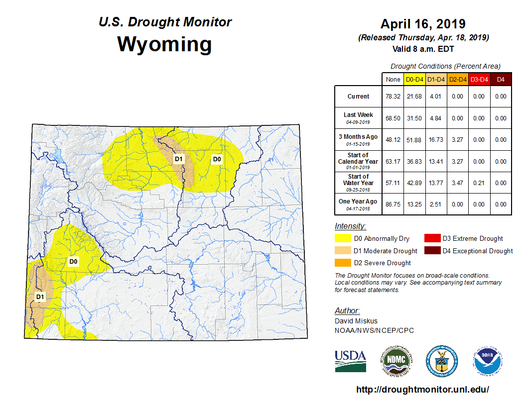
  • Temperatures for March were below normal for all but higher-elevation regions in the Medicine Bow, Absaroka, Teton, Wind River, and Owl Creek Ranges.
  • Precipitation for the month was well above average for most of the southern two-thirds of Wyoming while the northern third was about 75% of normal or less.
  • Abnormally Dry (D0) conditions expanded to the west of the Bighorns during March. Moderate Drought (D1) was removed from south-central Wyoming while the areas of D0 across the south improved considerably leaving the entire southeast quarter drought-free. Much of the improvement was the result of an impressive snow storm that impacted the area 13-14 March.
  • Snowpack at the end of March was greater than 90% of median in all but north-central Wyoming. The Tongue River Basin was the lowest at 80% of median while the Lower North Platte River Basin ranked the highest at 129% of median.
Temperature and Precipitation

  • The statewide average temperature was below normal and the month ranked as the 47th coolest March since 1895. Only Climate Divisions (CD) 1 and 2 in northwestern Wyoming were above the median, ranking as the 56th and 60th warmest, respectively. CD 6 in the northeast ranked the coolest and was the 32nd coolest.
  • Despite the large snow storm in the middle of the month, March ranked in the drier half and was the 54th driest of the last 124 years. CD 1 ranked highest, finishing as the 19th warmest March since 1895. CDs 2, 4, and 5 were ranked not far behind, each having their 23rd driest March. CDs 8 and 10 in the southeast felt the brunt of the storm and experienced their 16th and 22nd wettest Marchs, respectively.
  • The first two-thirds of April has been wetter than normal in the southwest and northeast and below normal in the southeast and Bighorn River Basin. For temperature, April so far has been above average in the northwest and southeast and normal to below normal in the southwest and northeast.

Drought


Drought conditions in the southeastern two-thirds of Wyoming improved drastically since the beginning of March. Thanks, in part, to the storm of 13-14 March, D0 (Abnormally Dry) and D1 (Moderate Drought) conditions were removed from Laramie, Albany, Niobrara, Converse, and Carbon Counties.

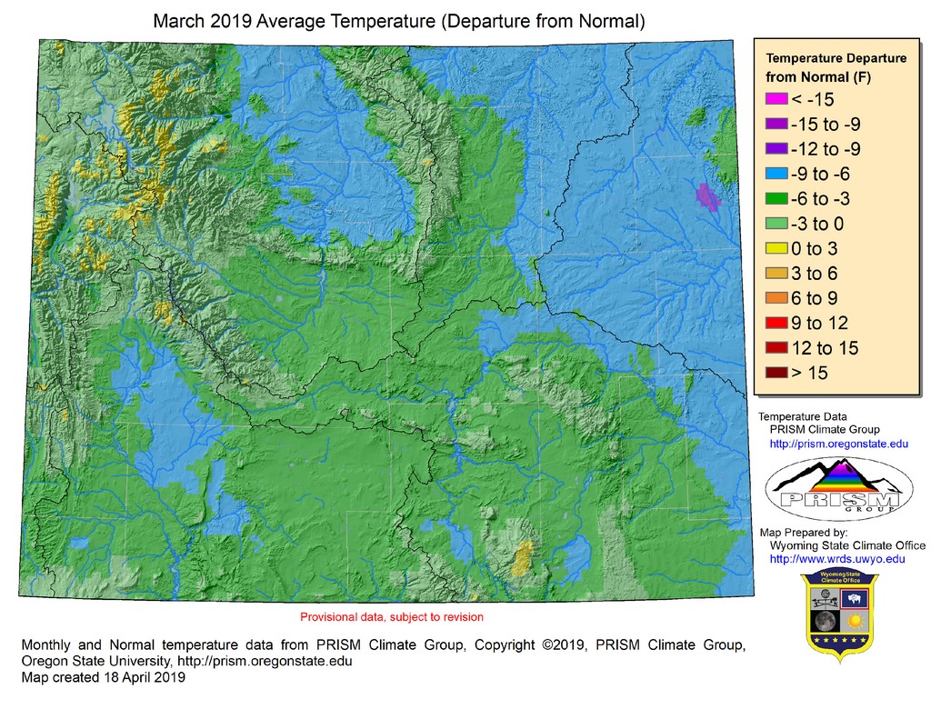
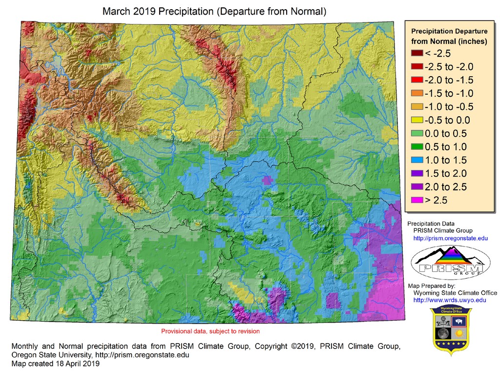
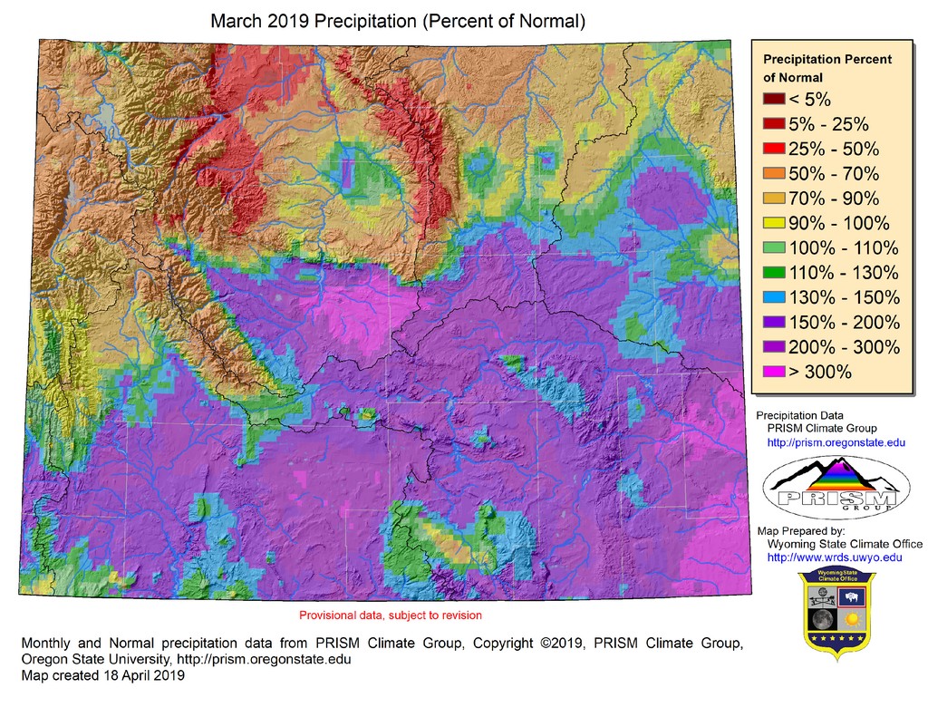
D1 conditions in Uinta County improved slightly but expanded farther northward in Lincoln County. D0 was also removed from most of Fremont and Hot Springs Counties, leaving a drought-free area between the Upper Green and the Bighorn River Basins. All but the extreme southeastern part of the Wind River Reservation was in D0 on 01 March but is now drought-free.

Unfortunately, owing to poor snowpack conditions in north-central Wyoming, D0 expanded further east of the Bighorn Mountains to cover much of Sheridan and Johnson Counties as well as the western part of Campbell County.

Conditions in the Bighorn Mountains have degraded enough that the higher elevations are now in D1 (Moderate Drought). With greater chances for above-average precipitation and with low evaporative demand across affected areas in southern Wyoming, further improvement in the southwest is expected.


Snowpack

Snowpack throughout the state as of 19 April was above average for all but the Bighorn, Powder, Tongue, and Cheyenne River Basins. At this point in the season, percentages do not tell the whole story, but the Cheyenne is the lowest at only 59% of median while the South Platte is at 148% of median.

Compared to conditions at this time last year, snowpack is still less in the north than it was while the southern half is generally at a higher percentage of median.

Additional products can be found at: http://www.wrds.uwyo.edu/sitemap.html

Do you have drought impacts to report? We need your on-the-ground reports and you can input them here: http://droughtreporter.unl.edu/submitreport/
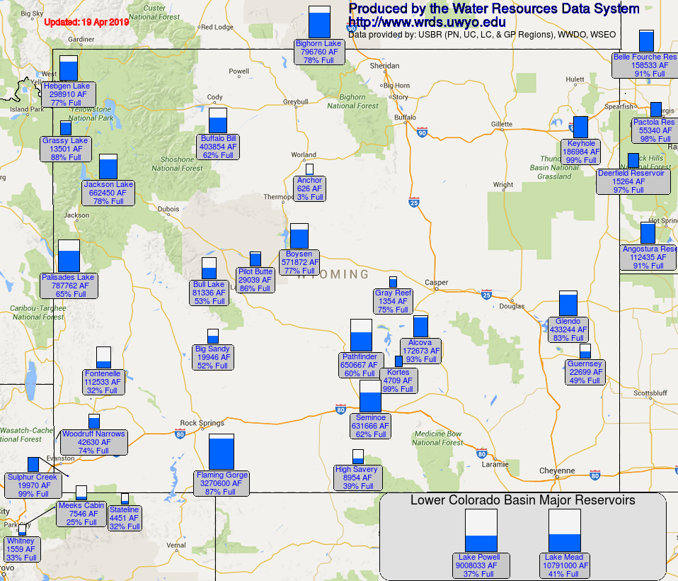
Water Resources
Reservoir levels in Wyoming are lower but most of the major facilities are at or well-above 50% capacity, which is typical for this time of year as they begin to fill from runoff.

Reservoir conditions may be viewed online in larger format at: http://www.wrds.uwyo.edu/surface_water/teacups.html

Downstream, Lake Mead continues to hold at around 41% capacity while Lake Powell has declined another percent since the beginning of March.

The map below shows reservoir conditions in Wyoming as of 19 April.
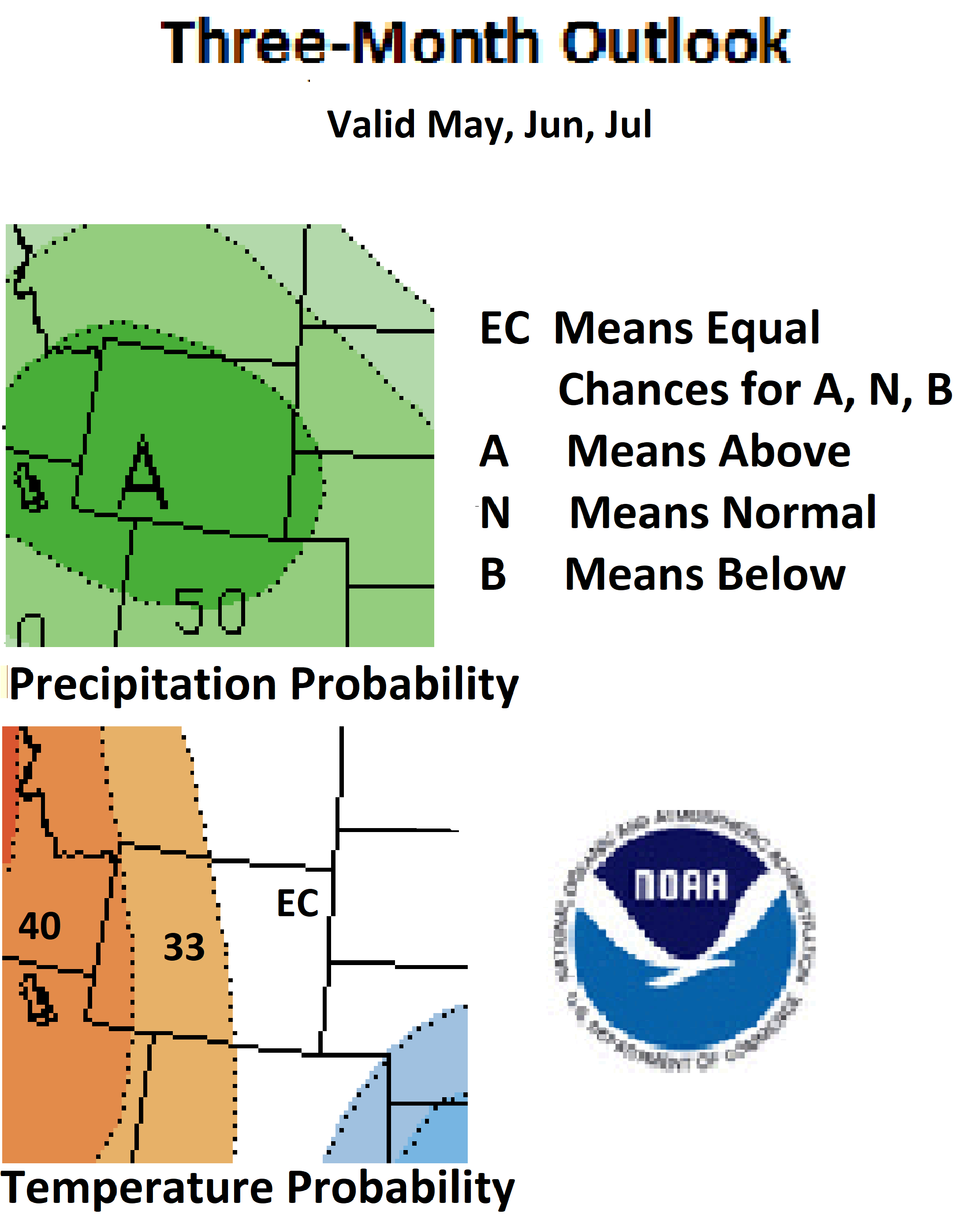
Weather and Climate Outlooks
The latter half of April should see above-average temperatures across the entire state. The odds of this happening increase toward the southeast. For the earlier part of this period, precipitation in the northwest could be above average while the chances are better for below-normal precipitation in the southeast. As we approach the end of the month, we should see better chances of above-normal precipitation statewide.

Moving into May there are slightly better chances for above-normal temperatures in the northwest while the remainder of the state has unclear signals. For precipitation, the better chances for above-normal amounts are in the southern two-thirds of Wyoming while the chances in the northern third, though still favoring above-normal amounts, are not as strong.

Looking at the May thru July timeframe, the best chances for above-normal temperature are in the western quarter of the state with slightly elevated chances existing for the remainder off the western half. The signal is too weak in the eastern half of the state to make a determination for above, below, or average temperature. The signals are much stronger for precipitation with the odds being at better than 50% for above-normal precipitation throughout almost all of Wyoming.

With chances being favorable long term for above-normal precipitation, it is expected that drought conditions, especially in the southwest will continue to improve.

Heard around the State

Natrona Co., Apr 07: "The ground finally thawed, but just below the surface it is very wet. Our reservoir is completely thawed."

Platte Co., Mar 25: "Ground is pretty wet in places due to snow melt, but it is going into the ground, no runoff."

Sheridan Co., Mar 22: "Clear Creek has opened up partially flowing over submerged ice sheets. Most of the ground is bare and starting to thaw. Two yearling White Tail twins just walked by."

Washakie Co., Mar 02: "Piles of plowed and shoveled snow still exist. Sidewalks and areas not previously cleared are icy and treacherous!"

Partners

Stay Tuned and In Touch
The next Wyoming Drought Impacts and Outlook Summary will be released in May. If you need information in the meantime, please reach out to any of the partners listed to the right or contact Tony Bergantino directly at Antonius@uwyo.edu

Live in or around the Wind River Indian Reservation? Check out the Wind River Indian Reservation and Surrounding Area Climate and Drought Summary at: WindRiverRes-Climate-Drought-Summary-Mar2017.html