| |
 | |
| WRDS/SCO is currently working remotely so there may be a slight delay returning phone calls. Please email wrds@uwyo.edu if you are in need of information and we will respond as soon as possible |
|
| ||||||||||||
Drought Impacts and Outlook Summaries - Winter 2018-2019View this Summary as a PDF
Highlights for the State
Drought
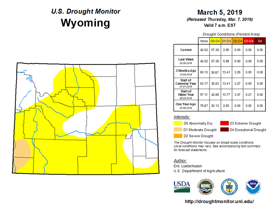
In the southeast, D0 coverage increased to include all of Carbon, most of Converse, and the southeastern half of Natrona Counties. Albany and Laramie Counties also saw large areas covered by the D0 conditions. D1 (Moderate Drought) expanded northward in Sweetwater and Lincoln Counties during the second week in January. In late February, conditions improved such that D1 conditions changed to D0 for all but parts of Lincoln and Uinta Counties. Conditions along the Carbon and Sweetwater County border have improved and the area has been upgraded from D2 (Severe Drought) to D0 (Abnormally Dry) over the course of the winter as a result of above-average precipitation in the Little Snake River Basin.
Snowpack
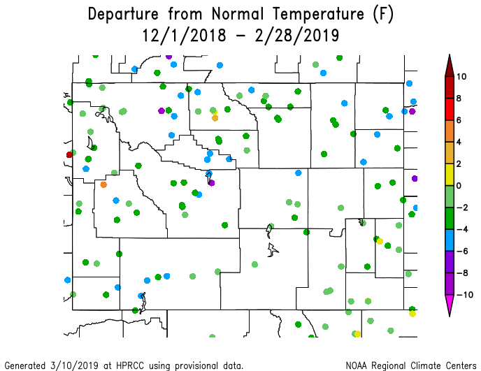
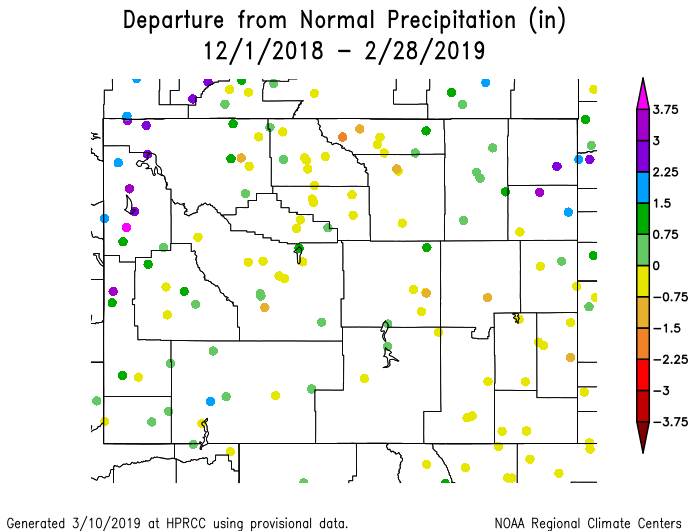
Compared to conditions at this time last year, snowpack is somewhat less in the north but much improved over what southern Wyoming previously experienced. Additional products can be found at: http://www.wrds.uwyo.edu/sitemap.html Do you have drought impacts to report? We need your on-the-ground reports and you can input them here: http://droughtreporter.unl.edu/submitreport/
Water Resources Reservoir conditions may be viewed online in larger format at: http://www.wrds.uwyo.edu/surface_water/teacups.html Downstream, Lake Mead continues to hold at around 40% capacity, however Lake Powell has steadily declined over 5% during the December thru February season (<40% full). The map shows reservoir conditions in Wyoming as of 11 March.
Weather and Climate Outlooks As we move into April and look at longer term conditions, the precipitation signal begins to fade and the outlook becomes more neutral, having even chances for above, below, or normal precipitation. Over the three-month period (Mar thru May), the overall signal for precipitation indicates better chances for above normal precipitation in the southern three-quarters of the state, but that signal is still faint. For temperature, the signal is also quite weak in the Mar thru May timeframe with most of the state having equal chances of above, below, or normal temperatures. The western quarter of Wyoming does have slightly better chances for above-normal temperatures but, as a caution, this is only a slight tilt toward the above-normal side of the scale. For April through June the temperature signal continues, giving only the western third of Wyoming slightly better chances of above-normal temperatures. Precipitation is favored to be above-normal for all but the northwest third of the state. Drought conditions are expected to improve in southwest Wyoming.
Heard around the State Sheridan Co., Feb 28: "Sixty days of snow on the ground, very cold conditions. The frost has grown to several feet deep instead of several inches. At the plumbing department in a hardware store several people were asking about remedies for frozen sewer lines and frozen water lines. Standard depth on these lines is 6ft." Washakie Co., Feb 02: "There is still snow on the ground and piles all around from plowing and shoveling. Gutters are solid ice from melting during the day then regressing overnight." Sweetwater Co., Jan 27: "Snowpack portends to provide good moisture for spring growing conditions."
Partners
Stay Tuned and In Touch Live in or around the Wind River Indian Reservation? Check out the Wind River Indian Reservation and Surrounding Area Climate and Drought Summary at: WindRiverRes-Climate-Drought-Summary-Mar2017.html |
||||||||||||