Drought Impacts and Outlook Summaries - September 2018
View this Summary as a PDF
Highlights for the State
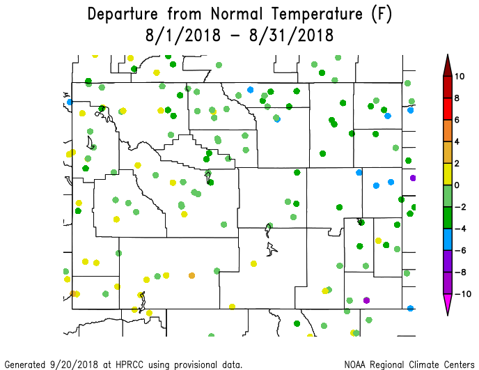
- Temperatures for eastern Wyoming in August were generally from 4°F below to 2°F above normal. Most of the warmer stations were in the southwest and west while those in the rest of the state had cooler averages.
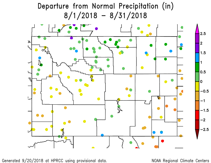
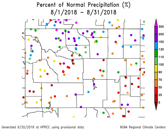
- Precipitation for August varied from 5% to 300% of normal across the state with the northern third being the wettest. In the south, the eastern stations received less compared to normal than the western ones.
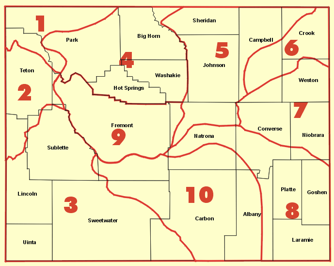
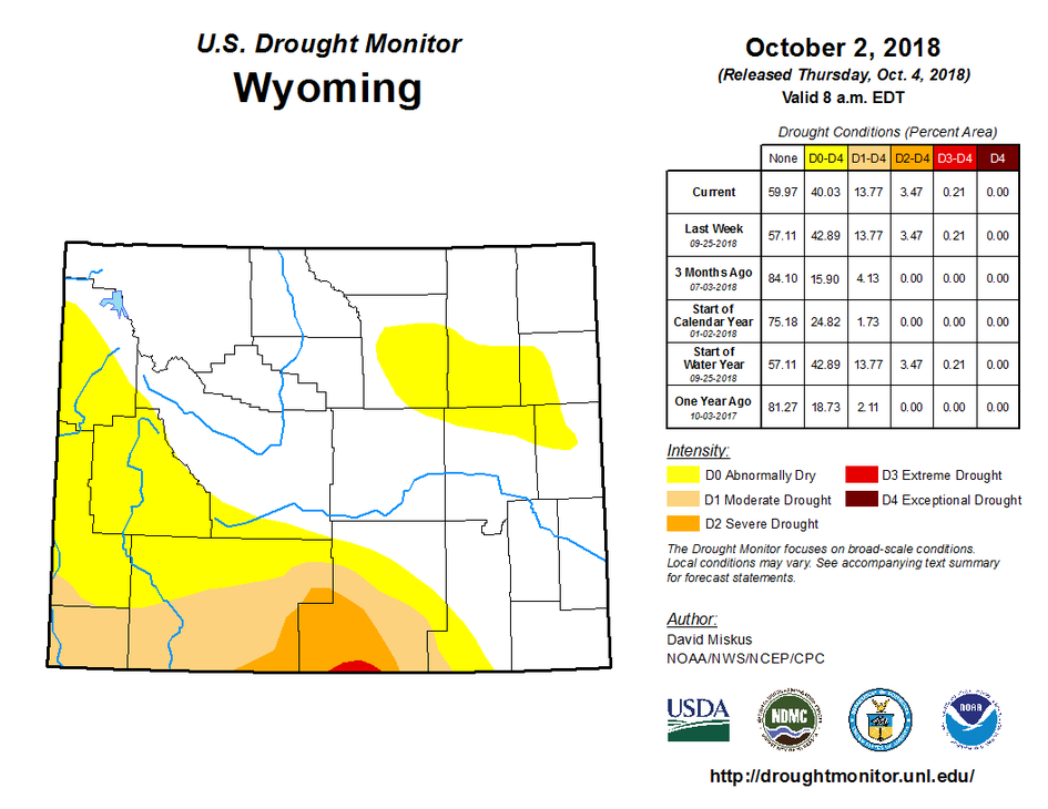
- Drought conditions expanded in the southwest with new areas forming in the northeast. Of note is a small area of D3 (Severe Drought) in the far south of Carbon County. This is the first time since the 6th of September 2016 that any part of Wyoming has been in D3.
- Smoky skies were prevalent in the past several weeks. The Roosevelt Fire in Lincoln and Sublette counties reached over 61,000 acres and control of the fires benefited greatly from recent rains. The Ryan Fire, which straddles the WY/CO border in Carbon County is over 28,000 acres and only 35% contained.
Temperature and Precipitation
- August temperatures were close to normal for most of Wyoming. Climate Division (CD) 3 was the warmest, ranking with the 37th highest average monthly temperature of the last 124 years. CD 7 was the coolest, ranking as the 37th coolest since 1895. The state, as a whole, fell right in the middle with 62 years having a warmer August and 61 being cooler.
- Precipitation in August was more varied. The northern third of the state was mostly above normal while the southern two-thirds was drier than normal. The state, itself, had the 57th wettest (or 68th driest) August since 1895. CD 6 was the wettest, ranking as the 27th driest of the last 124 years. CD 9 was the driest and ranked as the 88th wettest.
- September temperatures have been 2°F below to 2°F above normal for the northern half of the state. Stations in the southern half of Wyoming have been 2°F to 6°F above normal.
- September precipitation was well below normal with the majority of stations receiving less than 25% of normal precipitation.
Drought
D0 (Abnormally Dry) conditions have expanded to cover all of Sublette County in the west. D0 conditions have formed in the northeast, as well, and are covering large parts of Johnson and the southern half of Campbell counties. Southwest Weston, northwest Niobrara, northern parts of Converse and northeastern Natrona counties also are experiencing D0.
D1 (Moderate Drought) has expanded to cover all of Uinta County, extreme southwestern Lincoln County, and about two-thirds of Sweetwater County. In the southeast, D0 in Albany County has grown in the west, spreading east again.
D2 (Severe Drought) extent has remained mostly unchanged however a small area of D3 (Extreme Drought) is beginning to form in the very south-central part of Carbon County near Baggs, stretching to where Battle Creek crosses the WY/CO state line.
Most of Wyoming west of the Divide has received less than 50% of normal precipitation for the last 60 days, evaporative demand has been high, and, while October could bring some relief, drought is expected to persist.
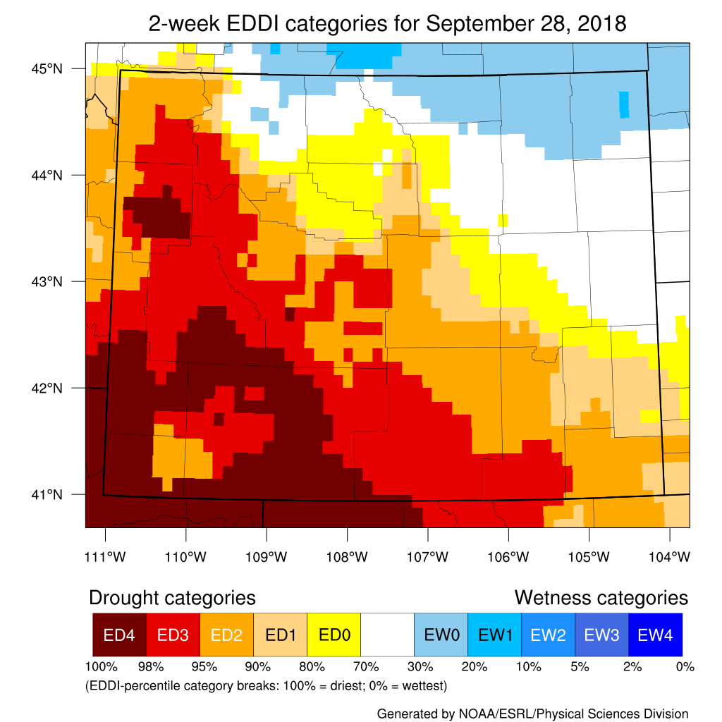
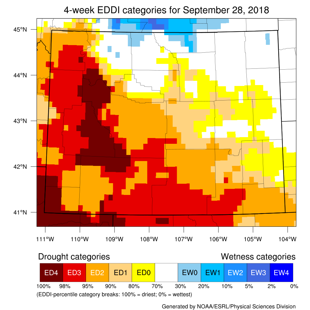
Evaporative Demand Drought Index
The Evaporative Demand Drought Index (EDDI) over the 2-Week period ending 28 September is continuing to show very high-demand conditions most of Wyoming except the northeast and extreme north central parts. These high-demand conditions indicate that the atmosphere is pulling moisture from the soil and vegetation in greater amounts, leading to a drying effect at the surface.
Looking at conditions over the last four weeks, the EDDI is showing the same areas of high-demand, with only some varying levels of intensity.
Additional products can be found at: http://www.wrds.uwyo.edu/sitemap.html
Do you have drought impacts to report? We need your on-the-ground reports and you can input them here: http://droughtreporter.unl.edu/submitreport/
Water Resources
Reservoir levels in Wyoming are lower but several of even the larger ones are still at good capacity.
Reservoir conditions may be viewed online at: http://www.wrds.uwyo.edu/surface_water/teacups.html
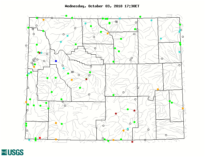
Streamflows in Wyoming are running mostly at normal or above normal; however, there are river gauges in Teton, Fremont, Uinta, and Carbon counties that are much-below normal (<10 percentile).
The map below shows stream conditions in Wyoming as of 03 October.
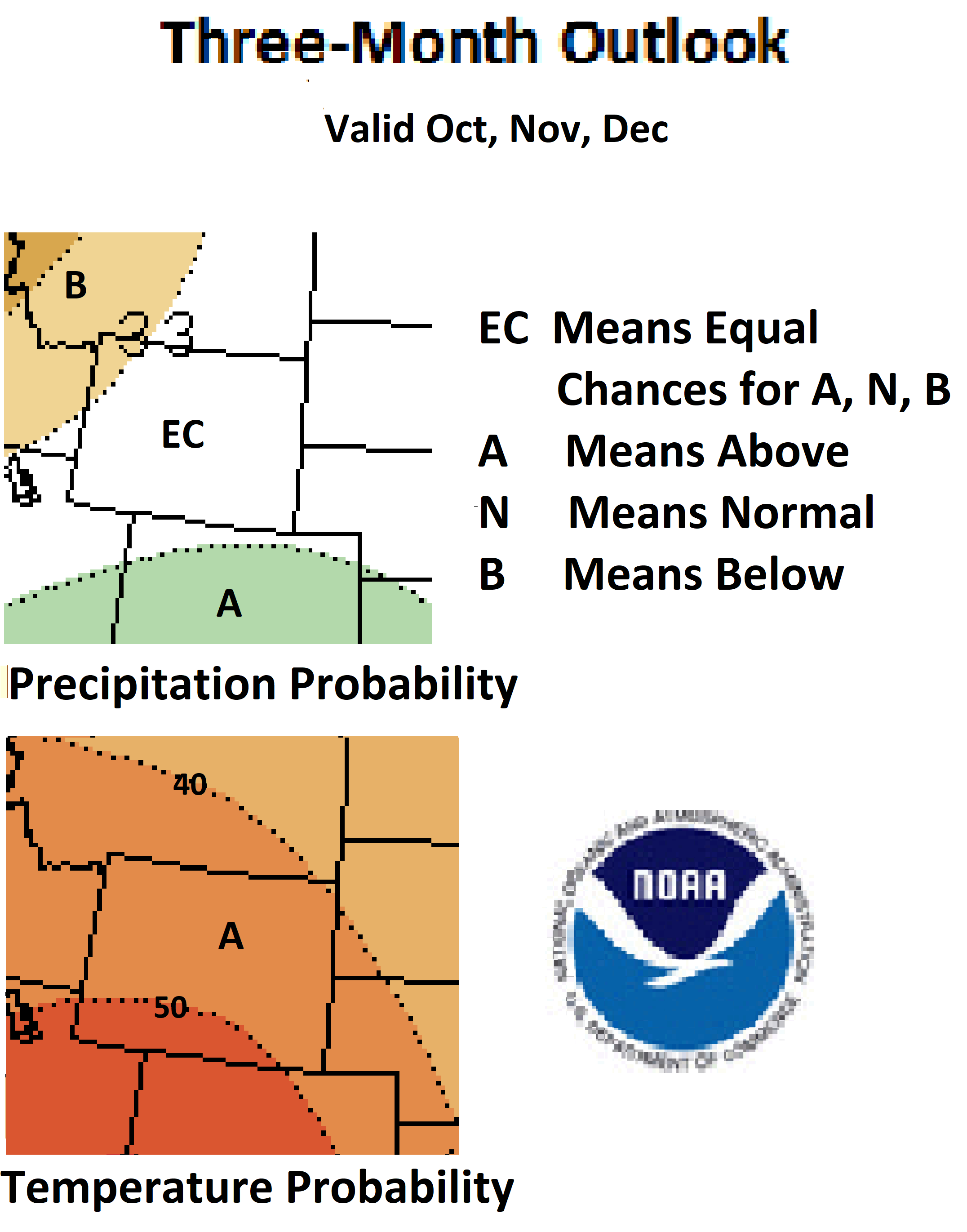
Weather and Climate Outlooks
The outlook for October is showing better chances for below normal temperatures for the northern three-quarters of Wyoming. The odds of cooler than normal conditions increase going northward. The temperature signal for the southern quarter of the state is not clear and there are even chances for above, below, or normal temperatures. The precipitation signal is stronger with the northwest part of Wyoming having a better than 40% chance of above normal precipitation. Most of the rest of the state has a better than 50% chance of being wetter than normal. The first two weeks of October have very good chances for above normal precipitation and below normal temperatures for the entire state.
For the three-month period of October through December there are increased chances for above-normal temperature statewide. The odds are highest for the southwest and decrease somewhat to the northeast. Precipitation amounts during this period of time are not certain except for extreme northwest Wyoming which has a slightly better chance of being drier than normal. This is consistent with developing El Niñonditions in the Pacific. For November through January, the odds are better than 40% in favor of above normal temperatures for the entire state while precipitation is favored to be below normal in the northwest and uncertain for the rest.
High evaporative demand and expected warm weather should see drought conditions continuing for the near term.
Heard around the State
Weston Co., Sep 16: Hot weather has browned the grass and dried up all the small water holes, no fires yet but lots of smoky days from the west.
Carbon Co., Aug 11: Native grasses are back to being brittle and dry. The small amount of rain seems to have lessened the roadside grass fires the fire department has been called out for.
Washakie Co., Sep 09: No new precipitation. Still needing to water or irrigate lawns, gardens, trees, and flowers. Gardens haven't been as productive as in previous years. Fruit trees have more fruit than last year but individual fruits are smaller.
Partners
Stay Tuned and In Touch
The next Wyoming Drought Impacts and Outlook Summary will be released in mid October. If you need information in the meantime, please reach out to any of the partners listed to the right or contact Tony Bergantino directly at Antonius@uwyo.edu
Live in or around the Wind River Indian Reservation? Check out the Wind River Indian Reservation and Surrounding Area Climate and Drought Summary at: WindRiverRes-Climate-Drought-Summary-Mar2017.html
|