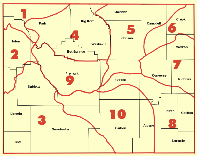
Drought Impacts and Outlook Summaries - August 2018
View this Summary as a PDF
Highlights for the State
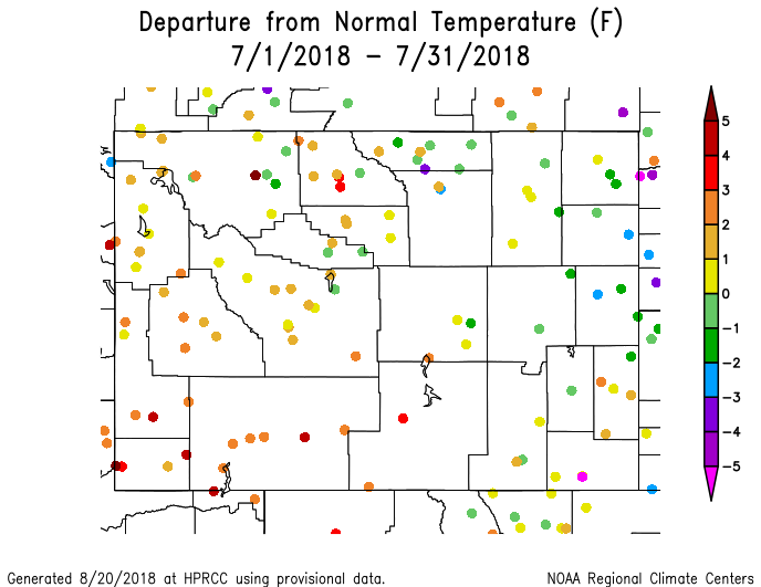
- Temperatures for eastern Wyoming in July were generally within +/-2°F of normal. Warmer temperatures were dominant in the west and even more in the southwest where temperatures were 3°F to 5°F above normal.
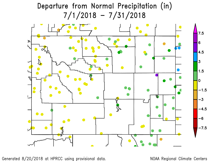
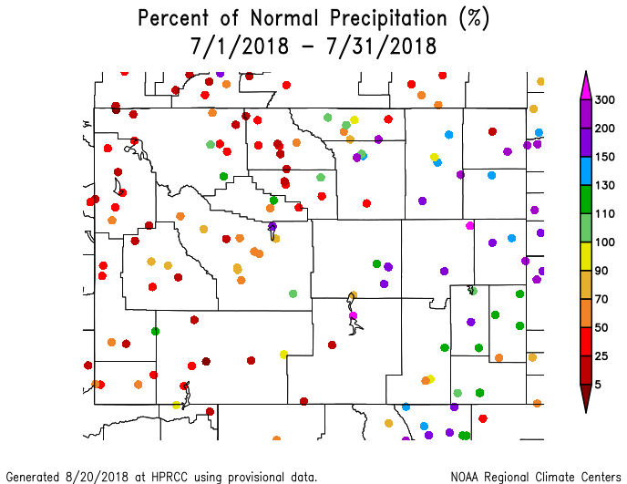
- Precipitation for July was within 1.5. above or below normal across the state with only a few stations exceeding the range on either side. As a percentage, western portions of the state were less than 70% of normal while the eastern parts were up to 300% of normal.
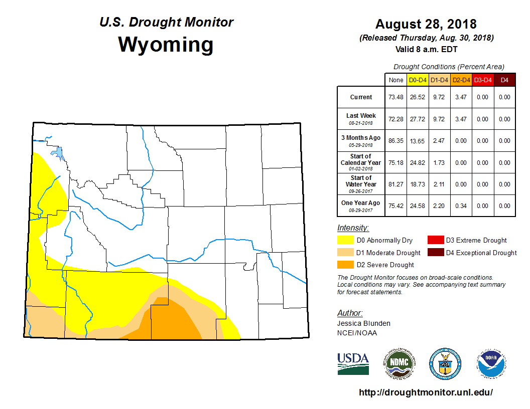
- Drought conditions have expanded in parts of Carbon and Sweetwater counties which are now in D2 (Severe Drought).
- Another fire is active in Wyoming. The Britania Mountain fire west of Wheatland, which was lightning-caused, started on 26 August. As of 31 August, the fire had reached a size of over 26,000 acres with a containment of 64%.
Temperature and Precipitation
- July temperatures were above normal for most of Wyoming although Climate Divisions (CD) 6 and 7 in the northeast were closer to normal. The state, as a whole, ranked as the 26th warmest since 1895 and the individual CDs ranged from the 10th warmest (CD 3) to the 66th warmest (CD 7) for the 124-year period.
- Precipitation in July for Wyoming was highly varied with the western half of the state being drier than normal and the eastern half being wetter than normal. The state, itself, was near normal having the 58th wettest (or 67th driest) July since 1895. CD 1 was the driest, ranking 9th driest of the last 124 years. CD 7 was the wettest and ranked as the 16th wettest.
- August temperatures have been below normal for much of the state with stations in the west and south at or slightly above normal.
- August precipitation has been below normal west of the Divide, and normal to above normal for most areas east of the Divide.
Drought
Since the last update, drought has expanded northward in the far western part of Wyoming. D0 (Abnormally Dry) conditions reached all the way to the Montana border along the western margin of the state but have scaled back to just inside the southern boundary of Yellowstone National Park.
D0 also expanded to cover most of Sweetwater County and spill over slightly into southern Sublette County. In the east, the D0 extent in Albany County has retracted to the west.
D1 (Moderate Drought) has spread to cover more of Carbon County while its westward expansion covers the southern part of Sweetwater as well as most of Uinta and the southwest corner of Lincoln counties. Southwest Carbon and southeast Sweetwater counties are now experiencing D2 (Severe Drought) conditions.
The last week of August was very dry for all but the northwest part of Wyoming and conditions in the south-central and southwest areas are expected to continue or even to deteriorate further.
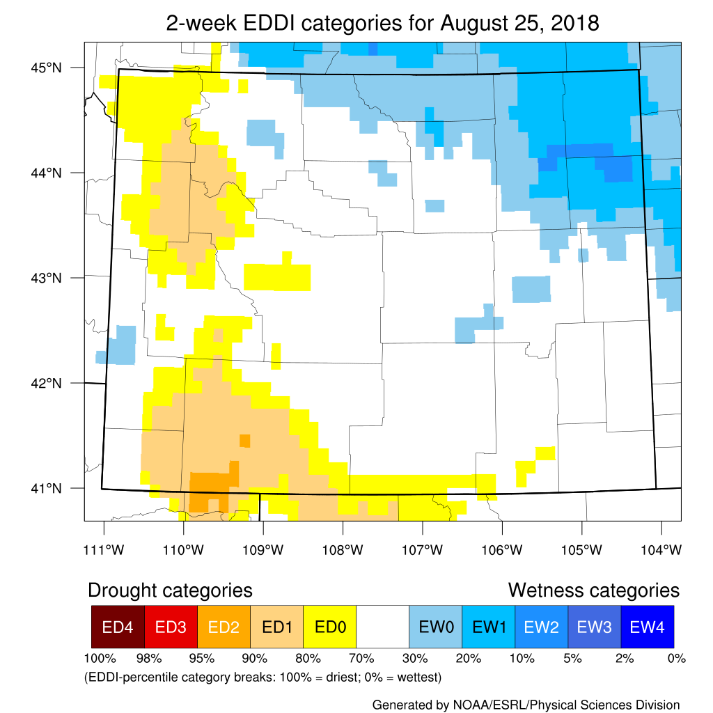
Evaporative Demand Drought Index
The Evaporative Demand Drought Index (EDDI) over the 2-Week period ending 25 August is still showing high-demand conditions across northwest and southeast Wyoming. High-demand conditions indicate that the atmosphere is .thirsty. and is pulling moisture from the soil and vegetation in greater amounts, leading to a drying effect at the surface.
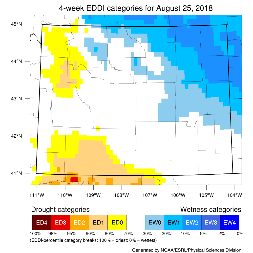
Looking at conditions over the last four weeks, the EDDI is showing the same areas of high-demand, especially in Sweetwater County where the extent of D1 (Moderate Drought) is increasing northward.
Additional products can be found at: http://www.wrds.uwyo.edu/sitemap.html
Do you have drought impacts to report? We need your on-the-ground reports and you can input them here: http://droughtreporter.unl.edu/submitreport/
Water Resources
Reservoirs in Wyoming are a bit lower in the North Platte now but most are still at a good capacity.
Reservoir conditions may be viewed online at: http://www.wrds.uwyo.edu/surface_water/teacups.html
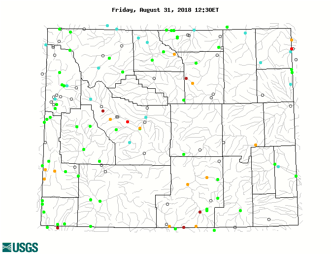
Streamflows in Wyoming are running mostly at normal or above normal; however, there are several river gauges in Lincoln, Fremont, Big Horn, Carbon, and Johnson counties that are well-below normal.
The map below shows stream conditions in Wyoming as of 31 August.
Weather and Climate Outlooks
The outlook for September is showing a slightly better than average chance of warmer conditions for southern Wyoming. The signal is unclear for the rest of the state. For precipitation, it is uncertain which way it will go except for the southeast corner of the state where the odds favor above normal precipitation. For the short term (first two weeks of September) expect above normal temperatures, especially in the southeast, and below normal precipitation, especially for the southwest.
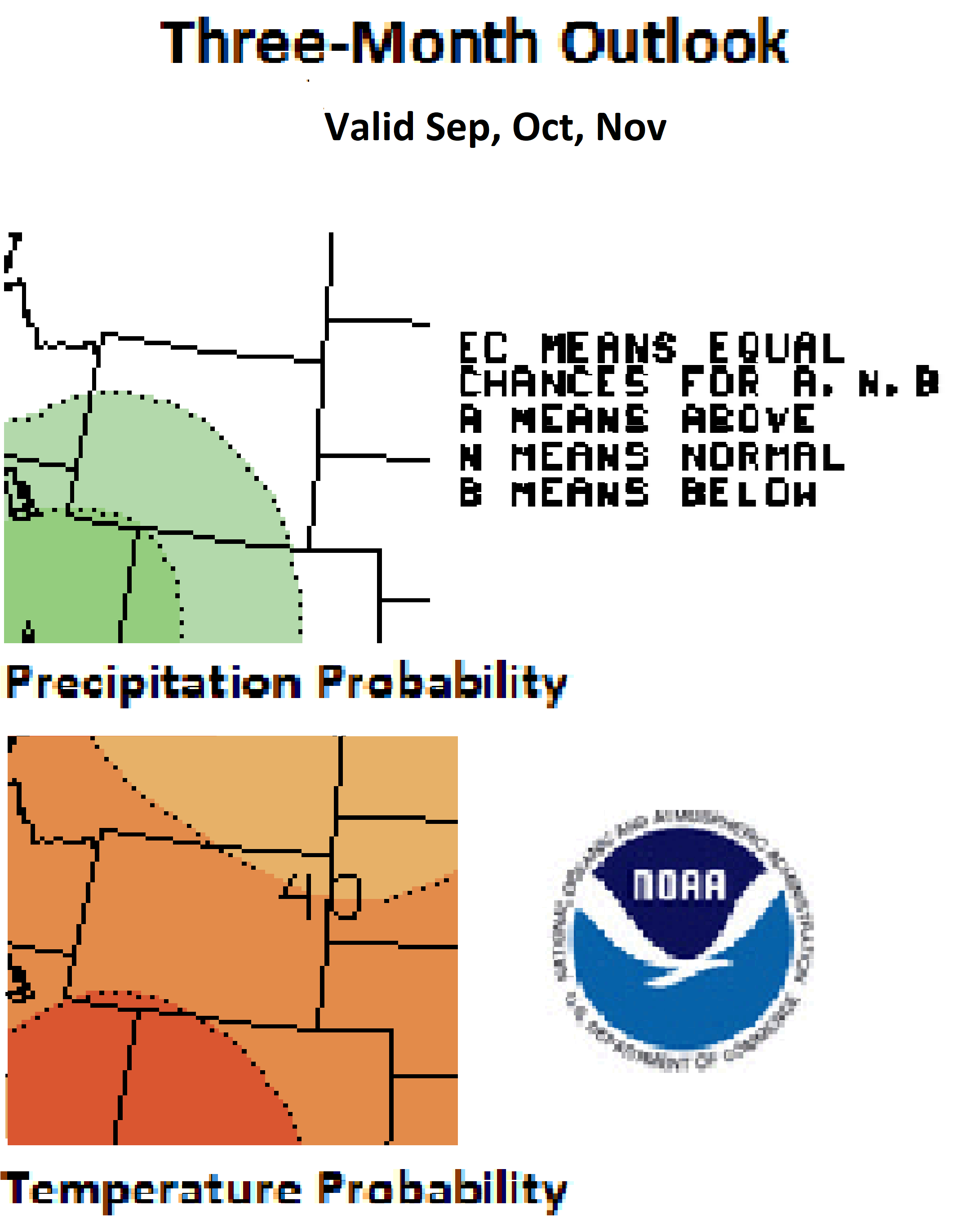
Extending the outlook to the three-month period of September through November there are increased chances for above-normal temperature statewide. The odds are highest for the southwest and decrease somewhat to the northeast. Precipitation amounts during this period of time are expected to be above normal for the southwestern three-quarters of the state. For October through December, the odds are better than 40% in favor of above normal temperatures while precipitation is favored to be below normal in the northwest, above normal in the southeast and uncertain for the two-thirds of the state in between.
Current evaporative demand and expected dry and warm weather should see drought conditions continuing and potentially expanding in southcentral and southwest Wyoming.
Heard around the State
Washakie Co., Jul 28: No significant precipitation for days has left yards, fields, flowers, and everything very dry. Fire danger is high. Thunderstorms without rain are causing fires daily. Temperatures have been lower so we're seeing more folks outside.
Platte Co., Aug 06: Pasture grasses still mostly green. Animals are loving it, sleek and happy. Good grass carry over hopefully for winter.
Weston Co., Jul 29: The same as two weeks ago, lots of insects, especially mosquitoes and deer flies, even up on ridge tops best grass in 40-50 years normal T-showers we are set for a great grass year.
Partners
Stay Tuned and In Touch
The next Wyoming Drought Impacts and Outlook Summary will be released in mid September. If you need information in the meantime, please reach out to any of the partners listed to the right or contact Tony Bergantino directly at Antonius@uwyo.edu
Live in or around the Wind River Indian Reservation? Check out the Wind River Indian Reservation and Surrounding Area Climate and Drought Summary at: WindRiverRes-Climate-Drought-Summary-Mar2017.html
|