| |
 | |
| WRDS/SCO is currently working remotely so there may be a slight delay returning phone calls. Please email wrds@uwyo.edu if you are in need of information and we will respond as soon as possible |
|
| ||||||||||||
Drought Impacts and Outlook Summaries - July 2017View this Summary as a PDF
Highlights for the State
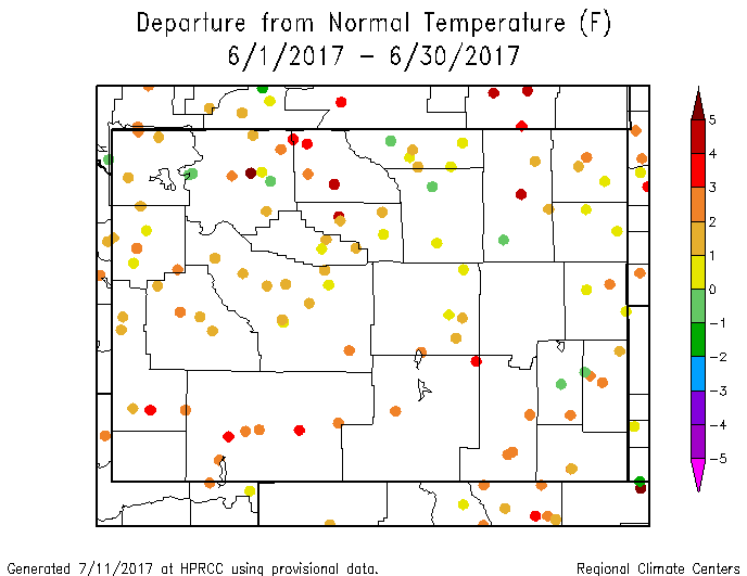
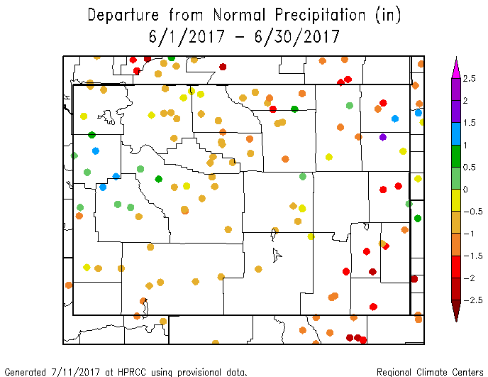
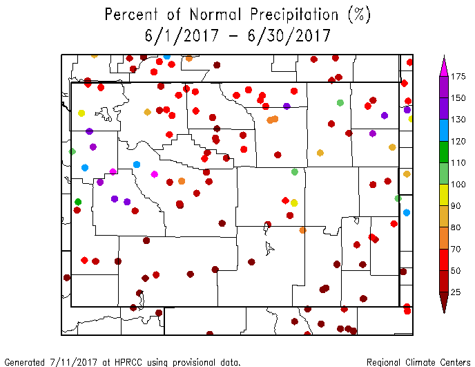
July temperatures to date (20 July) are running above normal across the entire state with only the station at Chugwater in southeast Platte County reporting below-normal temperatures. Generally, July.s temperatures so far have been warmest in the north and west. For statewide precipitation, June was the 34th driest of the last 123 years. Climate Division (CD) 8 was the driest in the state and it ranked as having the 16th driest June since 1894. July so far (20th) has been a dry month for Wyoming although a few stations in the northeast and in Teton County are reporting above-normal precipitation. Fortunately the fire activity has been low considering how dry and warm the conditions have been.
Drought
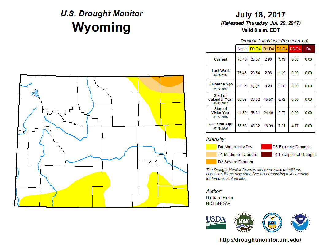
In the southeast, Abnormally Dry (D0) conditions are forming and covering parts of Albany, Goshen, Platte, and Laramie counties. Poor soil moisture content and a lack of precipitation has led to D0 conditions expanding northward into southwest and south-central Wyoming. D0 currently covers parts of Carbon, Sweetwater, and Uinta counties. Although the northeastern part of the state has been receiving some precipitation in the last few weeks, soil moisture is still below normal and drought conditions are expected to continue there.
Evaporative Demand Drought Index
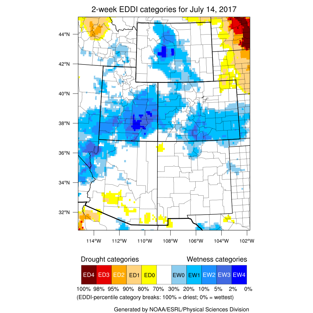
At the 2-Week timeframe, the EDDI is showing normal conditions in the eastern and western parts of the state with central Wyoming tending toward the wet side. The 4-Week Index is showing much the same. Additional products can be found at: http://www.wrds.uwyo.edu/sitemap.html Do you have drought impacts to report? We still need your on-the-ground reports and you can input them here: http://droughtreporter.unl.edu/submitreport/
Water Resources Reservoir conditions may be viewed online at: http://www.wrds.uwyo.edu/surface_water/teacups.html With only a few exceptions in north-central and south-central Wyoming, streamflows are normal to above normal throughout the state. The map below shows stream conditions in Wyoming as of July 20.
Weather and Climate Outlooks Looking at the period of August through October, there are good chances for above-normal temperature statewide. Chances are a bit less in the far eastern parts of the state but still favor temperatures that will be warmer than normal. Precipitation during this period of time is uncertain for most of the state except for slightly elevated chances of above-normal precipitation in the southwest. Moving forward to September through November, there are, again, good chances for above-normal temperature statewide. Precipitation signals are uncertain, making for equal chances of below-normal, normal, or above-normal precipitation. Drought conditions are expected to continue in the northeast part of the Wyoming. Soil moisture conditions are below normal and temperatures have been above normal. The southeast portion of the state has a potential for drought expansion both in extent and intensity with soil moisture and precipitation there being below normal.
Heard around the State Sheridan Co., Jul 10: A wall of smoke blew in from the North at 7:00 pm, ca. 1/4 mile visibility. A neighbor said it may be coming from Ashland, MT. Sheridan Co., Jul 01: No significant precipitation and increased wind. Everything is getting dried out. Crops, lawns, home gardens, trees and flowers are all needing additional irrigation/watering. Fire danger is increasing.
Partners
Stay Tuned and In Touch Live in or around the Wind River Indian Reservation? Check out the Wind River Indian Reservation and Surrounding Area Climate and Drought Summary at: WindRiverRes-Climate-Drought-Summary-Mar2017.html |
||||||||||||