| |
 |
|
| ||||||||||||
Drought Impacts and Outlook Summaries - January-February 2017View this Summary as a PDF
Highlights for the State
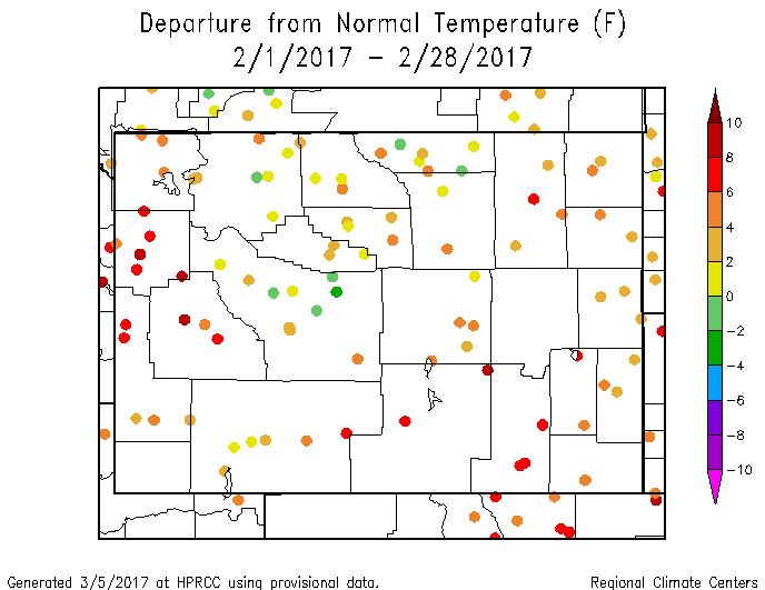
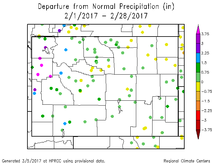
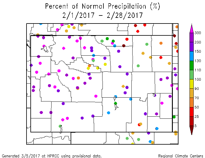
January temperatures were below normal with the statewide temperature ranking as the 40th coolest since 1894. Climate Division (CD) rankings varied between the 24th coolest (CD 9 or the Wind River Basin) and the 55th coolest (CDs 7 and 8, Lower North Platte and Cheyenne/Niobrara river basins). February was warm statewide, ranking as the 16th warmest February in 123 years. CDs 2 (Snake River Basin) and 10 (Laramie and Upper North Platte River Basins) ranked as the 11th warmest. March temperatures, so far, have been normal to well-below normal throughout most of the state with the exception of some northeastern and north-central stations. For statewide precipitation, January was the 19th wettest of the last 123 years. Of particular note are CDs 3 and 10 which finished the month as the 6th wettest on record. These two divisions comprise roughly the counties of Albany, Carbon, Sweetwater, Sublette, Uinta, and the southern half of Lincoln. At the other end of the spectrum was CD 7 (Northern Niobrara, Weston, southern Campbell, and Northern Converse counties) as the 43rd driest. February was wet statewide, ranking as the 5th wettest and 16th warmest. CD 2 (Snake River Basin) ranked as the 2nd wettest February in the last 123 years. CDs 1 (far northwest Wyoming), 9 (Wind River Basin), and 3 (Green and Bear river basins) were similar, ranking as the 3rd, 4th, and 5th wettest respectively since 1894. March's precipitation (through the 8th) has been minimal except for the Snake River Basin and a few scattered sites in the north-central part of Wyoming.
Drought
Severe Drought (D2) has been removed from southeastern Weston and northeastern Niobrara counties. The removal of D2 during the last week of January marks the first time since the week of February 16, 2016 that Wyoming has had no D2 or worse conditions within its borders. Drought conditions in the northeast will likely persist since those areas have been receiving below-normal precipitation.
Snowpack
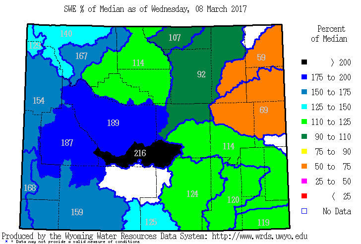
The statewide snowpack has continued to increase significantly in the first months of 2017. Some basins are at or near historical highs. The Powder River Basin (92% of its median), the Belle Fourche (59%) and the Cheyenne (69%) are the only basins in the state below 100% of median snow-water equivalent. At the other extreme are the Sweetwater, Wind, and Upper Green River basins which are all above 185%. This high snowpack has its negatives, too. Snowmelt and ice jams are already causing flooding on the Bighorn and Wind rivers as well as areas around Big Piney and Kemmerer. Snow pack products can be found at: http://www.wrds.uwyo.edu/sitemap.html Do you have drought impacts to report? We still need your on-the-ground reports and you can input them here: http://droughtreporter.unl.edu/submitreport/
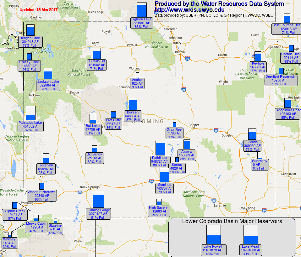
Water Resources The map below shows reservoir conditions in Wyoming as of March 13. This map may be accessed online at: http://www.wrds.uwyo.edu/surface_water/teacups.html
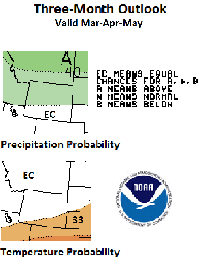
Weather and Climate Outlooks For the next two weeks the chances are greater for above-normal temperatures statewide. The chances of above-normal temperature increase toward the southeast. Precipitation is expected to be above-normal for the northwestern three-quarters of the state for the next week, while the southeast quarter has equal chances of being above-normal, normal, or below-normal. In Week 2 (March 20-26) most of the state is expected to have above-normal precipitation. Looking at the Apr-Jun time frame, the southern half of the state shows slightly greater chances for above-normal temperatures. For precipitation, the northern quarter of the state has a slightly elevated chance of above-normal precipitation. For the May-Jul period, temperature signals show greater chances for above-normal conditions for all but the northeast quarter of the state. For precipitation, there are slightly better chances for above-normal conditions for the northern half of the state while there are equal chances for above-normal, normal, or below-normal precipitation for the southern half. Drought conditions are expected to persist in the northeast part of the state as well as in the very southern part of Albany County.
Heard around the State Weston Co., Jan 25: Feeding hay every day due to snow cover (4-5"). Some drifting in roadways and around buildings/corrals. Teton Co., Jan 26: Snowpack 48" on the flat and roof amounts are 4-8' threatening structures Carbon Co., Jan 28: The wildlife have had little or no feed due to depth of snow. They are congregating on roadways by the hundreds. It's very difficult for them to migrate through the deep snow. Washakie Co., Feb 18: Snowpack in the mountains nearby is above normal which looks good for irrigation this summer. The ice jams on the Big Horn River have broken up and cleanup from the flooding in low lying areas along the river is underway.
Partners
Stay Tuned and In Touch Live in or around the Wind River Indian Reservation? Check out the Wind River Indian Reservation and Surrounding Area Climate and Drought Summary at: http://www.wrds.uwyo.edu/drought/reports/WindRiverRes-Climate-Drought-Summary-Mar2017.html |
||||||||||||