| |
 |
|
| ||||||||||||
Drought Impacts and Outlook Summaries - December 2016View this Summary as a PDF
Highlights for the State
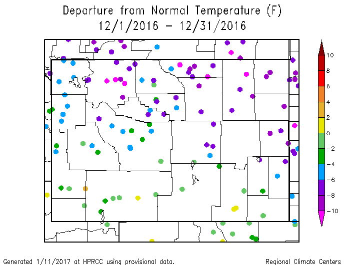
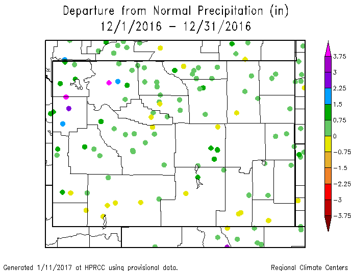
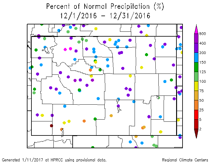
December was a cool month for Wyoming, with locations in the northern two-thirds of the state being 2°F to more than 10° below normal. December 2016 ranked as the 17th coldest December since 1894. The greatest cold anomalies were in Park, Sheridan, and Campbell counties while a few southern stations in Lincoln, Sweetwater, and Albany counties had warm anomalies up to 4° above normal. Statewide, 2016 was the 4th warmest year since 1894. January temperatures, so far, have been well-below normal with stations in the southern half of the state being 4°F to 12°F below normal. The extreme far western part of the state has been about 10°F below normal. Generally, the rest of Wyoming generally has been 12°F to 20°F below normal. The airport at Laramie recorded a -40°F temperature on the morning of the 6th of January. This was a record low for that date and the fifth lowest temperature ever recorded at that location. For statewide precipitation, it was the 6th wettest December since 1894. The southern quarter of Wyoming was a bit drier than the rest of the state. Climate Division 9 (Wind River Basin) had the 2nd-wettest December on record. Statewide, 2016 was the 31st wettest year since 1894. January.s precipitation (through the 11th) has been mixed but generally there are more stations with below-normal precipitation amounts in the far northern parts of Wyoming. The southern part of the state has had above-normal precipitation so far this month thanks to heavy snowfall from January 2-5.
Drought
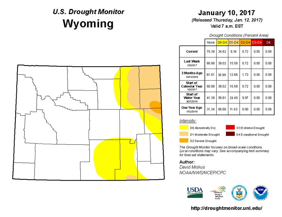
Severe Drought (D2) was removed from Campbell and Crook counties as well as from the northwestern part of Weston County. At the same time, D2 was introduced to the southeastern part of Weston County and to the northeastern part of Niobrara County. In the southeast, D0 was removed from Carbon and Sweetwater counties while D1 was replaced with D0 in parts of Carbon and Albany counties. Drought conditions remain unchanged in the southwestern parts of the state.
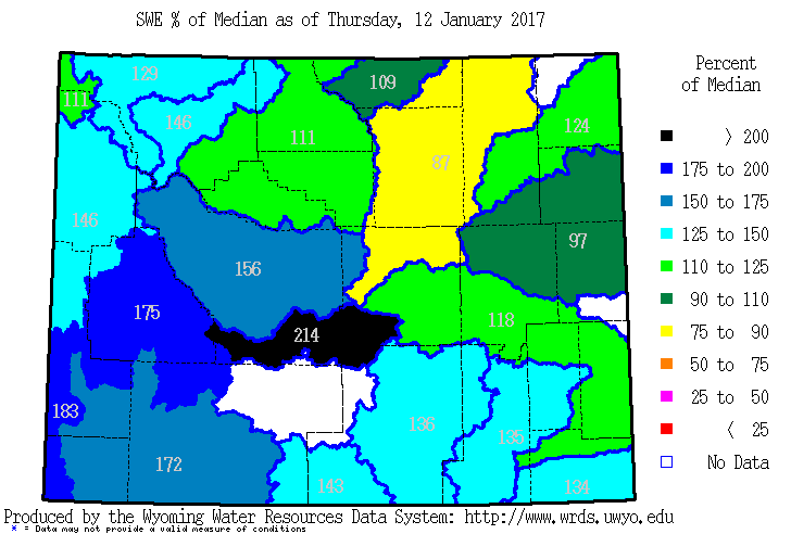
Snowpack
Since the last report, every basin in the state has increased in percent of median snowpack. Only the Powder River Basin (87%) and the Cheyenne River Basin (97%) are less than 100% of their median for this time of year. The southwest quarter of the state is well above the median with all basins there being at least 140% of their median values. Additionally, several basins are near or at their median peak spring snow water equivalent. Snow pack products can be found at: http://www.wrds.uwyo.edu/sitemap.html Do you have drought impacts to report? We still need your on-the-ground reports and you can input them here: http://droughtreporter.unl.edu/submitreport/
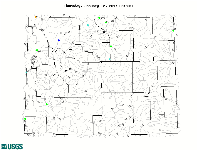
Water Resources The map below shows streamflow for January 12 compared to the historical average for this date. Most stream gauges in Wyoming do not report data during the winter because of icing.
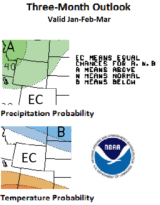
Weather and Climate Outlooks Looking at the Jan-Mar time frame, the signal for temperature is weak and there are equal chances to be at, above, or below the normal. For precipitation, the odds favor above-normal conditions for most of the state. For the Feb-Apr period, temperature signals look much the same except for a slightly greater chance of above-normal temperatures in the southwest. Chances slightly favor above-normal precipitation for the northern half of Wyoming for the same period. The Mar-May period is mostly uncertain still with a slightly better chance of above-normal temperatures for the southern third of Wyoming. There is no clear signal for precipitation. Drought conditions are expected to persist in the northeast and southeast areas of the state into the remainder of January. Conditions are expected to remain with some improvement taking place into the middle of March.
Heard around the State Washakie County, Dec 26: Over 1 foot of snow on the ground and 8 degree temperature so not much melting yet. Roads are snow-packed and icy. All travel is limited! Park County, Dec 18: The extreme cold also kept people indoors. The snow and cold experienced this week closed schools in the area and businesses were generally closed. People did not drive unless they had to.
Partners
Stay Tuned and In Touch Live in or around the Wind River Indian Reservation? Check out the Wind River Indian Reservation and Surrounding Area Climate and Drought Summary at: http://www.hprcc.unl.edu/pdf/Wind-River-Climate-Drought-Summary_Sep16.pdf |
||||||||||||