Streamflow
The following 50 percent chance stream flow yields are for the May through
September period. Smiths Fork near Border is estimated to yield 66,000
acre-feet (61 percent of normal), and Thomas Fork drainage near the Idaho-
Wyoming state line is estimated to yield 16,000 acre-feet or 53 percent of
normal. Bear River near the Utah-Wyoming State Line is expected to yield
about 77,000 acre feet; that is 64 percent of average, while Bear River
near Woodruff is expected to yield about 81,000 acre-feet, about 62 percent
of normal.
==================================================================================================================================
UPPER BEAR RIVER BASIN
Streamflow Forecasts - May 1, 2000
==================================================================================================================================
| <<====== Drier ====== Future Conditions ======= Wetter =====>> |
| |
Forecast Point Forecast | ==================== Chance Of Exceeding * ====================== |
Period | 90% 70% | 50% (Most Probable) | 30% 10% | 30-Yr Avg.
| (1000AF) (1000AF) | (1000AF) (% AVG.) | (1000AF) (1000AF) | (1000AF)
====================================================================|=======================|=====================================
SMITHS FK nr Border, WY MAY-SEP 52 60 | 66 61 | 73 84 109
| |
THOMAS FK nr WY-ID State Line (Disc. MAY-SEP 10.2 13.3 | 16.0 53 | 19.2 25 30
| |
Bear R nr UT-WY State Line APR-SEP 72 78 | 82 65 | 86 93 126
MAY-SEP 67 73 | 77 64 | 81 88 120
| |
BEAR R nr Woodruff, UT APR-SEP 63 82 | 97 63 | 115 149 154
MAY-SEP 51 67 | 81 62 | 98 130 131
| |
==================================================================================================================================
UPPER BEAR RIVER BASIN | UPPER BEAR RIVER BASIN
Reservoir Storage (1000 AF) - End of April | Watershed Snowpack Analysis - May 1, 2000
==================================================================================================================================
Usable | *** Usable Storage *** | Number This Year as % of
Reservoir Capacity| This Last | Watershed of =================
| Year Year Avg | Data Sites Last Yr Average
========================================================================|=========================================================
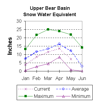
WOODRUFF NARROWS 57.3 57.3 57.3 --- | UPPER BEAR RIVER in Utah 7 47 59
|
| SMITHS & THOMAS FORKS 4 51 62
|
| BEAR RIVER abv ID line 9 46 56
|
| NORTHWEST 68 51 64
|
| NORTHEST 15 79 76
|
| SOUTHEAST 37 72 75
|
| SOUTHWEST 34 53 62
|
 To May 2000 Basin Outlook Report Contents Page