Wind River Basin
May 1997

Snow
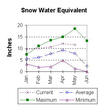
The Wind River basin has well above average snow water equivalent (SWE) for this time of the year. The Wind River basin above Boysen Reservoir averages about 50 percent above normal (SWE) for May 1. Above Dubois, the water content is about 66% above normal for this time of the year, while the Popo Agie drainage is about 36% and the Little Wind is about 41% above normal. All drainages are well above last year at this time. See the Basin Summary Of Snow Course Data at the front of this report for details.

Precipitation
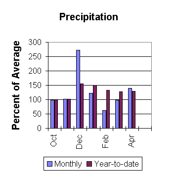
April precipitation in the basin, varied from 35 percent of average at Hobbs Park to 209 percent of average for St. Lawrence Ranger Station. April's average precipitation for the basin was above normal (39 percent above average for the 13 reporting stations); that is about 62 percent more than last years amount. Water year-to-date precipitation is 29 percent more than normal. The current water-year-to-date average is about 15 percent more than last year at this time.

Reservoirs
Current storage varies from 76 to 101 percent of average. Current storage, compared to average for the three storage reservoirs in the basin, is as follows; Bull Lake 101% (80,300 acre feet), Boysen 76% (381,300 acre feet), and Pilot Butte 79% (23,800 acre feet). Bull Lake is about 17 percent below last year's storage amount, while Boysen is 16 percent less and Pilot Butte is 4 percent more than last year at this time.

Streamflow
There should be an adequate water supply this year. If the present trend continues, some excessive flows can be expected this spring. In the upper portion of the drainage, Wind River near Dubois is expected to yield about 134,000 acre feet (about 34 percent above normal) during the May to September period. Other forecast points on the Wind River drainage include Wind River above Bull Lake 695,000 acre feet (36% above normal), Wind River at Riverton 875,000 acre feet (44% above average), and below Boysen 1,120,000 acre feet (48 % above normal). Bull Lake Creek near Lenore is expected to yield about 230,000 acre feet (29% above normal), Little Popo Agie River near Lander about 69,000 acre feet (41% above normal), South Fork of Little Wind near Fort Washakie about 105,000 acre feet (35% above normal), and Little Wind River near Riverton about 435,000 acre feet (44 percent more than normal). All forecasts are for the May to September period.

==================================================================================================================================
                                                         WIND RIVER BASIN
                                               Streamflow Forecasts - May 1, 1997
==================================================================================================================================
                                              |  <<====== Drier ======  Future Conditions  =======  Wetter =====>>  |             
                                              |                                                                     |
  Forecast Point                     Forecast |  ==================== Chance Of Exceeding * ======================  |
                                      Period  |    90%       70%    |  50% (Most Probable)  |      30%       10%    |  30-Yr Avg.
                                              | (1000AF)  (1000AF)  |   (1000AF)  (% AVG.)  |    (1000AF)  (1000AF) |    (1000AF)
====================================================================|=======================|=====================================
WIND RIVER near Dubois               MAY-SEP       118       128    |      134       141    |       141       150             95
                                                                    |                       |
WIND RIVER abv Bull Lake Cr (2)      MAY-SEP       615       663    |      695       136    |       727       775            511
                                                                    |                       |
WIND RIVER at Riverton (2)           MAY-SEP       747       823    |      875       144    |       927      1003            609
                                                                    |                       |
WIND RIVER below Boysen (2)          MAY-SEP       861      1015    |     1120       148    |      1225      1379            758
                                                                    |                       |
BULL LAKE CREEK near Lenore (2)      MAY-SEP       199       218    |      230       129    |       242       261            179
                                                                    |                       |
LITTLE POPO AGIE RIVER near Lander   MAY-SEP        56        64    |       69       141    |        74        82             49
                                                                    |                       |
SF LITTLE WIND RIVER nr Fort Washaki MAY-SEP        90        99    |      105       135    |       111       120             78
                                                                    |                       |
LITTLE WIND RIVER near Riverton      MAY-SEP       336       395    |      435       144    |       475       534            303
                                                                    |                       |
==================================================================================================================================
                            WIND RIVER BASIN                            |                    WIND RIVER BASIN
             Reservoir Storage (1000 AF) - End of April                 |        Watershed Snowpack Analysis - May 1, 1997
==================================================================================================================================
                                      Usable |  *** Usable Storage ***  |                            Number     This Year as % of
Reservoir                            Capacity|  This      Last          |   Watershed                  of       =================
                                             |  Year      Year     Avg  |                          Data Sites   Last Yr   Average
========================================================================|=========================================================
BULL LAKE                              151.8     80.3     96.8     79.9 |   WIND RIVER above Dubios     7       110       166
                                                                        |
BOYSEN                                 596.0    381.3    453.2    502.6 |   LITTLE WIND                 2       125       141
                                                                        |
PILOT BUTTE                             31.6     23.8     24.9     30.1 |   POPO AGIE                   7       131       136
                                                                        |
                                                                        |   WIND above Boysen Resv     15       121       148
                                                                        |
==================================================================================================================================
 * 90%, 70%, 30%, and 10% chances of exceeding are the probabilities that the actual volume will exceed the volumes in the table.

The average is computed for the 1961-1990 base period.

(1) - The values listed under the 10% and 90% Chance of Exceeding are actually 5% and 95% exceedance levels.                  
(2) - The value is natural volume - actual volume may be affected by upstream water management.


To May 1997 Basin Outlook Report Contents Page