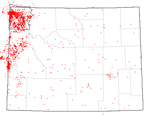
Historic Wyoming Earthquakes (Magnitude >= 2.5 or Intensity >= III) from 1871 to present
Epicenters shown in red
Historic Wyoming Earthquakes (Magnitude >= 2.5 or Intensity >= III) from 1871 to present
Epicenters shown in red
The map above represents earthquakes of magnitiude 2.5 or intensity III and above that have occured in Wyoming from 1871 to present. As can be seen, historic earthquakes have occurred in every county in Wyoming. Damaging earthquakes can occur anywhere in the state. Magnitude 7.5 events can occur in western Wyoming, magnitude 6.75 events can occur along the northern and southern margins of the Wind River Basin. And magnitude 6.25 to 6.5 events can occur anywhere in the rest of the state.
These web pages have been generated for two reasons. The first of these is to increase awareness of earthquakes in Wyoming. The second is to provide citizens with a means to access current earthquake data for the state.
The map above shows many historic earthquakes. The Wyoming State Geological Survey (WSGS) and the Water Resources Data System (WRDS) are in the process of generating a searchable database for Wyoming. At the present time, only limited historic data can be retrieved. Presently the database contains records from: