| Display Map Abbreviations Landslides in red | ||
| Name: | Landslide Coverage - Munger_Mountain 7.5 Minute Quadrangle | 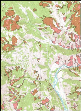 |
| Scale: | 1:24,000 | |
| Projection: | UTM Zone 12 | |
| Datum: | NAD 1983 | |
| Data Type: | Polygon | |
| Date: | 2004 | |
| Source: | Wyoming State Geological Survey | |
| Download | Zipped shapefile (119 kb) L43110c7.zip | |
| Full Metadata | USGS basemap DRG-E from Beartooth Mapping, Inc, Red Lodge, MT | |