Lower North Platte River Basin (9)
January 2002

Snow
SWE for the North Platte River basin in Wyoming averages 64 percent of normal (71 % of last year). The Sweetwater drainage SWE is currently 87 percent (101 percent of last year). Deer and LaPrele Creek SWE is 52 percent of average (47 percent of last year. SWE for the North Platte above the Laramie River drainage is 66 percent of average (73 % of last year). SWE for the Laramie River above the mouth is 57 percent of average (65 % of last year). SWE for the Laramie River above Laramie is 60 percent of average (69 % of last year). SWE for the Little Laramie River is 50 percent of average (57 percent of last year). For more information see Basin Summary of Snow Courses at beginning of report.

Precipitation
Of the 14 reporting stations, percentages for the month range from 0 to 113. December precipitation for the basin was 49 percent of average (42 percent of last year). The water year-to-date precipitation for the basin is currently 82 percent of average (96 percent of last year). Year to date percentages range from 61 to 167.

Reservoir
The Lower North Platte River basin reservoir storage is well below to well above average. Reservoir storage is as follows: Alcova 156,200 acre feet (101 percent of average); Glendo 192,800 acre feet (68 percent of average); Guernsey 11,000 acre feet (153 percent of average); Pathfinder 487,100 acre feet (77 percent of average); Seminoe 480,400 acre feet (76 percent of average). Wheatland No.2 19,000 acre feet (45 percent of average). Water allocated to project use is near average with North Platte Project users at 46 percent of average, Kendrick Project users at 101 percent of average, and Glendo Project users at 116 percent of average.

Streamflow
Yields from 37 to 66 percent are expected in the basin during the forecast period. The following yields are based on the fifty percent chance probability runoff for the April through September forecast period. The Sweetwater near Alcova is forecast to yield about 38,000 acre-feet (48 percent of average). Deer Creek at Glenrock is expected to yield about 37 percent of average (15,000 acre-feet). LaPrele Creek above the reservoir is estimated to yield 40 percent of average (9,500 acre-feet). North Platte River below Guernsey Reservoir is expected to yield about 49 percent of normal (490,000 acre-feet), and below Glendo Reservoir is anticipated to yield about 49 percent of average (480,000 acre-feet). Laramie River near Woods should yield about 66 percent of average (89,000 acre-feet). The Little Laramie near Filmore should produce about 42,000 acre-feet (66 percent of average).

==================================================================================================================================
                                      LOWER NORTH PLATTE, SWEETWATER & LARAMIE RIVER BASINS
                                               Streamflow Forecasts - January 1, 2002
==================================================================================================================================
                                              |  <<====== Drier ======  Future Conditions  =======  Wetter =====>>  |             
                                              |                                                                     |
  Forecast Point                     Forecast |  ==================== Chance Of Exceeding * ======================  |
                                      Period  |    90%       70%    |  50% (Most Probable)  |      30%       10%    |  30-Yr Avg.
                                              | (1000AF)  (1000AF)  |   (1000AF)  (% AVG.)  |    (1000AF)  (1000AF) |    (1000AF)
====================================================================|=======================|=====================================
Sweetwater River nr Alcova           APR-JUL      15.9        27    |       35        47    |        52        76             74
                                     APR-SEP      17.8        30    |       38        48    |        55        80             80
                                                                    |                       |
Deer Creek at Glenrock               APR-SEP       2.7       8.9    |     15.0        37    |        23        37             41
                                                                    |                       |
La Prele Creek ab La Prele Reservoir APR-SEP       0.8       4.3    |      9.5        40    |      17.7        37             24
                                                                    |                       |
Alcova to Orin Gain                  APR-JUL        20        42    |       56        37    |        95       152            152
                                     APR-SEP        23        45    |       59        37    |        98       156            161
                                                                    |                       |
North Platte River blw Glendo Reserv APR-JUL       212       368    |      475        50    |       582       738            960
                                     APR-SEP       344       425    |      480        49    |       592       758            990
                                                                    |                       |
North Platte River blw Guernsey Resv APR-JUL       321       419    |      485        50    |       618       813            970
                                     APR-SEP       323       422    |      490        49    |       628       830           1010
                                                                    |                       |
Laramie River nr Woods               APR-SEP        43        70    |       89        66    |       117       159            135
                                                                    |                       |
Little Laramie River nr Filmore      APR-SEP        26        36    |       42        66    |        52        66             64
                                                                    |                       |
==================================================================================================================================
          LOWER NORTH PLATTE, SWEETWATER & LARAMIE RIVER BASINS         |  LOWER NORTH PLATTE, SWEETWATER & LARAMIE RIVER BASINS
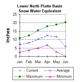
             Reservoir Storage (1000 AF) - End of December              |        Watershed Snowpack Analysis - January 1, 2002
==================================================================================================================================
                                      Usable |  *** Usable Storage ***  |                            Number     This Year as % of
Reservoir                            Capacity|  This      Last          |   Watershed                  of       =================
                                             |  Year      Year     Avg  |                          Data Sites   Last Yr   Average
========================================================================|=========================================================
ALCOVA                                 184.3    156.2    156.4    154.4 |   SWEETWATER                  2       101        87
                                                                        |
GLENDO                                 506.4    192.8    236.8    282.9 |   DEER & LaPRELE CREEKS       2        47        52
                                                                        |
GUERNSEY                                45.6     11.0     10.1      7.2 |   N PLATTE abv Laramie R.    17        73        66
                                                                        |
PATHFINDER                            1016.5    487.1    700.5    635.7 |   LARAMIE RIVER abv Laramie   3        69        60
                                                                        |
SEMINOE                               1016.7    480.4    717.9    631.1 |   LITTLE LARAMIE RIVER        1        57        50
                                                                        |
WHEATLAND #2                            98.9     19.0      ---     42.2 |   LARAMIE RIVER above mouth   4        65        57
                                                                        |
NORTH PLATTE PROJ                     1062.1    260.7    526.8    568.4 |   NORTH PLATTE               17        71        64
                                                                        |
KENDRICK PROJECT                      1201.7    830.1    972.0    819.8 |
                                                                        |
GLENDO PROJECT USERS                   183.2    135.0    136.5    116.2 |
                                                                        |
==================================================================================================================================
 * 90%, 70%, 30%, and 10% chances of exceeding are the probabilities that the actual volume will exceed the volumes in the table.

(1) - The values listed under the 10% and 90% Chance of Exceeding are actually 5% and 95% exceedance levels.                  
(2) - The value is natural volume - actual volume may be affected by upstream water management.


To January 2002 Basin Outlook Report Contents Page