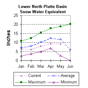
Lower North Platte River Basin (9)
May 2001

Snow
SWE for the North Platte River basin in Wyoming averages 78 percent of normal (103 % of last year). The Sweetwater drainage SWE is currently 51 percent (69 percent of last year). Deer and LaPrele Creek SWE is 94 percent of average (108 percent of last year. SWE for the North Platte above the Laramie River drainage is 77 percent of average (98 % of last year). SWE for the Laramie River above Laramie is 80 percent of average (97 % of last year). SWE for the Little Laramie River is 79 percent of average (163 percent of last year). SWE for the Laramie River above the mouth is 80 percent of average (112 % of last year). For more information see Basin Summary of Snow Courses at beginning of report.

Precipitation
Last months precipitation ranged from 24 to 214 percent for the 11 reporting stations. April precipitation for the basin was 125 percent of average (113 percent of last year). The water year-to-date precipitation for the basin is currently 82 percent of average (92 percent of last year). Year to date percentages range from 46 to 134.

Reservoir
The Lower North Platte River basin usable storage is average to well above average. Reservoir storage is as follows: Alcova 178,300 acre feet (99 percent of average); Glendo 466,600 acre feet (102 percent of average); Guernsey 26,600 acre feet (81 percent of average); Pathfinder 774,400 acre feet (127 percent of average); Seminoe 663,500 acre feet (169 percent of average). Wheatland No.2 53,000 acre feet (97 percent of average).. Water allocated to project use is near average with North Platte Project users at 100 percent of average, Kendrick Project users at 119 percent of average, and Glendo Project users at 134 percent of average.

Streamflow
Yields from 16 to 87 percent are expected in the basin during the forecast period. The following yields are based on the fifty percent chance probability runoff for the May through September forecast period. The Sweetwater near Alcova is forecast to yield about 9,700 acre-feet (16 percent of average). Deer Creek at Glenrock is expected to yield about 42 percent of average (12,600 acre-feet). LaPrele Creek above the reservoir is estimated to yield 58 percent of average (11,500 acre-feet). North Platte River below Guernsey Reservoir is expected to yield about 51 percent of normal (405,000 acre-feet), and below Glendo Reservoir is anticipated to yield about 52 percent of average (430,000 acre-feet). Laramie River near Woods should yield about 87 percent of average (111,000 acre-feet). The Little Laramie near Filmore should produce about 48,000 acre-feet (79 percent of average).

==================================================================================================================================
                                      LOWER NORTH PLATTE, SWEETWATER & LARAMIE RIVER BASINS
                                               Streamflow Forecasts - May 1, 2001
==================================================================================================================================
                                              |  <<====== Drier ======  Future Conditions  =======  Wetter =====>>  |             
                                              |                                                                     |
  Forecast Point                     Forecast |  ==================== Chance Of Exceeding * ======================  |
                                      Period  |    90%       70%    |  50% (Most Probable)  |      30%       10%    |  30-Yr Avg.
                                              | (1000AF)  (1000AF)  |   (1000AF)  (% AVG.)  |    (1000AF)  (1000AF) |    (1000AF)
====================================================================|=======================|=====================================
Sweetwater River nr Alcova           MAY-JUL       5.6       6.7    |      7.4        13    |      16.7        30             56
                                     MAY-SEP       7.0       8.6    |      9.7        16    |      19.7        34             61
                                                                    |                       |
Deer Creek at Glenrock               MAY-SEP       7.5      10.4    |     12.6        42    |      15.0      18.9             30
                                                                    |                       |
La Prele Creek ab La Prele Reservoir MAY-SEP       3.2       7.3    |     11.5        58    |      17.0        28             20
                                                                    |                       |
North Platte River blw Glendo Reserv MAY-JUL       146       291    |      390        51    |       489       634            761
                                     MAY-SEP       277       353    |      405        51    |       506       656            793
                                                                    |                       |
North Platte River blw Guernsey Resv MAY-JUL       251       343    |      405        52    |       525       700            780
                                     MAY-SEP       270       365    |      430        52    |       554       737            825
                                                                    |                       |
Laramie River nr Woods               MAY-SEP        66        93    |      111        87    |       129       156            127
                                                                    |                       |
Little Laramie River nr Filmore      MAY-SEP        39        44    |       48        79    |        52        58             61
                                                                    |                       |
==================================================================================================================================
          LOWER NORTH PLATTE, SWEETWATER & LARAMIE RIVER BASINS         |  LOWER NORTH PLATTE, SWEETWATER & LARAMIE RIVER BASINS
             Reservoir Storage (1000 AF) - End of April                 |        Watershed Snowpack Analysis - May 1, 2001
==================================================================================================================================
                                      Usable |  *** Usable Storage ***  |                            Number     This Year as % of
Reservoir                            Capacity|  This      Last          |   Watershed                  of       =================
                                             |  Year      Year     Avg  |                          Data Sites   Last Yr   Average
========================================================================|=========================================================
ALCOVA                                 184.3    178.3    197.7    179.9 |   SWEETWATER                  3        73        51
                                                                        |
GLENDO                                 506.4    466.6    516.1    457.6 |   DEER & LaPRELE CREEKS       2        96        88
                                                                        |
GUERNSEY                                45.6     26.6     36.0     32.8 |   N PLATTE abv Laramie R.    24        97        76
                                                                        |
PATHFINDER                            1016.5    774.4    994.6    609.0 |   LARAMIE RIVER abv Laramie   9        97        80
                                                                        |
SEMINOE                               1016.7    663.5    753.0    392.0 |   LITTLE LARAMIE RIVER        4       163        79
                                                                        |
WHEATLAND #2                            98.9     53.0     77.0     54.9 |   LARAMIE RIVER above mouth  12       112        80
                                                                        |
NORTH PLATTE PROJ                               NO REPORT               |   NORTH PLATTE               32       103        77
                                                                        |
KENDRICK PROJECT                                NO REPORT               |
                                                                        |
GLENDO PROJECT USERS                            NO REPORT               |
                                                                        |
==================================================================================================================================
 * 90%, 70%, 30%, and 10% chances of exceeding are the probabilities that the actual volume will exceed the volumes in the table.

The average is computed for the 1961-1990 base period.

(1) - The values listed under the 10% and 90% Chance of Exceeding are actually 5% and 95% exceedance levels.                  
(2) - The value is natural volume - actual volume may be affected by upstream water management.


To May 2001 Basin Outlook Report Contents Page