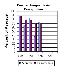
Precipitation
February precipitation was 74 percent of average for the 11 reporting
stations (62 percent of last year). Monthly percentages range from
37 to 110 percent of average. Precipitation for the year ranges from
62 to 94 percent of average at the reporting stations. Year-to-date
precipitation is about 71 percent of average in the basin; this is 75
percent of last year at this time.
Reservoir
Tongue River Reservoir is currently at 111 percent of average storage
for this time of year (33,400 acre feet) - the reservoir is about 44
percent of capacity (total capacity is 68,000 acre feet). Last year
at this time the reservoir was storing about 36,600 acre feet -
average storage is about 30,100 acre feet for this time of the year.
Detailed reservoir data is shown on the following page and on the
reservoir storage summary at the beginning of this report.
Streamflow
The following runoff values are for the 50 percent probability during
the April through September forecast period. The estimated yield for
Tongue River near Dayton is 73,000-acre feet (64 percent of normal).
Middle Fork of the Powder River near Barnum is estimated to yield
9,200-acre feet (47 percent of average). The North Fork of the
Powder near Hazelton should yield about 5,800 acre-feet (57 percent
of normal). The estimated yield for Clear Creek near Buffalo is
22,000 acre-feet (56 percent of average). Rock Creek near Buffalo
will yield about 12,200 acre-feet (51 percent of normal), and Piney
Creek at Kearny should yield about 23,700 acre-feet (47 percent of
average).
==================================================================================================================================
                                                   POWDER & TONGUE RIVER BASINS
                                               Streamflow Forecasts - March 1, 2001
==================================================================================================================================
                                              |  <<====== Drier ======  Future Conditions  =======  Wetter =====>>  |
                                              |                                                                     |
  Forecast Point                     Forecast |  ==================== Chance Of Exceeding * ======================  |
                                      Period  |    90%       70%    |  50% (Most Probable)  |      30%       10%    |  30-Yr Avg.
                                              | (1000AF)  (1000AF)  |   (1000AF)  (% AVG.)  |    (1000AF)  (1000AF) |    (1000AF)
====================================================================|=======================|=====================================
TONGUE RIVER nr Dayton (2)           APR-SEP        54        66    |       73        64    |        85       102            115
                                                                    |                       |
MIDDLE FORK POWDER nr Barnum         APR-SEP       5.9       7.9    |      9.2        47    |      12.1      16.4           19.7
                                                                    |                       |
NORTH FORK POWDER nr Hazelton        APR-SEP       4.3       5.2    |      5.8        57    |       6.8       8.4           10.1
                                                                    |                       |
CLEAR CREEK nr Buffalo               APR-SEP      15.2      19.5    |       22        56    |        27        34             39
                                                                    |                       |
ROCK CREEK nr Buffalo                APR-SEP       9.4      11.0    |     12.2        51    |      14.5      17.8             24
                                                                    |                       |
PINEY CREEK at Kearny                APR-SEP      11.2      18.9    |       24        47    |        35        51             51
                                                                    |                       |
==================================================================================================================================
                      POWDER & TONGUE RIVER BASINS                      |              POWDER & TONGUE RIVER BASINS
             Reservoir Storage (1000 AF) - End of February              |        Watershed Snowpack Analysis - March 1, 2001
==================================================================================================================================
                                      Usable |  *** Usable Storage ***  |                            Number     This Year as % of
Reservoir                            Capacity|  This      Last          |   Watershed                  of       =================
                                             |  Year      Year     Avg  |                          Data Sites   Last Yr   Average
========================================================================|=========================================================
TONGUE RIVER                            68.0     33.4     36.6     30.1 |   UPPER TONGUE RIVER          8        66        60
                                                                        |
                                                                        |   GOOSE CREEK                 2        73        62
                                                                        |
                                                                        |   CLEAR CREEK                 4        57        52
                                                                        |
                                                                        |   CRAZY WOMAN CREEK           3        54        43
                                                                        |
                                                                        |   UPPER POWDER RIVER          4        69        56
                                                                        |
                                                                        |   POWDER RIVER in WY          8        63        54
                                                                        |
==================================================================================================================================
 * 90%, 70%, 30%, and 10% chances of exceeding are the probabilities that the actual volume will exceed the volumes in the table.

The average is computed for the 1961-1990 base period.

(1) - The values listed under the 10% and 90% Chance of Exceeding are actually 5% and 95% exceedance levels.
(2) - The value is natural volume - actual volume may be affected by upstream water management.
 To March 2001 Basin Outlook Report Contents Page