Precipitation
Of the 11 reporting stations, percentages for the month range from 37 to
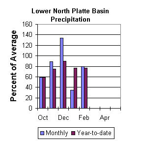
190. February precipitation for the basin was 80 percent of average (64
percent of last year). The water year-to-date precipitation for the basin
is currently 77 percent of average (92 percent of last year). Year to date
percentages range from 46 to 137.
Reservoir
The Lower North Platte River basin reservoir storage is average to well
above average. Reservoir storage is as follows: Alcova 156,800 acre feet
(100 percent of average); Glendo 326,000 acre feet (85 percent of average);
Guernsey 15,300 acre feet (112 percent of average); Pathfinder 753,300 acre
feet (128 percent of average); Seminoe 650,500 acre feet (159 percent of
average). Wheatland No.2 34,000 acre feet (79 percent of average)..
Water allocated to project use is near average with North Platte Project
users at 99 percent of average, Kendrick Project users at 119 percent of
average, and Glendo Project users at 107 percent of average.
==================================================================================================================================
                                      LOWER NORTH PLATTE, SWEETWATER & LARAMIE RIVER BASINS
                                               Streamflow Forecasts - March 1, 2001
==================================================================================================================================
                                              |  <<====== Drier ======  Future Conditions  =======  Wetter =====>>  |
                                              |                                                                     |
  Forecast Point                     Forecast |  ==================== Chance Of Exceeding * ======================  |
                                      Period  |    90%       70%    |  50% (Most Probable)  |      30%       10%    |  30-Yr Avg.
                                              | (1000AF)  (1000AF)  |   (1000AF)  (% AVG.)  |    (1000AF)  (1000AF) |    (1000AF)
====================================================================|=======================|=====================================
Sweetwater River nr Alcova           APR-JUL      15.9        30    |       41        59    |        58        84             69
                                     APR-SEP      17.0        32    |       45        61    |        63        89             74
                                                                    |                       |
Deer Creek at Glenrock               APR-SEP        21        31    |       40       103    |        50        66             39
                                                                    |                       |
La Prele Creek ab La Prele Reservoir APR-SEP       5.6      14.4    |       24        96    |        37        64             25
                                                                    |                       |
Laramie River nr Woods               APR-SEP        50        78    |       97        72    |       124       163            135
                                                                    |                       |
Little Laramie River nr Filmore      APR-SEP        25        38    |       46        72    |        54        67             64
                                                                    |                       |
==================================================================================================================================
          LOWER NORTH PLATTE, SWEETWATER & LARAMIE RIVER BASINS         |  LOWER NORTH PLATTE, SWEETWATER & LARAMIE RIVER BASINS
             Reservoir Storage (1000 AF) - End of February              |        Watershed Snowpack Analysis - March 1, 2001
==================================================================================================================================
                                      Usable |  *** Usable Storage ***  |                            Number     This Year as % of
Reservoir                            Capacity|  This      Last          |   Watershed                  of       =================
                                             |  Year      Year     Avg  |                          Data Sites   Last Yr   Average
========================================================================|=========================================================
ALCOVA                                 184.3    156.8    156.1    157.1 |   SWEETWATER                  3        75        55
                                                                        |
GLENDO                                 506.4    326.0    381.8    383.1 |   DEER & LaPRELE CREEKS       4       104        97
                                                                        |
GUERNSEY                                45.6     15.3     15.9     13.6 |   N PLATTE abv Laramie R.    26        89        79
                                                                        |
PATHFINDER                            1016.5    753.3    960.5    590.0 |   LARAMIE RIVER abv Laramie   8        82        77
                                                                        |
SEMINOE                               1016.7    650.5    798.2    409.0 |   LITTLE LARAMIE RIVER        4        89        74
                                                                        |
WHEATLAND #2                            98.9     34.0     70.0     43.2 |   LARAMIE RIVER above mouth  11        85        77
                                                                        |
NORTH PLATTE PROJ                     1062.1    625.4    998.6    633.3 |   NORTH PLATTE               33        89        79
                                                                        |
KENDRICK PROJECT                      1201.7    970.4    989.9    818.1 |
                                                                        |
GLENDO PROJECT USERS                   183.2    136.0    154.7    126.8 |
                                                                        |
==================================================================================================================================
 * 90%, 70%, 30%, and 10% chances of exceeding are the probabilities that the actual volume will exceed the volumes in the table.

The average is computed for the 1961-1990 base period.

(1) - The values listed under the 10% and 90% Chance of Exceeding are actually 5% and 95% exceedance levels.
(2) - The value is natural volume - actual volume may be affected by upstream water management.
 To March 2001 Basin Outlook Report Contents Page