Lower North Platte River Basin (9)
February 2001

Snow
SWE for the North Platte River basin in Wyoming averages 76 percent of normal (95 % of last year). The Sweetwater drainage SWE is currently 53 percent (75 percent of last year). Deer and LaPrele Creek SWE is 107 percent of average (126 percent of last year. SWE for the North Platte above the Laramie River drainage is 77 percent of average (96 % of last year). SWE for the Laramie River above the mouth is 73 percent of average (91 % of last year). SWE for the Laramie River above Laramie is 73 percent of average (91 % of last year). SWE for the Little Laramie River is 66 percent of average (84 percent of last year). For more information see Basin Summary of Snow Courses at beginning of report.

Precipitation
Of the 11 reporting stations, percentages for the month range from 4 to 273. January precipitation for the basin was 35 percent of average (30 percent of last year). The water year-to-date precipitation for the basin is currently 77 percent of average (107 percent of last year). Year to date percentages range from 40 to 149.

Reservoir
The Lower North Platte River basin reservoir storage is average to well above average. Reservoir storage is as follows: Alcova 156,600 acre feet (100 percent of average); Glendo 283,500 acre feet (86 percent of average); Guernsey 12,800 acre feet (188 percent of average); Pathfinder 728,100 acre feet (132 percent of average); Seminoe 680,900 acre feet (146 percent of average). Wheatland No.2 34,000 acre feet (85 percent of average).. Water allocated to project use is near average with North Platte Project users at 97 percent of average, Kendrick Project users at 119 percent of average, and Glendo Project users at 114 percent of average.

Streamflow
Yields from 62 to 77 percent are expected in the basin during the forecast period. The following yields are based on the fifty percent chance probability runoff for the April through September forecast period. The Sweetwater near Alcova is forecast to yield about 46,000 acre-feet (62 percent of average). Deer Creek at Glenrock is expected to yield about 77 percent of average (30,000 acre-feet). LaPrele Creek above the reservoir is estimated to yield 72 percent of average (18,000 acre-feet). North Platte River below Guernsey Reservoir is expected to yield about 62 percent of normal (615,000 acre-feet), and below Glendo Reservoir is anticipated to yield about 63 percent of average (605,000 acre-feet). Laramie River near Woods should yield about 76 percent of average (102,000 acre-feet). The Little Laramie near Filmore should produce about 44,000 acre-feet (69 percent of average).

  
==================================================================================================================================
                                      LOWER NORTH PLATTE, SWEETWATER & LARAMIE RIVER BASINS
                                               Streamflow Forecasts - February 1, 2001
==================================================================================================================================
                                              |  <<====== Drier ======  Future Conditions  =======  Wetter =====>>  |             
                                              |                                                                     |
  Forecast Point                     Forecast |  ==================== Chance Of Exceeding * ======================  |
                                      Period  |    90%       70%    |  50% (Most Probable)  |      30%       10%    |  30-Yr Avg.
                                              | (1000AF)  (1000AF)  |   (1000AF)  (% AVG.)  |    (1000AF)  (1000AF) |    (1000AF)
====================================================================|=======================|=====================================
Sweetwater River nr Alcova           APR-JUL      16.6        23    |       41        59    |        59        87             69
                                     APR-SEP      18.5        27    |       46        62    |        65        93             74
                                                                    |                       |
Deer Creek at Glenrock               APR-SEP      11.3        21    |       30        77    |        40        58             39
                                                                    |                       |
La Prele Creek ab La Prele Reservoir APR-SEP       7.3      10.2    |     18.0        72    |        29        52             25
                                                                    |                       |
North Platte River blw Glendo Reserv APR-JUL       322       478    |      585        63    |       692       848            925
                                     APR-SEP       327       493    |      605        63    |       717       883            958
                                                                    |                       |
North Platte River blw Guernsey Resv APR-JUL       262       457    |      590        63    |       723       918            938
                                     APR-SEP       275       477    |      615        62    |       753       955            985
                                                                    |                       |
Laramie River nr Woods               APR-SEP        36        75    |      102        76    |       129       168            135
                                                                    |                       |
Little Laramie River nr Filmore      APR-SEP        23        36    |       44        69    |        52        65             64
                                                                    |                       |
==================================================================================================================================
          LOWER NORTH PLATTE, SWEETWATER & LARAMIE RIVER BASINS         |  LOWER NORTH PLATTE, SWEETWATER & LARAMIE RIVER BASINS
             Reservoir Storage (1000 AF) - End of January               |        Watershed Snowpack Analysis - February 1, 2001
==================================================================================================================================
                                      Usable |  *** Usable Storage ***  |                            Number     This Year as % of
Reservoir                            Capacity|  This      Last          |   Watershed                  of       =================
                                             |  Year      Year     Avg  |                          Data Sites   Last Yr   Average
========================================================================|=========================================================
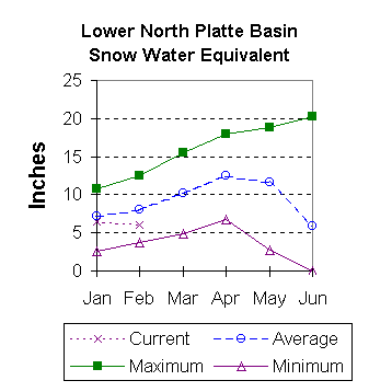
ALCOVA                                 184.3    156.6    156.0    156.1 |   SWEETWATER                  3        80        53
                                                                        |
GLENDO                                 506.4    283.5    327.2    330.8 |   DEER & LaPRELE CREEKS       4       126       107
                                                                        |
GUERNSEY                                45.6     12.8     13.2      6.8 |   N PLATTE abv Laramie R.    26        96        77
                                                                        |
PATHFINDER                            1016.5    728.1    935.9    553.0 |   LARAMIE RIVER abv Laramie   8        91        73
                                                                        |
SEMINOE                               1016.7    680.9    830.1    467.0 |   LITTLE LARAMIE RIVER        4        84        66
                                                                        |
WHEATLAND #2                            98.9     34.0     66.0     40.1 |   LARAMIE RIVER above mouth  11        89        72
                                                                        |
NORTH PLATTE PROJ                     1062.1    584.9    945.9    601.0 |   NORTH PLATTE               33        95        76
                                                                        |
KENDRICK PROJECT                      1201.7    971.2    991.4    819.1 |
                                                                        |
GLENDO PROJECT USERS                   183.2    136.3    155.2    119.8 |
                                                                        |
==================================================================================================================================
 * 90%, 70%, 30%, and 10% chances of exceeding are the probabilities that the actual volume will exceed the volumes in the table.

The average is computed for the 1961-1990 base period.

(1) - The values listed under the 10% and 90% Chance of Exceeding are actually 5% and 95% exceedance levels.                  
(2) - The value is natural volume - actual volume may be affected by upstream water management.


To February 2001 Basin Outlook Report Contents Page