Streamflow
Expected yields vary from 48 to 67 percent of average across the basin. The following forecast values are based on a 50 percent chance probability for the April through July forecast period. Green
River near Green River is forecast to yield about 530,000-acre feet (59 percent of average). East Fork of Smiths Fork near Robertson is estimated to yield 19,400 acre-feet (65 percent of average).
The estimated yield for Hams Fork near Frontier is 35,000-acre feet (53 percent of average). Viva Naughton Reservoir inflow will be about 43,000-acre feet (48 percent of average).
==================================================================================================================================
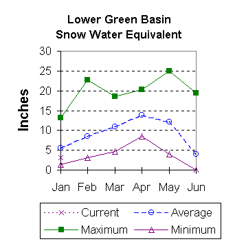
LOWER GREEN RIVER BASIN
Streamflow Forecasts - January 1, 2000
==================================================================================================================================
| <<====== Drier ====== Future Conditions ======= Wetter =====>> |
| |
Forecast Point Forecast | ==================== Chance Of Exceeding * ====================== |
Period | 90% 70% | 50% (Most Probable) | 30% 10% | 30-Yr Avg.
| (1000AF) (1000AF) | (1000AF) (% AVG.) | (1000AF) (1000AF) | (1000AF)
====================================================================|=======================|=====================================
Green River nr Green River, WY APR-JUL 243 405 | 530 59 | 655 1007 899
| |
Blacks Fork nr Robertson APR-JUL 33 51 | 64 67 | 77 95 95
| |
EF of Smiths Fork nr Robertson APR-JUL 14.4 17.2 | 19.4 65 | 22 26 30
| |
Hams Fk blw Pole Ck nr Frontier APR-JUL 18.0 27 | 35 53 | 44 58 66
| |
Hams Fk Inflow to Viva Naughton Res APR-JUL 16.9 26 | 43 48 | 60 86 89
| |
Flaming Gorge Reservoir Inflow APR-JUL 251 553 | 725 61 | 897 1423 1196
| |
==================================================================================================================================
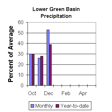
LOWER GREEN RIVER BASIN | LOWER GREEN RIVER BASIN
Reservoir Storage (1000 AF) - End of December | Watershed Snowpack Analysis - January 1, 2000
==================================================================================================================================
Usable | *** Usable Storage *** | Number This Year as % of
Reservoir Capacity| This Last | Watershed of =================
| Year Year Avg | Data Sites Last Yr Average
========================================================================|=========================================================
FONTENELLE 344.8 210.4 226.9 208.3 | HAMS FORK RIVER 3 58 51
|
FLAMING GORGE 3749.0 3269.0 3401.0 --- | BLACKS FORK 2 89 65
|
VIVA NAUGHTON RES NO REPORT | HENRYS FORK 2 81 86
|
| GREEN above Flaming Gorge 18 63 59
|
==================================================================================================================================
* 90%, 70%, 30%, and 10% chances of exceeding are the probabilities that the actual volume will exceed the volumes in the
table.
The average is computed for the 1961-1990 base period.
(1) - The values listed under the 10% and 90% Chance of Exceeding are actually 5% and 95% exceedance levels.
(2) - The value is natural volume - actual volume may be affected by upstream water management.
(3) - Forecasts produced in cooperation with Alberta Forecasting Staff Canada
 To January 2000 Basin Outlook Report Contents Page