Belle Fourche and Cheyenne River Basins (7)
January 2000

Snow.
The Belle Fourche River basin has 68 percent of normal SWE. The basin SWE is 155 percent of what it was last year. See Basin summary of Snow Course Data at the beginning of this report for a detailed listing.

Precipitation.
Precipitation, for the month of December was 124 percent of average in the Black Hills (166 percent of last December). Monthly percentages range from 15 to 142 percent. Year-to-date precipitation is 81 percent of average and 38 percent of last year's amount. Year to date percentages range from 71 to 95. This is from the 3 reporting stations.

Reservoir.
Reservoir storage is above average in the basin. Angostura is currently storing 109 percent of average (105,500-acre feet). Belle Fourche reservoir is storing 191 percent of average (173,100-acre feet). Deerfield reservoir is storing 120 percent of average (14,800-acre feet). Keyhole reservoir is storing 175 percent of average (171,900-acre feet). Pactola reservoir is storing 119 percent of average (54,600-acre feet), and Shadehill reservoir is storing 110 percent of average (55,700-acre feet).

Streamflow
There was insufficient precipitation data for a forecast in this basin.

==================================================================================================================================
                                              BELLE FOURCHE & CHEYENNE RIVER BASINS
                                               Streamflow Forecasts - January 1, 2000
==================================================================================================================================
                                              |  <<====== Drier ======  Future Conditions  =======  Wetter =====>>  |             
                                              |                                                                     |
  Forecast Point                     Forecast |  ==================== Chance Of Exceeding * ======================  |
                                      Period  |    90%       70%    |  50% (Most Probable)  |      30%       10%    |  30-Yr Avg.
                                              | (1000AF)  (1000AF)  |   (1000AF)  (% AVG.)  |    (1000AF)  (1000AF) |    (1000AF)
====================================================================|=======================|=====================================
                                              BELLE FOURCHE & CHEYEN|E RIVER BASINS
                                                                    |                       |
==================================================================================================================================
                  BELLE FOURCHE & CHEYENNE RIVER BASINS                 |          BELLE FOURCHE & CHEYENNE RIVER BASINS
             Reservoir Storage (1000 AF) - End of December              |        Watershed Snowpack Analysis - January 1, 2000
==================================================================================================================================
                                      Usable |  *** Usable Storage ***  |                            Number     This Year as % of
Reservoir                            Capacity|  This      Last          |   Watershed                  of       =================
                                             |  Year      Year     Avg  |                          Data Sites   Last Yr   Average
========================================================================|=========================================================
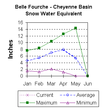
ANGOSTURA                              122.1    105.5    111.1     96.4 |   BELLE FOURCHE               4       163        68
                                                                        |
BELLE FOURCHE                          178.4    173.1    166.7     90.6 |
                                                                        |
DEERFIELD                               15.2     14.8     14.3     12.3 |
                                                                        |
KEYHOLE                                193.8    171.9    176.8     98.2 |
                                                                        |
PACTOLA                                 55.0     54.6     51.5     45.8 |
                                                                        |
SHADEHILL                               81.4     55.7     57.8     50.7 |
                                                                        |
==================================================================================================================================
 * 90%, 70%, 30%, and 10% chances of exceeding are the probabilities that the actual volume will exceed the volumes in the 
table.

The average is computed for the 1961-1990 base period.

(1) - The values listed under the 10% and 90% Chance of Exceeding are actually 5% and 95% exceedance levels.                  
(2) - The value is natural volume - actual volume may be affected by upstream water management.
(3) - Forecasts produced in cooperation with Alberta Forecasting Staff Canada


To January 2000 Basin Outlook Report Contents Page