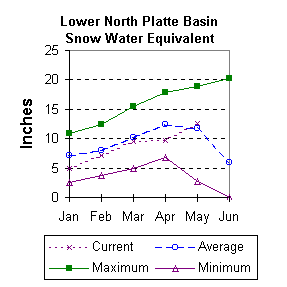
Lower North Platte River Basin (9)
May 1999

Snow
Most areas in the basin have received near normal snow for this time of year. SWE for the North Platte River basin in Wyoming averages 108 percent of normal (122 % of last year). The Sweetwater drainage is currently 137 percent of average (158 % of last year). SWE for the Deer and LaPrele Creeks are 130 percent of average (170 percent of last year). SWE for the North Platte above the Laramie River drainage is 107 percent of average (124 % of last year). SWE for the Laramie River above the mouth is 100 percent of average (111 % of last year). SWE for the Laramie River above Laramie is 100 percent of average (112 % of last year). And SWE in the Little Laramie River is 101 percent of normal (112 percent of last year). For more information see Basin Summary of Snow Courses at beginning of report.

Precipitation
Of the 7 reporting stations, percentages for the month range from 97 to 366. April precipitation for the basin was 188 percent of average (271 percent of last year). The water year-to-date precipitation for the basin is currently 127 percent of average (146 percent of last year). Year to date percentages range from 110 to 144.

Reservoir
Lower North Platte River basin reservoir storage is average to well above average. Reservoir storage is as follows: Alcova 179,000 acre feet (99 percent of average); Glendo 527,700 acre feet (115 percent of average); Guernsey 37,200 acre feet (113 percent of average); Pathfinder 995,300 acre feet (163 percent of average); Seminoe 719,800 acre feet (163 percent of average); and Wheatland No.2 76,000 acre feet (138 percent of average). Water allocated to project use is also above average with North Platte Project users at 135 percent of average, Kendrick Project users at 128 percent of average, and Glendo Project users at 134 percent of average.

Streamflow
Yields from 48 to 114 percent are expected in the basin during the forecast period. The following yields are based on the fifty percent chance probability runoff for the May through September forecast period. The Sweetwater near Alcova is forecast to yield about 150,000 acre-feet (246 percent of average). Deer Creek at Glenrock is expected to yield about 103 percent of average (31,000 acre-feet). LaPrele Creek above the reservoir is estimated to yield 110 percent of average (22,000 acre-feet). North Platte River below Guernsey Reservoir is expected to yield about 94 percent of normal (929,000 acre-feet), and below Glendo Reservoir is anticipated to yield about 93 percent of average (892,000 acre-feet). Laramie River near Woods should yield about 110 percent of average (140,000 acre-feet). The Little Laramie near Filmore should produce about 61,000 acre-feet (100 percent of average).

==================================================================================================================================
                                      LOWER NORTH PLATTE, SWEETWATER & LARAMIE RIVER BASINS
                                               Streamflow Forecasts - May 1, 1999
==================================================================================================================================
                                              |  <<====== Drier ======  Future Conditions  =======  Wetter =====>>  |             
                                              |                                                                     |
  Forecast Point                     Forecast |  ==================== Chance Of Exceeding * ======================  |
                                      Period  |    90%       70%    |  50% (Most Probable)  |      30%       10%    |  30-Yr Avg.
                                              | (1000AF)  (1000AF)  |   (1000AF)  (% AVG.)  |    (1000AF)  (1000AF) |    (1000AF)
====================================================================|=======================|=====================================
Sweetwater River nr Alcova           MAY-JUL       117       131    |      140       250    |       149       163             56
                                     MAY-SEP       125       140    |      150       246    |       160       175             61
                                                                    |                       |
Deer Creek at Glenrock               MAY-SEP        23        28    |       31       103    |        35        41             30
                                                                    |                       |
La Prele Creek ab La Prele Reservoir MAY-SEP       8.3      15.4    |       22       110    |        30        46             20
                                                                    |                       |
North Platte River blw Glendo        APR-SEP       847              |      892        93    |                1396            963
                                                                    |                       |
North Platte River blw Guernsey      APR-SEP       880              |      929        94    |                1444            989
                                                                    |                       |
Laramie River nr Woods               MAY-SEP        95       122    |      140       110    |       158       185            127
                                                                    |                       |
Little Laramie River nr Filmore      MAY-SEP        52        57    |       61       100    |        65        71             61
                                                                    |                       |
==================================================================================================================================
          LOWER NORTH PLATTE, SWEETWATER & LARAMIE RIVER BASINS         |  LOWER NORTH PLATTE, SWEETWATER & LARAMIE RIVER BASINS
             Reservoir Storage (1000 AF) - End of April                 |        Watershed Snowpack Analysis - May 1, 1999
==================================================================================================================================
                                      Usable |  *** Usable Storage ***  |                            Number     This Year as % of
Reservoir                            Capacity|  This      Last          |   Watershed                  of       =================
                                             |  Year      Year     Avg  |                          Data Sites   Last Yr   Average
========================================================================|=========================================================
ALCOVA                                 184.3    179.0    179.6    179.9 |   SWEETWATER                  3       158       137
                                                                        |
GLENDO                                 506.4    527.7    473.7    457.6 |   DEER & LaPRELE CREEKS       4       170       130
                                                                        |
GUERNSEY                                45.6     37.2     31.7     32.8 |   N PLATTE abv Laramie R.    27       124       107
                                                                        |
PATHFINDER                            1016.5    995.3    982.3    609.0 |   LARAMIE RIVER abv Laramie   9       112       100
                                                                        |
SEMINOE                               1016.7    719.8    690.4    392.0 |   LITTLE LARAMIE RIVER        4       112       101
                                                                        |
WHEATLAND #2                            98.9     76.0     79.0     54.9 |   LARAMIE RIVER above mouth  12       111       100
                                                                        |
NORTH PLATTE PROJ                     1062.1   1061.8   1102.6    786.7 |   NORTH PLATTE               35       122       108
                                                                        |
KENDRICK PROJECT                      1201.7   1031.3    959.3    807.0 |
                                                                        |
GLENDO PROJECT USERS                   183.2    172.2    167.0    128.9 |
                                                                        |
==================================================================================================================================
 * 90%, 70%, 30%, and 10% chances of exceeding are the probabilities that the actual volume will exceed the volumes in the table.

The average is computed for the 1961-1990 base period.

(1) - The values listed under the 10% and 90% Chance of Exceeding are actually 5% and 95% exceedance levels.                  
(2) - The value is natural volume - actual volume may be affected by upstream water management.


To May 1999 Basin Outlook Report Contents Page