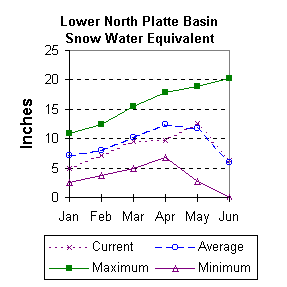
Lower North Platte River Basin (9)
June 1999

Snow
Cool weather has slowed the normal melting of snow -- consequently the comparison to average, and last year, could appear exaggerated. SWE for the North Platte River basin in Wyoming averages 126 percent of normal (189 % of last year). The Sweetwater drainage is currently 146 percent of average (3650 % of last year). Deer and LaPrele Creeks are melted out as of June 1. SWE for the North Platte above the Laramie River drainage is 126 percent of average (186 % of last year). SWE for the Laramie River above the mouth is 118 percent of average (286 % of last year). SWE for the Laramie River above Laramie is 111 percent of average (249 % of last year). And SWE in the Little Laramie River is 137 percent of normal (427 % of last year). For more information see Basin Summary of Snow Courses at beginning of report.

Precipitation
Of the 7 reporting stations, percentages for the month range from 47 to 178. May precipitation for the basin was 103 percent of average (246 percent of last year). The water year-to-date precipitation for the basin is currently 123 percent of average (154 percent of last year). Year to date percentages range from 109 to 131.

Reservoir
Lower North Platte River basin reservoir storage is average to well above average. Reservoir storage is as follows: Alcova 179,100 acre feet (99 percent of average); Glendo 553,400 acre feet (110 percent of average); Guernsey 33,800 acre feet (98 percent of average); Pathfinder 993,300 acre feet (156 percent of average); Seminoe 842,900 acre feet (153 percent of average); and Wheatland No.2 90,000 acre feet (165 percent of average). Water allocated to project use is also above average with North Platte Project users at 117 percent of average, Kendrick Project users at 124 percent of average, and Glendo Project users at 115 percent of average.

Streamflow
Yields from 100 to 194 percent are expected in the basin during the forecast period. The following yields are based on the fifty percent chance probability runoff for the June through September forecast period. The Sweetwater near Alcova is forecast to yield about 65,000 acre-feet (181 percent of average). Deer Creek at Glenrock is expected to yield about 152 percent of average (11,000 acre-feet). LaPrele Creek above the reservoir is estimated to yield 129 percent of average (8,000 acre-feet). North Platte River below Guernsey Reservoir is expected to yield about 132 percent of normal (630,000 acre-feet), and below Glendo Reservoir is anticipated to yield about 130 percent of average (604,000 acre-feet). Laramie River near Woods should yield about 127 percent of average (113,000 acre-feet). The Little Laramie near Filmore should produce about 48,000 acre-feet (100 percent of average).

==================================================================================================================================
                                      LOWER NORTH PLATTE, SWEETWATER & LARAMIE RIVER BASINS
                                               Streamflow Forecasts - June 1, 1999
==================================================================================================================================
                                              |  <<====== Drier ======  Future Conditions  =======  Wetter =====>>  |             
                                              |                                                                     |
  Forecast Point                     Forecast |  ==================== Chance Of Exceeding * ======================  |
                                      Period  |    90%       70%    |  50% (Most Probable)  |      30%       10%    |  30-Yr Avg.
                                              | (1000AF)  (1000AF)  |   (1000AF)  (% AVG.)  |    (1000AF)  (1000AF) |    (1000AF)
====================================================================|=======================|=====================================
Sweetwater River nr Alcova           JUN-JUL        52        56    |       60       194    |        64        70             31
                                     JUN-SEP        52        60    |       65       181    |        70        77             36
                                                                    |                       |
Deer Creek at Glenrock               JUN-SEP      6.31      8.95    |    11.00       152    |     13.26     16.98           7.25
                                                                    |                       |
La Prele Creek ab La Prele Reservoir JUN-SEP      3.33      5.78    |     8.00       129    |     10.72     15.76           6.20
                                                                    |                       |
North Platte River blw Glendo        JUN-SEP       478              |      604       130    |                 752            464
                                                                    |                       |
North Platte River blw Guernsey      JUN-SEP       500              |      630       132    |                 781            476
                                                                    |                       |
Laramie River nr Woods               JUN-SEP        84       101    |      113       127    |       125       142             89
                                                                    |                       |
Little Laramie River nr Filmore      JUN-SEP        39        45    |       48       100    |        52        57             48
                                                                    |                       |
==================================================================================================================================
          LOWER NORTH PLATTE, SWEETWATER & LARAMIE RIVER BASINS         |  LOWER NORTH PLATTE, SWEETWATER & LARAMIE RIVER BASINS
             Reservoir Storage (1000 AF) - End of May                   |        Watershed Snowpack Analysis - June 1, 1999
==================================================================================================================================
                                      Usable |  *** Usable Storage ***  |                            Number     This Year as % of
Reservoir                            Capacity|  This      Last          |   Watershed                  of       =================
                                             |  Year      Year     Avg  |                          Data Sites   Last Yr   Average
========================================================================|=========================================================
ALCOVA                                 184.3    179.1    180.5    180.4 |   SWEETWATER                  1       3650      146
                                                                        |
GLENDO                                 506.4    553.4    467.3    501.0 |   DEER & LaPRELE CREEKS       2         0         0
                                                                        |
GUERNSEY                                45.6     33.8     34.1     34.5 |   N PLATTE abv Laramie R.    16       186       126
                                                                        |
PATHFINDER                            1016.5    993.3    971.2    638.0 |   LARAMIE RIVER abv Laramie   3       249       111
                                                                        |
SEMINOE                               1016.7    842.9    777.2    551.0 |   LITTLE LARAMIE RIVER        1       427       137
                                                                        |
WHEATLAND #2                            98.9     90.0     71.0     54.6 |   LARAMIE RIVER above mouth   4       286       118
                                                                        |
NORTH PLATTE PROJ                     1062.1   1061.5   1056.8    909.8 |   NORTH PLATTE               17       189       126
                                                                        |
KENDRICK PROJECT                      1201.7   1047.4   1037.6    844.4 |
                                                                        |
GLENDO PROJECT USERS                   183.2    172.2    167.1    149.7 |
                                                                        |
==================================================================================================================================
 * 90%, 70%, 30%, and 10% chances of exceeding are the probabilities that the actual volume will exceed the volumes in the table.

The average is computed for the 1961-1990 base period.

(1) - The values listed under the 10% and 90% Chance of Exceeding are actually 5% and 95% exceedance levels.                  
(2) - The value is natural volume - actual volume may be affected by upstream water management.


To June 1999 Basin Outlook Report Contents Page