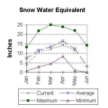
Streamflow
The 50 percent chance stream flow yields are expected to be below average in
the Bear River drainage. The Bear River near the Utah-Wyoming State Line is
expected to yield 109,000 acre feet; that is 91 percent of average for the May
to September period. The Thomas Fork drainage is estimated to yield 24,000 acre
feet or 80 percent of normal for the May-September period. The 50 percent
chance yield for Smiths Fork near Border is about 98,000 acre feet (90 percent
of normal) for the May-September period. The Bear River near Woodruff is
expected to yield 115,000 acre feet, about 91 percent of normal for the May-July period.
==================================================================================================================================
                                                      UPPER BEAR RIVER BASIN
                                               Streamflow Forecasts - May 1, 1998
==================================================================================================================================
                                              |  <<====== Drier ======  Future Conditions  =======  Wetter =====>>  |
                                              |                                                                     |
  Forecast Point                     Forecast |  ==================== Chance Of Exceeding * ======================  |
                                      Period  |    90%       70%    |  50% (Most Probable)  |      30%       10%    |  30-Yr Avg.
                                              | (1000AF)  (1000AF)  |   (1000AF)  (% AVG.)  |    (1000AF)  (1000AF) |    (1000AF)
====================================================================|=======================|=====================================
SMITHS FK nr Border, WY              MAY-SEP        77        89    |       98        90    |       108       124            109
                                                                    |                       |
THOMAS FK nr WY-ID State Line        MAY-SEP      15.3        20    |       24        80    |        29        38             30
                                                                    |                       |
Bear R nr UT-WY State Line           APR-SEP       101       109    |      115        91    |       121       131            126
                                     MAY-SEP        95       103    |      109        91    |       115       125            120
                                                                    |                       |
BEAR R nr Woodruff, UT               APR-SEP        90       117    |      139        90    |       165       214            154
                                     MAY-JUL        74        96    |      115        91    |       138       179            126
                                                                    |                       |
==================================================================================================================================
                         UPPER BEAR RIVER BASIN                         |                 UPPER BEAR RIVER BASIN
             Reservoir Storage (1000 AF) - End of April                 |        Watershed Snowpack Analysis - May 1, 1998
==================================================================================================================================
                                      Usable |  *** Usable Storage ***  |                            Number     This Year as % of
Reservoir                            Capacity|  This      Last          |   Watershed                  of       =================
                                             |  Year      Year     Avg  |                          Data Sites   Last Yr   Average
========================================================================|=========================================================
WOODRUFF NARROWS                        57.3     57.3     57.3      --- |   UPPER BEAR RIVER in Utah    5        73       114
                                                                        |
                                                                        |   SMITHS & THOMAS FORKS       4        59        89
                                                                        |
                                                                        |   BEAR RIVER abv ID line      9        62        97
                                                                        |
==================================================================================================================================
 * 90%, 70%, 30%, and 10% chances of exceeding are the probabilities that the actual volume will exceed the volumes in the table.

The average is computed for the 1961-1990 base period.

(1) - The values listed under the 10% and 90% Chance of Exceeding are actually 5% and 95% exceedance levels.
(2) - The value is natural volume - actual volume may be affected by upstream water management.
 To May 1998 Basin Outlook Report Contents Page