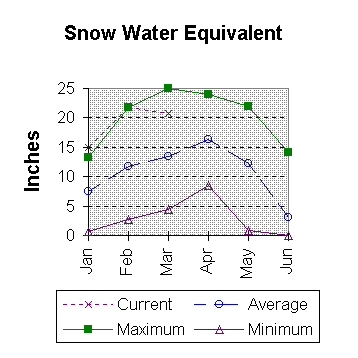
Streamflow
The 50 percent chance April - September stream flow yields are
expected to be much above average in the Bear River drainage. The
Bear River at the Utah State Line is expected to yield 186,000 acre feet;
that is about 48 percent more than average. The Thomas Fork drainage
is estimated to yield 68,000 acre feet or 89 percent more than normal
for the April -- September period. The 50 percent chance yield for
Smiths Fork near Border is about 200,000 acre feet (69 percent more
than normal) for the April - September period. The Bear River near
Woodruff is expected to yield about 225,000 acre feet, about 51 percent
more than normal for the April-July period.
==================================================================================================================================
                                                      UPPER BEAR RIVER BASIN
                                               Streamflow Forecasts - March 1, 1997
==================================================================================================================================
                                              |  <<====== Drier ======  Future Conditions  =======  Wetter =====>>  |
                                              |                                                                     |
  Forecast Point                     Forecast |  ==================== Chance Of Exceeding * ======================  |
                                      Period  |    90%       70%    |  50% (Most Probable)  |      30%       10%    |  30-Yr Avg.
                                              | (1000AF)  (1000AF)  |   (1000AF)  (% AVG.)  |    (1000AF)  (1000AF) |    (1000AF)
====================================================================|=======================|=====================================
SMITHS FORK nr Border, WY            APR-SEP       164       185    |      200       170    |       215       236            118
                                                                    |                       |
THOMAS FK nr WY-ID State Line        APR-SEP        37        53    |       68       189    |        87       124             36
                                                                    |                       |
BEAR R nr UT-WY State Line           APR-SEP       135       163    |      186       148    |       212       257            126
                                                                    |                       |
BEAR R nr Woodruff (2)               APR-JUL       119       182    |      225       151    |       268       331            149
                                                                    |                       |
==================================================================================================================================
                         UPPER BEAR RIVER BASIN                         |                 UPPER BEAR RIVER BASIN
             Reservoir Storage (1000 AF) - End of February              |        Watershed Snowpack Analysis - March 1, 1997
==================================================================================================================================
                                      Usable |  *** Usable Storage ***  |                            Number     This Year as % of
Reservoir                            Capacity|  This      Last          |   Watershed                  of       =================
                                             |  Year      Year     Avg  |                          Data Sites   Last Yr   Average
========================================================================|=========================================================
WOODRUFF NARROWS                        57.3     30.2     45.0      --- |   UPPER BEAR RIVER in Utah    5       112       150
                                                                        |
                                                                        |   SMITHS & THOMAS FORKS       4       122       152
                                                                        |
                                                                        |   BEAR RIVER abv ID line     11       120       155
                                                                        |
==================================================================================================================================
 * 90%, 70%, 30%, and 10% chances of exceeding are the probabilities that the actual flow will exceed the volumes in the table.

The average is computed for the 1961-1990 base period.

(1) - The values listed under the 10% and 90% Chance of Exceeding are actually 5% and 95% exceedance levels.
(2) - The value is natural flow - actual flow may be affected by upstream water management.
 To March 1997 Basin Outlook Report Contents Page