Wind River Basin (3)
June 1997

Snow
The Wind River basin has about average snow water equivalent (SWE) for this time of the year. The Wind River basin above Boysen Reservoir averages about 8 percent above normal (SWE) for June 1. Above Dubois, the water content is about 5% above normal for this time of the year, while the Popo Agie drainage is about 3% and the Little Wind is about 34% above normal. All drainages are well above last year at this time. See the Basin Summary Of Snow Course Data at the front of this report for details.

Precipitation
May precipitation in the basin, varied from 49 percent of average at Pavillion to 158 percent of average for Boysen Dam. May's average precipitation for the basin was below normal (13 percent below average for the 13 reporting stations); that is about 36 percent less than last years amount. Water year-to-date precipitation is 22 percent more than normal. The current water-year-to-date average is about 6 percent more than last year at this time.

Reservoirs
Current storage varies from 77 to 105 percent of average. Current storage, compared to average for the three storage reservoirs in the basin, is as follows; Bull Lake 105% (97,500 acre feet), Boysen 77% (420,900 acre feet), and Pilot Butte 87% (22,200 acre feet). Bull Lake is about 13 percent above last year's storage amount, while Boysen is 7 percent less and Pilot Butte is 14 percent more than last year at this time.

Streamflow
There should be an adequate water supply this year. Excessive flows can be expected in portions of the basin this spring. In the upper portion of the drainage, Wind River near Dubois is expected to yield about 90,000 acre feet (about 22 percent above normal) during the June to September period. Other forecast points on the Wind River drainage include Wind River above Bull Lake 500,000 acre feet (19% above normal), Wind River at Riverton 620,000 acre feet (23% above average), and below Boysen 750,000 acre feet (23 % above normal). Bull Lake Creek near Lenore is expected to yield about 165,000 acre feet (7% above normal), Little Popo Agie River near Lander about 45,000 acre feet (22% above normal), South Fork of Little Wind near Fort Washakie about 70,000 acre feet (11% above normal), and Little Wind River near Riverton about 290,000 acre feet (20 percent more than normal). All forecasts are for the June to September period.

==================================================================================================================================
                                                         WIND RIVER BASIN
                                               Streamflow Forecasts - June 1, 1997
==================================================================================================================================
                                              |  <<====== Drier ======  Future Conditions  =======  Wetter =====>>  |             
                                              |                                                                     |
  Forecast Point                     Forecast |  ==================== Chance Of Exceeding * ======================  |
                                      Period  |    90%       70%    |  50% (Most Probable)  |      30%       10%    |  30-Yr Avg.
                                              | (1000AF)  (1000AF)  |   (1000AF)  (% AVG.)  |    (1000AF)  (1000AF) |    (1000AF)
====================================================================|=======================|=====================================
WIND RIVER near Dubois               JUN-SEP        77        85    |       90       122    |        95       103             74
                                                                    |                       |
WIND RIVER abv Bull Lake Cr (2)      JUN-SEP       423       469    |      500       119    |       531       577            420
                                                                    |                       |
WIND RIVER at Riverton (2)           JUN-SEP       488       566    |      620       123    |       674       752            505
                                                                    |                       |
WIND RIVER below Boysen (2)          JUN-SEP       543       666    |      750       123    |       834       957            609
                                                                    |                       |
BULL LAKE CREEK near Lenore (2)      JUN-SEP       137       154    |      165       107    |       176       193            154
                                                                    |                       |
LITTLE POPO AGIE RIVER near Lander   JUN-SEP        34        41    |       45       122    |        50        56             37
                                                                    |                       |
SF LITTLE WIND RIVER near Fort Washa JUN-SEP        59        66    |       70       111    |        75        81             63
                                                                    |                       |
LITTLE WIND RIVER near Riverton      JUN-SEP       248       273    |      290       120    |       307       332            241
                                                                    |                       |
==================================================================================================================================
                            WIND RIVER BASIN                            |                    WIND RIVER BASIN
             Reservoir Storage (1000 AF) - End of May                   |        Watershed Snowpack Analysis - June 1, 1997
==================================================================================================================================
                                      Usable |  *** Usable Storage ***  |                            Number     This Year as % of
Reservoir                            Capacity|  This      Last          |   Watershed                  of       =================
                                             |  Year      Year     Avg  |                          Data Sites   Last Yr   Average
========================================================================|=========================================================
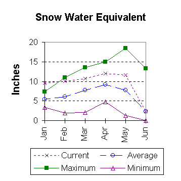
BULL LAKE                              151.8     97.5     86.0     92.7 |   WIND RIVER above Dubios     3        47       105
                                                                        |
BOYSEN                                 596.0    420.9    454.2    546.4 |   LITTLE WIND                 2        77       134
                                                                        |
PILOT BUTTE                             31.6     22.2     19.4     25.5 |   POPO AGIE                   4        86       103
                                                                        |
                                                                        |   WIND above Boysen Resv      8        62       103
                                                                        |
==================================================================================================================================
 * 90%, 70%, 30%, and 10% chances of exceeding are the probabilities that the actual volume will exceed the volumes in the table.

The average is computed for the 1961-1990 base period.

(1) - The values listed under the 10% and 90% Chance of Exceeding are actually 5% and 95% exceedance levels.                  
(2) - The value is natural volume - actual volume may be affected by upstream water management.


To June 1997 Basin Outlook Report Contents Page