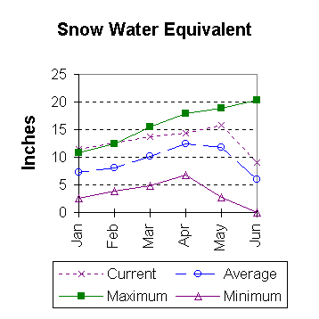
Lower North Platte River Basin (9)
June 1997

Snow
The above average snowpacks across the basin have been coming out very fast. This has lowered the percent of average snow ahead of average. Deer and LaPrele Creeks are currently at 105 percent of average. The Sweetwater drainage is currently just 97 percent. The North Platte above the Laramie river drainage is 35 percent above average. The basin average SWE is now 134 percent of normal. This is 10 percent ahead of what it was last year at this time. For more information see Basin Summary of Snow Courses at beginning of report.

Precipitation
May precipitation in the basin varied quite a lot. Of the reporting stations, South Pass came in with 62 percent of average precipitation for the month, while Douglas Aviation reported 324 percent of the May average. May precipitation for the basin was 109 percent of average (91 percent of last year). The water year-to-date precipitation for the basin is currently 118 percent of average (18 percent ahead of last year).

Reservoir
Basin Reservoir storage is in good shape. Storage at all of the reservoirs is near average to well above average. Reservoir storage is as follows: Alcova 180,300 acre feet (100 percent of average), Glendo 507,700 acre feet (101 percent of average), Guernsey 35,100 acre feet (102 percent of normal), Pathfinder 956,300 acre feet (150 percent of average), Seminoe 785,400 acre feet (143 percent of average), and Wheatland No. Two 63,000 acre feet (115 percent of average).

Streamflow
At this time, above average yields are expected over the entire basin during the April to September forecast period. All the following values are based on the fifty percent chance probability runoff. The Deer Creek drainage is expected to flow at 139 percent of average (54,000 acre feet). Below Guernsey, the North Platte River should flow near 133 percent of average (1,311,000 acre feet). The Sweetwater is forecast to flow 115,000 acre feet (158 percent of average). LaPrele Creek should yield 132 percent of average (33,000 acre feet). North Platte below Glendo should yield about 131 percent of average (1,260,000 acre feet). Laramie River near Woods should yield about 133 percent of average (180,000 acre feet). The Little Laramie near Filmore should flow 80,000 acre feet (125 percent of average).

==================================================================================================================================
                                      LOWER NORTH PLATTE, SWEETWATER & LARAMIE RIVER BASINS
                                               Streamflow Forecasts - June 1, 1997
==================================================================================================================================
                                              |  <<====== Drier ======  Future Conditions  =======  Wetter =====>>  |             
                                              |                                                                     |
  Forecast Point                     Forecast |  ==================== Chance Of Exceeding * ======================  |
                                      Period  |    90%       70%    |  50% (Most Probable)  |      30%       10%    |  30-Yr Avg.
                                              | (1000AF)  (1000AF)  |   (1000AF)  (% AVG.)  |    (1000AF)  (1000AF) |    (1000AF)
====================================================================|=======================|=====================================
SEMINOE RESERVOIR INFLOW             APR-JUL      1023      1092    |     1140       143    |      1188      1257            800
                                                                    |                       |
SWEETWATER RIVER nr Alcova           APR-JUL        82        97    |      108       157    |       120       138             69
                                     APR-SEP        90       105    |      115       158    |       125       140             73
                                                                    |                       |
DEER CREEK at Glenrock               APR-SEP        38        48    |       54       139    |        61        70             39
                                                                    |                       |
LaPRELE CREEK above Reservoir        APR-SEP        22        29    |       33       132    |        37        44             25
                                                                    |                       |
NORTH PLATTE RIVER blw Glendo        APR-SEP      1079              |     1260       131    |                1454            963
                                                                    |                       |
NORTH PLATTE R. blw Guernsey         APR-SEP      1127              |     1311       133    |                1523            989
                                                                    |                       |
LARAMIE RIVER near Woods             APR-SEP       147       167    |      180       133    |       193       213            135
                                                                    |                       |
LITTLE LARAMIE RIVER near Filmore    APR-SEP        67        75    |       80       125    |        85        93             64
                                                                    |                       |
==================================================================================================================================
          LOWER NORTH PLATTE, SWEETWATER & LARAMIE RIVER BASINS         |  LOWER NORTH PLATTE, SWEETWATER & LARAMIE RIVER BASINS
             Reservoir Storage (1000 AF) - End of May                   |        Watershed Snowpack Analysis - June 1, 1997
==================================================================================================================================
                                      Usable |  *** Usable Storage ***  |                            Number     This Year as % of
Reservoir                            Capacity|  This      Last          |   Watershed                  of       =================
                                             |  Year      Year     Avg  |                          Data Sites   Last Yr   Average
========================================================================|=========================================================
ALCOVA                                 184.3     18.3    179.4    180.4 |   SWEETWATER                  2        93        97
                                                                        |
GLENDO                                 506.4    507.7    532.0    501.0 |   DEER & LaPRELE CREEKS       2       186       105
                                                                        |
GUERNSEY                                45.6     35.1     36.7     34.5 |   N PLATTE abv Laramie R.    17       111       135
                                                                        |
PATHFINDER                            1016.5    956.3    952.7    638.0 |   LARAMIE RIVER abv Laramie   3       100       121
                                                                        |
SEMINOE                               1016.7    785.4    780.8    551.0 |   LITTLE LARAMIE RIVER        1        93       142
                                                                        |
WHEATLAND #2                            98.9     63.0     66.3     54.6 |   LARAMIE RIVER above mouth   4        98       127
                                                                        |
NORTH PLATTE PROJ                     1062.1   1052.9   1049.9    909.8 |   NORTH PLATTE               18       110       134
                                                                        |
KENDRICK PROJECT                      1201.7   1022.0   1025.2    844.4 |
                                                                        |
GLENDO PROJECT USERS                   183.2    164.6    172.2    149.7 |
                                                                        |
==================================================================================================================================
 * 90%, 70%, 30%, and 10% chances of exceeding are the probabilities that the actual volume will exceed the volumes in the table.

The average is computed for the 1961-1990 base period.
(1) - The values listed under the 10% and 90% Chance of Exceeding are actually 5% and 95% exceedance levels.                  
(2) - The value is natural volume - actual volume may be affected by upstream water management.

To June 1997 Basin Outlook Report Contents Page