Streamflow
Runoff from all drainages should be much above average this season. The fifty
percent yield (April to September Period) for North Fork at Wapiti is expected
to be 850,000 acre feet (64 percent more than normal). South Fork of the
Shoshone near Valley has an estimated 50 percent chance yield of about 415,000
acre feet (54 percent above normal) and at Buffalo Bill Reservoir the fifty
percent chance yield it is expected to be 365,000 (59 percent more than
normal). Below Buffalo Bill Reservoir, the fifty percent chance yield for the
Shoshone River is expected to be about 1,250,000 acre feet (56 percent above
average). The fifty percent chance yield for the Clarks Fork of the
Yellowstone near Belfry, Montana is expected to be about 810,000 acre feet
(37 percent above average).
==================================================================================================================================
SHOSHONE & CLARKS FORK RIVER BASINS
Streamflow Forecasts - January 1, 1997
==================================================================================================================================
| <<====== Drier ====== Future Conditions ======= Wetter =====>> |
| |
Forecast Point Forecast | ==================== Chance Of Exceeding * ====================== |
Period | 90% 70% | 50% (Most Probable) | 30% 10% | 30-Yr Avg.
| (1000AF) (1000AF) | (1000AF) (% AVG.) | (1000AF) (1000AF) | (1000AF)
====================================================================|=======================|=====================================
NF SHOSHONE RIVER at Wapiti APR-SEP 706 792 | 850 164 | 908 994 520
| |
SF SHOSHONE RIVER near Valley APR-SEP 346 387 | 415 154 | 443 484 269
| |
SF SHOSHONE RIVER abv Buffalo Bill APR-SEP 274 328 | 365 159 | 402 456 229
| |
SHOSHONE RIVER blw Buffalo Bill (2) APR-SEP 1047 1163 | 1250 156 | 1337 1350 799
| |
CLARKS FORK RIVER near Belfry APR-SEP 655 747 | 810 137 | 873 965 590
| |
==================================================================================================================================
SHOSHONE & CLARKS FORK RIVER BASINS | SHOSHONE & CLARKS FORK RIVER BASINS
Reservoir Storage (1000 AF) - End of December | Watershed Snowpack Analysis - January 1, 1997
==================================================================================================================================
Usable | *** Usable Storage *** | Number This Year as % of
Reservoir Capacity| This Last | Watershed of =================
| Year Year Avg | Data Sites Last Yr Average
========================================================================|=========================================================
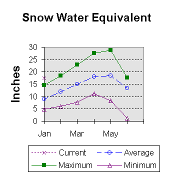
BUFFALO BILL 646.6 512.1 528.6 436.7 | SHOSHONE RIVER 5 115 197
|
| CLARKS FORK in WY 7 124 196
|
==================================================================================================================================
* 90%, 70%, 30%, and 10% chances of exceeding are the probabilities that the actual flow will exceed the volumes in the table.
The average is computed for the 1961-1990 base period.
(1) - The values listed under the 10% and 90% Chance of Exceeding are actually 5% and 95% exceedance levels.
(2) - The value is natural flow - actual flow may be affected by upstream water management.
 To Jaunary 1997 Basin Outlook Report Contents Page