Lower North Platte River Basin
January 1997

Snow
Higher than normal snowfall across the basin has caused near record snow water equivalent (SWE). Deer and LaPrele Creeks are currently at 196 percent of average. The Sweetwater drainage is close behind with 187 percent. The Laramie River drainage is about 41 percent above average. The basin average SWE is now 156 percent of normal. This is 43 percent ahead of what it was last year at this time. For more information see Basin Summary of Snow Courses at beginning of report.

Precipitation
December precipitation in the basin varied quite a lot. Of the reporting stations, Carpenter came in with no precipitation for the month, while South Pass City reported 473 percent of the December average. Three stations reported over 400 percent for the month, 2 SNOTEL and the National Weather Service site at South Pass City. December precipitation for the basin was 213 percent of average (244 percent of last year). The water year-to-date precipitation for the basin is currently 151 percent of average (26 percent ahead of last year).

Reservoir
Basin Reservoir storage is in good shape. Storage at all of the reservoirs is near average to well above average. Reservoir storage is as follows: Alcova 154,400 acre feet (101 percent of average), Glendo 257,200 acre feet (93 percent of average), Guernsey 11,700 acre feet (213 percent of normal), Pathfinder 831,800 acre feet (165 percent of average), Seminoe 744,800 acre feet (137 percent of average), and Wheatland No. Two 48,000 acre feet (no average established).

Streamflow
At this time, above average yields are expected over the entire basin during the April to September forecast period. All the following values are based on the fifty percent chance probability runoff. The highest forecast is the Sweetwater Drainage at 219 percent of average (160,000 acre feet). Below Guernsey, the North Platte River should flow near 129 percent of average (1,280,000 acre feet). Deer Creek is forecast to flow 70,000 acre feet (180 percent of average). LaPrele Creek should yield 160 percent of average (40,000 acre feet). North Platte below Glendo should yield about 128 percent of average (1,230,000 acre feet). Laramie River near Woods should yield about 119 percent of average (160,000 acre feet). The Little Laramie near Filmore should flow 80,000 acre feet (125 percent of average).

==================================================================================================================================
                                      LOWER NORTH PLATTE, SWEETWATER & LARAMIE RIVER BASINS
                                               Streamflow Forecasts - January 1, 1997
==================================================================================================================================
                                              |  <<====== Drier ======  Future Conditions  =======  Wetter =====>>  |             
                                              |                                                                     |
  Forecast Point                     Forecast |  ==================== Chance Of Exceeding * ======================  |
                                      Period  |    90%       70%    |  50% (Most Probable)  |      30%       10%    |  30-Yr Avg.
                                              | (1000AF)  (1000AF)  |   (1000AF)  (% AVG.)  |    (1000AF)  (1000AF) |    (1000AF)
====================================================================|=======================|=====================================
SWEETWATER RIVER nr Alcova           APR-SEP       115       145    |      160       219    |       175       207             73
                                                                    |                       |
DEER CREEK at Glenrock               APR-SEP        37        57    |       70       180    |        83       103             39
                                                                    |                       |
LaPRELE CREEK above Reservoir        APR-SEP        25        34    |       40       160    |        46        55             25
                                                                    |                       |
NORTH PLATTE RIVER blw Glendo        APR-SEP       761              |     1230       128    |                1685            963
                                                                    |                       |
NORTH PLATTE R. blw Guernsey         APR-SEP       791              |     1280       129    |                1751            989
                                                                    |                       |
LARAMIE RIVER near Woods             APR-SEP        98       135    |      160       119    |       185       222            135
                                                                    |                       |
LITTLE LARAMIE RIVER near Filmore    APR-SEP        50        68    |       80       125    |        92       110             64
                                                                    |                       |
==================================================================================================================================
          LOWER NORTH PLATTE, SWEETWATER & LARAMIE RIVER BASINS         |  LOWER NORTH PLATTE, SWEETWATER & LARAMIE RIVER BASINS
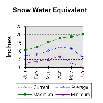
             Reservoir Storage (1000 AF) - End of December              |        Watershed Snowpack Analysis - January 1, 1997
==================================================================================================================================
                                      Usable |  *** Usable Storage ***  |                            Number     This Year as % of
Reservoir                            Capacity|  This      Last          |   Watershed                  of       =================
                                             |  Year      Year     Avg  |                          Data Sites   Last Yr   Average
========================================================================|=========================================================
ALCOVA                                 184.3    154.4    155.0    153.1 |   SWEETWATER                  2       181       187
                                                                        |
GLENDO                                 506.4    257.2    230.1    276.4 |   DEER & LaPRELE CREEKS       2       140       196
                                                                        |
GUERNSEY                                45.6     11.7     14.8      5.5 |   N PLATTE abv Laramie R.    17       148       158
                                                                        |
PATHFINDER                            1016.5    831.8    704.7    505.0 |   LARAMIE RIVER abv Laramie   3       106       132
                                                                        |
SEMINOE                               1016.7    744.8    804.8    542.0 |   LITTLE LARAMIE RIVER        1       161       161
                                                                        |
WHEATLAND #2                            98.9     48.0     63.3      --- |   LARAMIE RIVER above mouth   4       121       141
                                                                        |
NORTH PLATTE PROJ                     1062.1    706.9    939.4    568.4 |   NORTH PLATTE               18       143       156
                                                                        |
KENDRICK PROJECT                      1201.7    982.7    657.3    819.8 |
                                                                        |
GLENDO PROJECT USERS                   183.2    150.1    158.0    116.2 |
                                                                        |
==================================================================================================================================
 * 90%, 70%, 30%, and 10% chances of exceeding are the probabilities that the actual flow will exceed the volumes in the table.

The average is computed for the 1961-1990 base period.

(1) - The values listed under the 10% and 90% Chance of Exceeding are actually 5% and 95% exceedance levels.                  
(2) - The value is natural flow - actual flow may be affected by upstream water management.

To Jaunary 1997 Basin Outlook Report Contents Page