Reservoir
Reservoir storage is in good shape; two reservoirs are just slightly below
average and 4 are above average. Angostura is currently storing 93 percent of
average (89,400 acre feet), Belle Fourche 151 percent of average (136,600 acre
feet), Deerfield is storing 125 percent of average (15,500 acre feet), Keyhole
is storing 144 percent of average (141,800 acre feet), Pactola is storing 118
percent of average (54,200 acre feet), and Shadehill is storing 87 percent of
average (44,100 acre feet).
Streamflow
Runoff could be well above average for the Black Hills if the current trend
continues. Castle Creek is forecast at 153 percent of average flow (7,500
acre feet) for the March - July season. Rapid Creek is even higher at 167
percent of average (35,000 acre feet). Shortages of water should not be a
problem this year in the basin.
==================================================================================================================================
BELLE FOURCHE & CHEYENNE RIVER BASINS
Streamflow Forecasts - January 1, 1997
==================================================================================================================================
| <<====== Drier ====== Future Conditions ======= Wetter =====>> |
| |
Forecast Point Forecast | ==================== Chance Of Exceeding * ====================== |
Period | 90% 70% | 50% (Most Probable) | 30% 10% | 30-Yr Avg.
| (1000AF) (1000AF) | (1000AF) (% AVG.) | (1000AF) (1000AF) | (1000AF)
====================================================================|=======================|=====================================
CASTLE CREEK blw Deerfield Dam (2) MAR-JUL 5.34 6.63 | 7.50 153 | 8.37 9.66 4.90
| |
RAPID CREEK blw Pactola Dam (2) MAR-JUL 21 29 | 35 167 | 41 49 21
| |
==================================================================================================================================
BELLE FOURCHE & CHEYENNE RIVER BASINS | BELLE FOURCHE & CHEYENNE RIVER BASINS
Reservoir Storage (1000 AF) - End of December | Watershed Snowpack Analysis - January 1, 1997
==================================================================================================================================
Usable | *** Usable Storage *** | Number This Year as % of
Reservoir Capacity| This Last | Watershed of =================
| Year Year Avg | Data Sites Last Yr Average
========================================================================|=========================================================
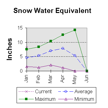
ANGOSTURA 122.1 89.4 90.3 96.4 | BELLE FOURCHE 4 232 179
|
BELLE FOURCHE 178.4 136.6 151.7 90.6 |
|
DEERFIELD 15.2 15.4 14.6 12.3 |
|
KEYHOLE 193.8 141.8 108.0 98.2 |
|
PACTOLA 55.0 54.2 55.3 45.8 |
|
SHADEHILL 81.4 44.1 43.2 50.7 |
|
==================================================================================================================================
* 90%, 70%, 30%, and 10% chances of exceeding are the probabilities that the actual flow will exceed the volumes in the table.
The average is computed for the 1961-1990 base period.
(1) - The values listed under the 10% and 90% Chance of Exceeding are actually 5% and 95% exceedance levels.
(2) - The value is natural flow - actual flow may be affected by upstream water management.
 To Jaunary 1997 Basin Outlook Report Contents Page