Streamflow
Stream flow yields are expected to be much above average in the Bear River
drainage. The 50 percent chance April - September yield forecast for the
Bear River at the Utah State Line is 186,000 acre feet; that is about 48
percent more than average. The Thomas Fork drainage is estimated to yield
68,000 acre feet or 89 percent more than normal for the April -- September
period. The 50 percent chance yield for Smiths Fork near Border is about
200,000 acre feet (69 percent more than normal) for the April - September
period. The Bear River near Woodruff is expected to yield about 225,000
acre feet, about 51 percent more than normal for the April-July period.
==================================================================================================================================
UPPER BEAR RIVER BASIN
Streamflow Forecasts - February 1, 1997
==================================================================================================================================
| <<====== Drier ====== Future Conditions ======= Wetter =====>> |
| |
Forecast Point Forecast | ==================== Chance Of Exceeding * ====================== |
Period | 90% 70% | 50% (Most Probable) | 30% 10% | 30-Yr Avg.
| (1000AF) (1000AF) | (1000AF) (% AVG.) | (1000AF) (1000AF) | (1000AF)
====================================================================|=======================|=====================================
SMITHS FORK nr Border, WY APR-SEP 164 185 | 200 170 | 215 236 118
| |
THOMAS FK nr WY-ID State Line APR-SEP 37 53 | 68 189 | 87 124 36
| |
BEAR R nr UT-WY State Line APR-SEP 135 163 | 186 148 | 212 257 126
| |
BEAR R nr Woodruff (2) APR-JUL 119 182 | 225 151 | 268 331 149
| |
==================================================================================================================================
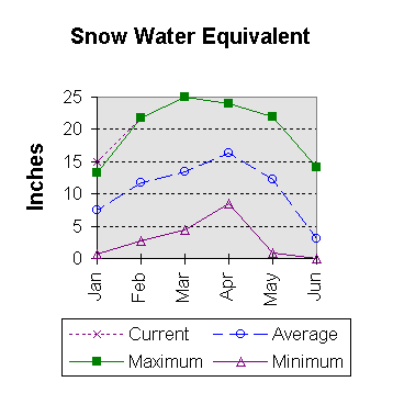
UPPER BEAR RIVER BASIN | UPPER BEAR RIVER BASIN
Reservoir Storage (1000 AF) - End of January | Watershed Snowpack Analysis - February 1, 1997
==================================================================================================================================
Usable | *** Usable Storage *** | Number This Year as % of
Reservoir Capacity| This Last | Watershed of =================
| Year Year Avg | Data Sites Last Yr Average
========================================================================|=========================================================
WOODRUFF NARROWS 57.3 30.2 44.0 --- | UPPER BEAR RIVER in Utah 3 124 179
|
| SMITHS & THOMAS FORKS 4 131 187
|
| BEAR RIVER abv ID line 9 132 188
|
==================================================================================================================================
* 90%, 70%, 30%, and 10% chances of exceeding are the probabilities that the actual flow will exceed the volumes in the table.
The average is computed for the 1961-1990 base period.
(1) - The values listed under the 10% and 90% Chance of Exceeding are actually 5% and 95% exceedance levels.
(2) - The value is natural flow - actual flow may be affected by upstream water management.
 To February 1997 Basin Outlook Report Contents Page