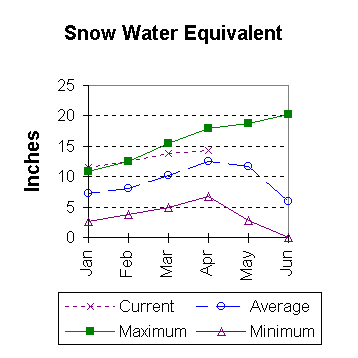
Lower North Platte River Basin
April 1997

Snow
Higher than normal snowfall across the basin has caused near record snow water equivalent (SWE). Deer and LaPrele Creeks are currently at 136 percent of average. The Sweetwater drainage is 131 percent. The North Platte above the Laramie river drainage is 22 percent above average. The basin average SWE is now 119 percent of normal. This is 5 percent ahead of what it was last year at this time. For more information see Basin Summary of Snow Courses at beginning of report.

Precipitation
March precipitation in the basin varied quite a lot. Of the reporting stations, Phillips came in with 17 percent of average precipitation for the month, while South Pass City reported 265 percent of the March average. March precipitation for the basin was 77 percent of average (73 percent of last year). The water year-to-date precipitation for the basin is currently 126 percent of average (16 percent ahead of last year).

Reservoir
Basin Reservoir storage is in good shape. Storage at all of the reservoirs is near average to well above average. Reservoir storage is as follows: Alcova 157,000 acre feet (97 percent of average), Glendo 482,200 acre feet (115 percent of average), Guernsey 28,700 acre feet (133 percent of normal), Pathfinder 905,000 acre feet (146 percent of average), Seminoe 640,300 acre feet (174 percent of average), and Wheatland No. Two 62,000 acre feet (127 percent of average).

Streamflow
At this time, above average yields are expected over the entire basin during the April to September forecast period. All the following values are based on the fifty percent chance probability runoff. The Deer Creek drainage is expected to flow at 139 percent of average (54,000 acre feet). Below Guernsey, the North Platte River should flow near 120 percent of average (1,185,000 acre feet). The Sweetwater is forecast to flow 107,000 acre feet (147 percent of average). LaPrele Creek should yield 116 percent of average (29,000 acre feet). North Platte below Glendo should yield about 118 percent of average (1,139,000 acre feet). Laramie River near Woods should yield about 102 percent of average (138,000 acre feet). The Little Laramie near Filmore should flow 73,000 acre feet (114 percent of average).

==================================================================================================================================
                                      LOWER NORTH PLATTE, SWEETWATER & LARAMIE RIVER BASINS
                                               Streamflow Forecasts - April 1, 1997
==================================================================================================================================
                                              |  <<====== Drier ======  Future Conditions  =======  Wetter =====>>  |             
                                              |                                                                     |
  Forecast Point                     Forecast |  ==================== Chance Of Exceeding * ======================  |
                                      Period  |    90%       70%    |  50% (Most Probable)  |      30%       10%    |  30-Yr Avg.
                                              | (1000AF)  (1000AF)  |   (1000AF)  (% AVG.)  |    (1000AF)  (1000AF) |    (1000AF)
====================================================================|=======================|=====================================
SEMINOE RESERVOIR INFLOW             APR-JUL       848       947    |     1015       127    |      1083      1182            800
                                                                    |                       |
SWEETWATER RIVER nr Alcova           APR-JUL        58        82    |      100       145    |       120       153             69
                                     APR-SEP        85        99    |      107       147    |       126       148             73
                                                                    |                       |
DEER CREEK at Glenrock               APR-SEP        27        43    |       54       139    |        65        81             39
                                                                    |                       |
LaPRELE CREEK above Reservoir        APR-SEP      15.6        24    |       29       116    |        34        42             25
                                                                    |                       |
NORTH PLATTE RIVER blw Glendo        APR-SEP       809              |     1139       118    |                1473            963
                                                                    |                       |
NORTH PLATTE R. blw Guernsey         APR-SEP       841              |     1185       120    |                1533            989
                                                                    |                       |
LARAMIE RIVER near Woods             APR-SEP        90       119    |      138       102    |       157       186            135
                                                                    |                       |
LITTLE LARAMIE RIVER near Filmore    APR-SEP        58        67    |       73       114    |        79        88             64
                                                                    |                       |
==================================================================================================================================
          LOWER NORTH PLATTE, SWEETWATER & LARAMIE RIVER BASINS         |  LOWER NORTH PLATTE, SWEETWATER & LARAMIE RIVER BASINS
             Reservoir Storage (1000 AF) - End of March                 |        Watershed Snowpack Analysis - April 1, 1997
==================================================================================================================================
                                      Usable |  *** Usable Storage ***  |                            Number     This Year as % of
Reservoir                            Capacity|  This      Last          |   Watershed                  of       =================
                                             |  Year      Year     Avg  |                          Data Sites   Last Yr   Average
========================================================================|=========================================================
ALCOVA                                 184.3    157.0    156.7    162.0 |   SWEETWATER                  4       127       131
                                                                        |
GLENDO                                 506.4    482.2    390.0    420.3 |   DEER & LaPRELE CREEKS       4       132       136
                                                                        |
GUERNSEY                                45.6     28.7     25.1     21.6 |   N PLATTE abv Laramie R.    28       109       122
                                                                        |
PATHFINDER                            1016.5    905.0    849.8    619.0 |   LARAMIE RIVER abv Laramie   9        82       103
                                                                        |
SEMINOE                               1016.7    640.3    659.6    368.0 |   LITTLE LARAMIE RIVER        4       107       114
                                                                        |
WHEATLAND #2                            98.9     62.0     68.5     48.7 |   LARAMIE RIVER above mouth  12        90       108
                                                                        |
NORTH PLATTE PROJ                     1062.1    916.7   1083.8    676.0 |   NORTH PLATTE               36       105       119
                                                                        |
KENDRICK PROJECT                      1201.7    924.8    650.6    812.7 |
                                                                        |
GLENDO PROJECT USERS                   183.2    168.5    169.1    127.2 |
                                                                        |
==================================================================================================================================
 * 90%, 70%, 30%, and 10% chances of exceeding are the probabilities that the actual flow will exceed the volumes in the table.

The average is computed for the 1961-1990 base period.


To April 1997 Basin Outlook Report Contents Page