Subscribe to our mailing list
Water Resources Data System
Dept 3943
1000 E. University Ave.
Laramie, WY 82071
wrds@uwyo.edu
Ph (307) 766-6651
Fax (307) 766-3785
At 9:59a, 1/27/20
Temperature 38.8°F
Wind 0.0 mph
|
GIS Web Mapping
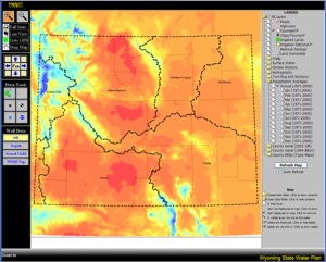
As more and more municipalities, irrigation districts and other water related entities begin to utilize the World Wide Web, the WRDS and the State Climate Office have taken the opportunity to make water and climate data available using customized ArcIMS services. Customized ArcIMS applications allow users to examine numerous aspects of Wyoming water and climate simultaneously, and this approach provides “one stop shopping” for access to important sources of data and information. These efforts are funded by the Wyoming Water Development Office, and these tools will be a key component of updates to the State Water Plan.
 Wyoming Water and Climate Map Server Wyoming Water and Climate Map Server
Important Notes:
- Be sure to disable popup blockers or at least allow popups from .wrds.uwyo.edu before accessing the Map Server.
Please check the documentation of your specific blocker for how to accomplish this.
Not all layers are visible at all scales. Most layers are not visible when zoomed in closer than 1:24000 scale.
Many layers are also not visible at the statewide scale, either. Be sure to zoom in to a general area of interest
before turning on layers. If a layer is not visible at your current zoom level, the box next to it will be indicated with the following symbol
- Please note that the first time the map is accessed, it may take 15-20 seconds to draw.
- First time users are encouraged to read the HELP menu, located to the right of the screen, before using the IMS application.
- Please be aware that certain browser toolbar buttons, ie refresh, back and forward, will not work with this application.
You will need to use the IMS application tools to perform these tasks.
- While WRDS strives to make this IMS application available at all times, please be aware that the application
can be down at times for upgrades and data maintenance.
- The IMS application will work with current dailup speeds, however the user should be aware that certain functions
and drawing times will take longer. Please be patient. Application performance can be increased through the use of
broadband access available from local telecommunication providers.
While every effort has been made to provide a useable and informative application,
please be aware that the IMS is a work-in-progress. Although the utmost care has
been taken to insure the accuracy of the mapping and attribute information, WRDS
does not make any guarantees to its accuracy or completeness. We welcome
your comments regarding this application. Please send e-mail to
wrds@uwyo.edu
|